A complex ritualised landscape: Newly discovered later prehistoric rock art and monuments in Ynys Môn, North Wales
Rock Art Network
A complex ritualised landscape: Newly discovered later prehistoric rock art and monuments in Ynys Môn, North Wales
5 September 2024

Elements of the text are used in articles for Current Archaeology (CA 414) and CBA’s Archaeology in Wales (2024)

Mike Woods
Heneb Gwynedd
Arwyn Owen
PhD student, Manchester Metropolitan University
George Nash
Department of Archaeology, Classics and Egyptology, University of Liverpool

Abstract

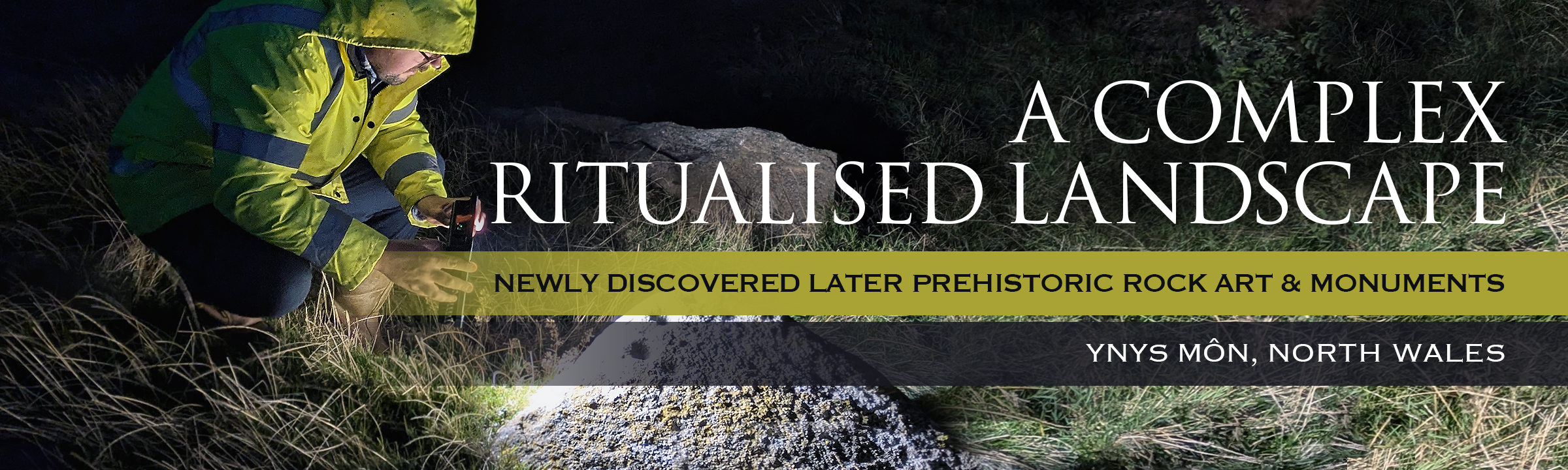
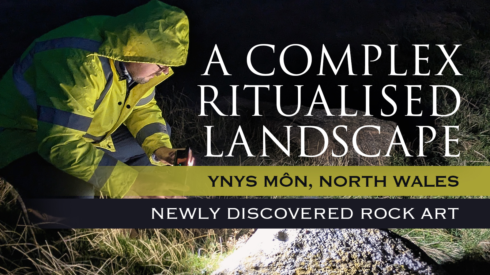
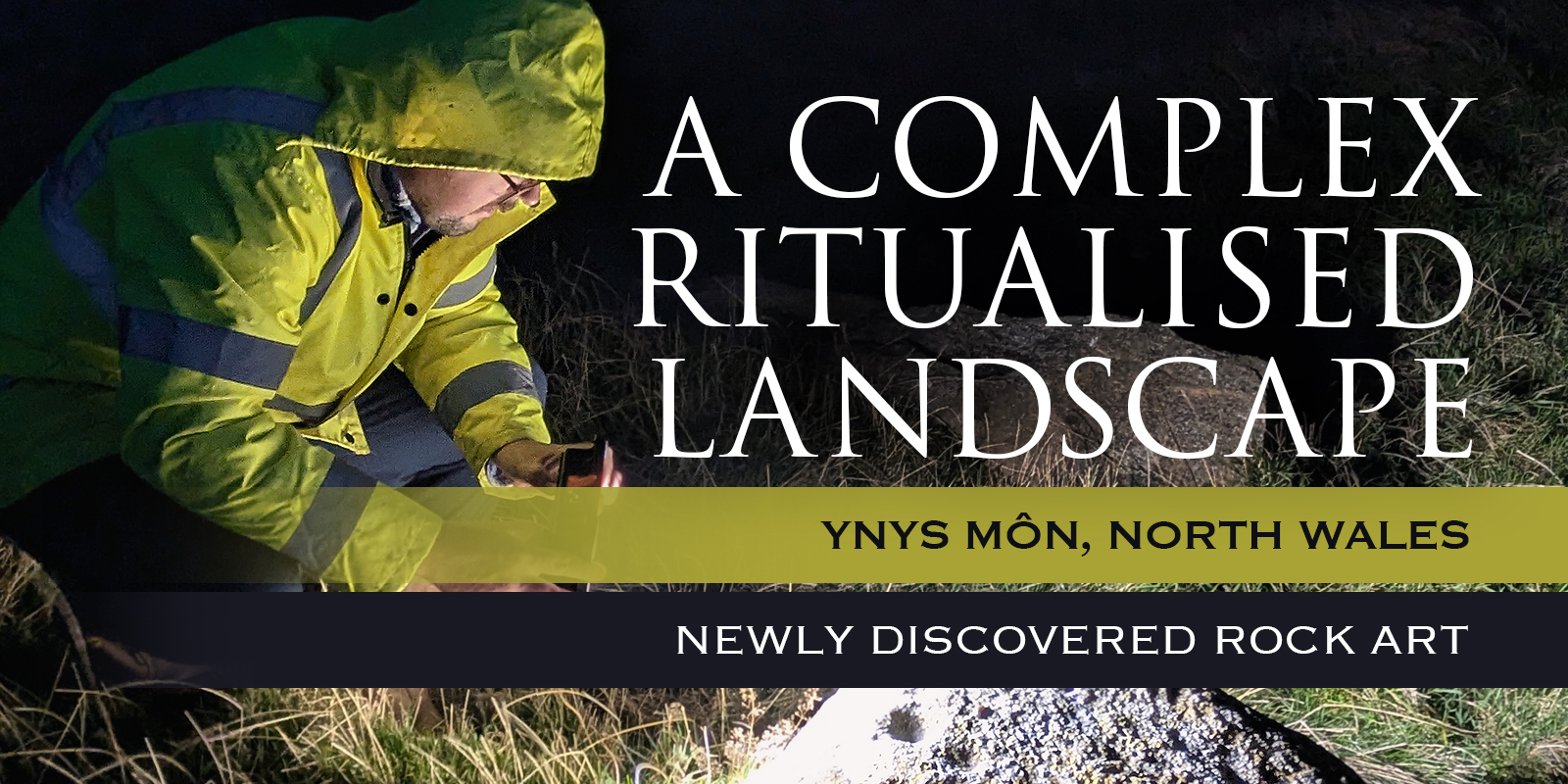
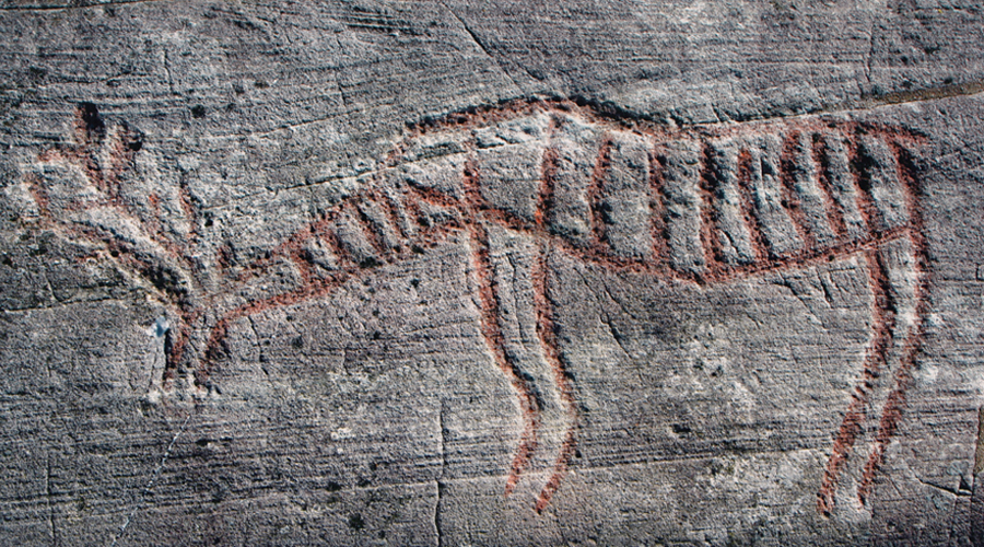
To discover a new Neolithic chambered tomb is considered a rare occurrence; however, to find a chambered tomb, two standing stones, a later prehistoric or early medieval enclosure and, pertinent to this article, three later prehistoric rock art panels is extraordinary!

In 2020 Mike Woods and Arwyn Owen discovered this site complex on and around the summit of a small but prominent hillock known as Pen y Foel. The then possible chamber tomb was partially excavated, and the results subsequently published. In 2023 and 2024, George Nash was invited to verify and record the three rock art panels. The team were largely in agreement that this complex had potential significance, revealing through LiDAR, the remnants of a group of later prehistoric monuments that formed a fragmentary ritualised landscape. This article takes the reader on a journey of discovery of a Neolithic/Bronze Age symbolic landscape that is only one of three that are present in Ynys Môn.

Introduction

A complex ritualised landscape: Newly discovered later prehistoric rock art and monuments in Ynys Môn, North Wales
Figure 1. Plan of the Pen y Foel hillock and its location in Ynys Môn. Key: CR = Cromlech; RA = Rock Art; SS = Standing Stone
© Nash, Owen & Woods
A complex ritualised landscape: Newly discovered later prehistoric rock art and monuments in Ynys Môn, North Wales
Figure 1. Plan of the Pen y Foel hillock and its location in Ynys Môn. Key: CR = Cromlech; RA = Rock Art; SS = Standing Stone
© Nash, Owen & Woods
A complex ritualised landscape: Newly discovered later prehistoric rock art and monuments in Ynys Môn, North Wales
Plate 1. View of Bedd y Foel and the lower slope of Pen y Foel, looking east towards Mynydd Bodafon
© Nash, Owen & Woods
This article discusses ongoing archaeological fieldwork and research in and around the summit of Pen y Foel, east of the village of Llanerchymedd, NE Ynys Môn. This small hillock has within its summit and lower slopes, a probable later prehistoric burial-ritual site (referred to in this article as Bedd y Foel), several standing stones and three rock art sites. Based on LiDAR data, all these sites appear to be incorporated in a later prehistoric or Celtic-medieval enclosure that forms around the upper contour of the hillock with its southern flank forming an east-west ridge (Figure 1). Between 2020 and 2022, a team of archaeologists undertook fieldwork that included a strip, map and record programme, along with a targeted excavation immediately west of a large stone block, what we consider to be a capstone belonging to a Neolithic burial-ritual site. In 2024, the three rock art sites were verified by the authors as being probably Late Neolithic or Bronze Age in date.

A complex ritualised landscape: Newly discovered later prehistoric rock art and monuments in Ynys Môn, North Wales
Plate 2. The enormous stone block, probably a capstone with a cupmarked upper surface, looking NW
© Nash, Owen & Woods
The later prehistory of Ynys Môn (Anglesey) boasts one of the most concentrated areas of burial-ritual monuments in Wales, with up to 16 extant stone chambered monuments that mainly occupy the coastal fringes of the island (Lynch 1991; Cummings & Whittle 2004; Nash 2006). A further 13 sites are recorded as being destroyed or doubtful, as briefly mentioned by Danial (1950) and Powell et al. (1969). Probably associated with this megalithic presence are numerous standing stones and menhirs (Lynch 1991). Accompanying these busy landscapes is a small assemblage of engraved rock art which is contemporary with Neolithic and Bronze Age monumentality (Sharkey 2004; Nash et al. 2005; Nash et al. 2010).

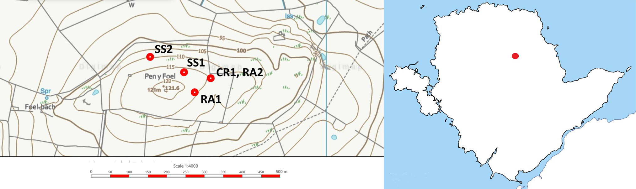
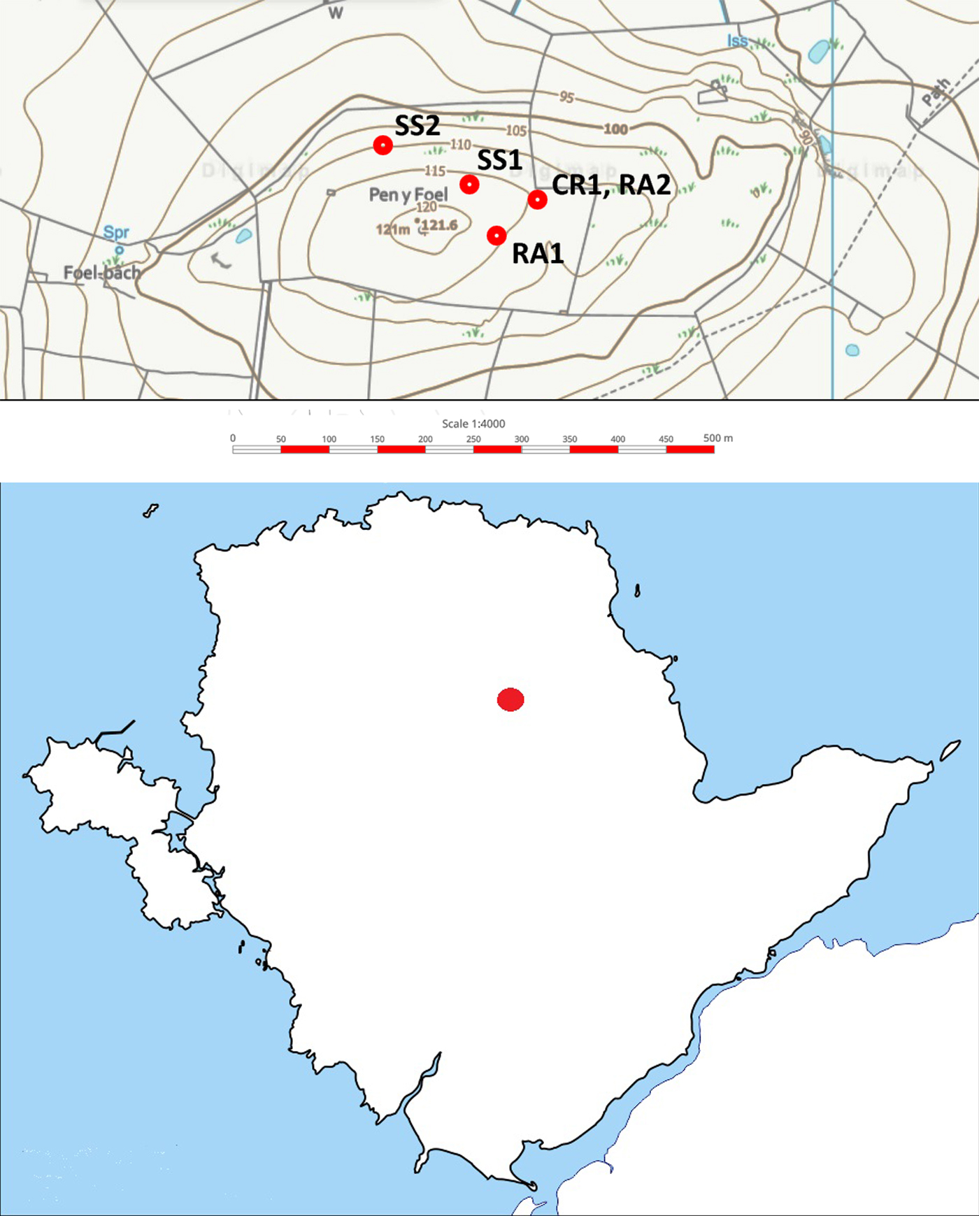
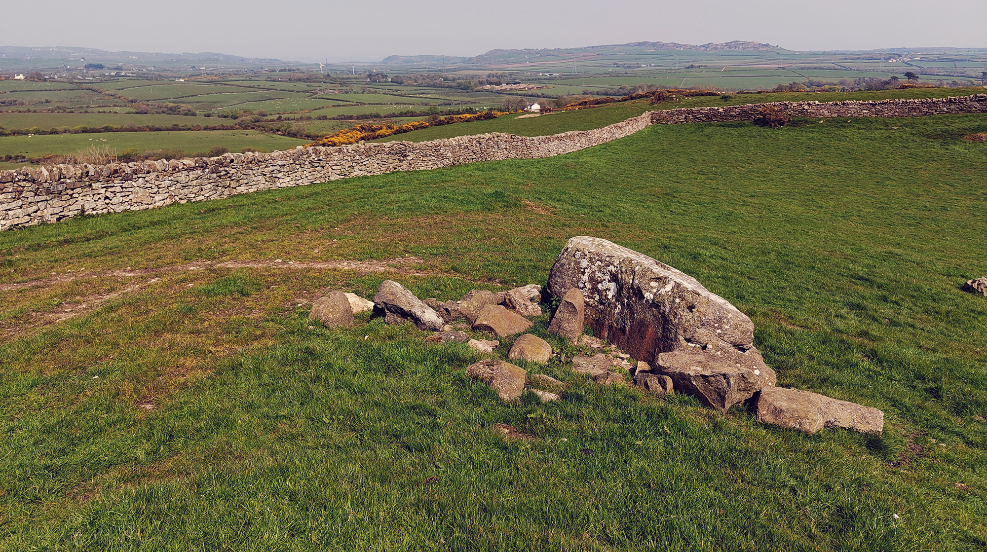
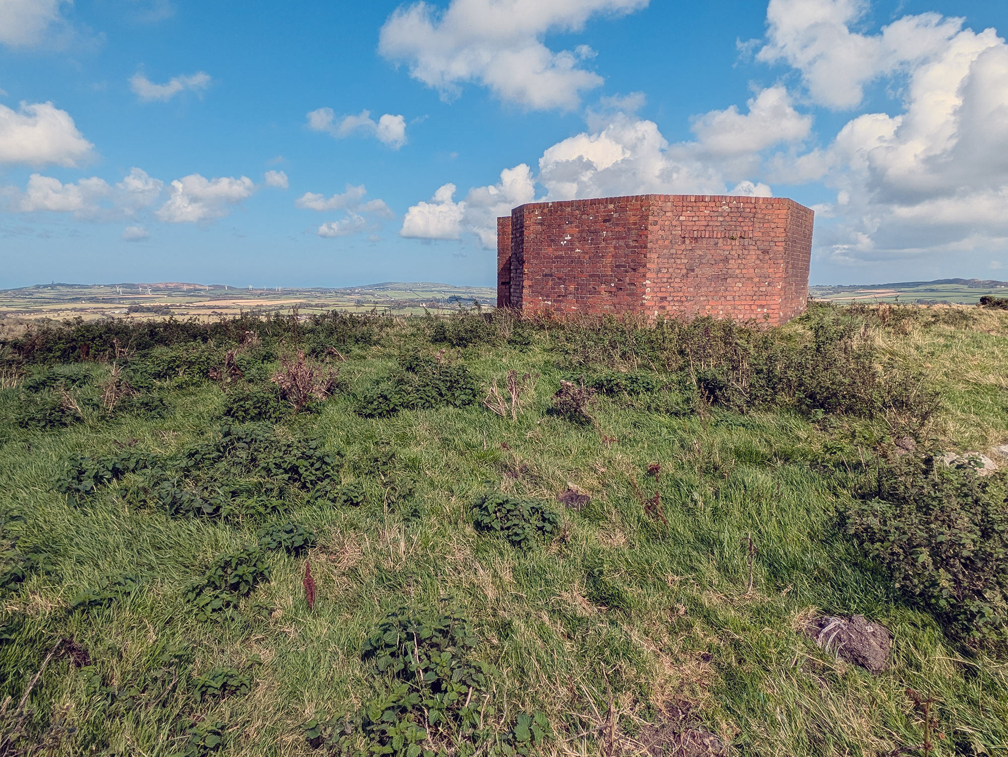
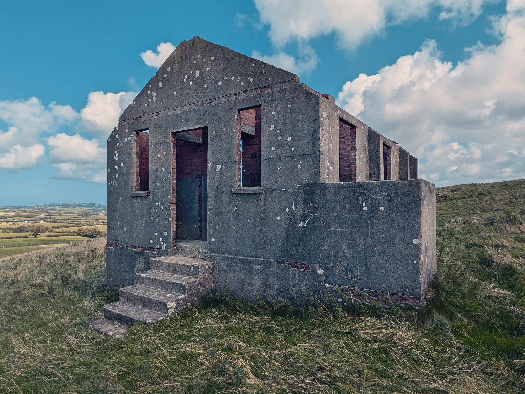
In 2021, the authors with a team of volunteers excavated a potential megalithic site known as Bedd y Foel which is located on the lower western slope of Pen y Foel, a small but strategic hillock (the hillock is locally known as the Foel, meaning the bald or barren) (Plate 1 & Plate 2). In addition to the fieldwork, the team also surveyed the wider landscape, using a variety of desk-based techniques including satellite imagery and LiDAR. These approaches assisted in allowing the team to identify other potential sites that occupied the summit and lower slopes of Pen y Foel.

A contextual view of the site

Ynys Môn has a long history that now extends back to the latter part of the Late Upper Palaeolithic (based on several dated pits located south of Wylfa). The most visible monuments though are the stone chambered burial-ritual sites and their associated landscape monoliths of the Neolithic and Bronze Age periods. These sites, have over the past 150 years been the focus for antiquarian and archaeological investigations (see Baynes 1910-11; Lynch 1976). The Neolithic passage graves of Barclodiad y Gawres and Bryn Celli Ddu, excavated during the early to mid-20th century using then up-to-date fieldwork techniques provided many answers to understanding the burial practices for this monument type (Hemp 1930; Powell & Daniel 1956). However, other sites, classified as Dolmens (and sometimes referred to as Cromlechs) have an unfortunate archaeological past, due mainly to antiquarian investigations, with much of the contents from each monument being archaeologically unrecorded, stratigraphy unceremoniously removed and artefacts ending up in private collections – their context lost.

Based on extensive surveys around Wales, it appears that many, if not all Neolithic and Early Bronze Age burial-ritual sites would have been associated with landscape monuments, such as standing stones and stone rows (e.g., Britnell & Whittle 2022; Cummings & Whittle 2004; Tilley 1994). The regional Historic Environment Record (HER) contains a list of at least 65 standing stones in Ynys Môn. These enigmatic structures usually occupy the same landscapes as the burial-ritual stone chambered monuments. It is more than probable that many more standing stones and burial-ritual monuments existed but have been destroyed, removed, reinstated elsewhere or await discovery. Indeed, the antiquarian, the Reverand John Skinner undertook a 10-day tour of Anglesey in 1802 and remarked in his diary that he had witnessed the dismantling of at least six monuments during his stay (Skinner 1802 [transcribed by T.P. Williams 2004]). Based on Skinner’s account and other antiquarian records, monuments had begun to lose their [supernatural] power, and the folklore associated with this group of monuments, and as a result, they became collateral victims. This 18th and 19th century mindset marks the final death knell in protecting such sites. In many instances stone chambered monuments became nothing more than quarries for the construction of buildings, field boundaries and road construction (e.g., Brück 2001). Today, many of the Neolithic burial-ritual monuments in Ynys Môn (and elsewhere in the western British Isles) are incomplete, a victim of the dismantling that took place during this time; the site of Bedd y Foel and its associated landscape monuments is no exception to this Age of Enlightenment!

Geological considerations

The natural geology of the locality comprises a gritstone; however, the monuments identified within our landscape survey, including the capstone, the two standing stones and the rock art panel on the southern ridge of the hill indicates the geology to be of hornblende picrite (BGS). This specific geology is an igneous rock that is only found in a few isolated surface outcrops; one of these being around nearby Llanerchymedd. Despite the availability of the gritstone geology around the summit of Pen y Foel, it appears that monument builders were selective in the material they used in construction. It is conceived that colour and lustre of the minerality of the hornblende picrite may have attracted attention for monument construction.

The Fieldwork Programme

The newly discovered site of Bedd y Foel is located on the western slope of Pen y Foel. Despite its height and relatively small surface area, this natural feature has commanding views across much of northern Ynys Môn and is intervisible with the Bronze Age copper mine on Parys Mountain, and possibly, two Neolithic burial-ritual monuments within the coastal village of Benllech – Pant y Saer and Glyn. During the Neolithic period, the immediate landscape would have probably accommodated more standing stones, probably acting as processional markers, whereby communities with their dead would descend onto burial monuments in a proscribed way, across a landscape from their settlement areas [similar to the corpse roads of the medieval and early post-medieval periods] (Children and Nash 2001). Today, and based on Ordnance Survey mapping and the HER, the area around Pen y Foel has at least six standing stones and it is more than likely that these monoliths would have had an association with one or more burial-ritual stone chambered monuments: one of these possibly being Bedd y Foel.

A complex ritualised landscape: Newly discovered later prehistoric rock art and monuments in Ynys Môn, North Wales
Plate 3. Aerial view of the trench west of the capstone, looking north
© Nash, Owen & Woods
Prior to full scale excavation in May 2021, a strip, map and record programme were conducted in September 2020. This programme allowed the team to target several areas for excavation, including an area measuring 4m x 4m immediately west of the capstone (Plate 3). This work identified a layer of demolition rubble likely associated with monument activity. Several large stones were recorded, one with two faint cup marks and twin parallel grooves carved on its surface which may have been structural in nature – possibly the top of an orthostat (upright). In addition, a fragment of hornblende picrite was recovered – closer examination suggests that it may have been later modified to enhance two igneous inclusions which run parallel across the piece, evident with the presence of possible lateral tool marks along its edges (Kenney, pers. comm.).

As stated earlier, many monuments in Ynys Môn survive in varying states of poor preservation (e.g., Cromlech Farm [NGR SH 3604 9201], Din Dryfol [NGR SH 3963 7254], Hen-Drefor [NGR SH 5512 7731] and Ty Mawr [NGR SH 5390 7224]). Although several of these sites have been previously excavated, the artifacts and the architectural state of each monument is difficult to discern (e.g., Smith & Lynch 1987). We would suggest that the current state of Bedd y Foel, plus the confused evidence associated with its recent past has similar issues with monuments mentioned above. This site was initially identified as a possible Neolithic burial-ritual monument in 2020. As a result of this assessment, the site was later excavated by Arwyn Owen and Mike Woods in 2020, with the excavation extending through the Covid 19 period in 2021.

A complex ritualised landscape: Newly discovered later prehistoric rock art and monuments in Ynys Môn, North Wales
Plate 4. Aerial view of the monument showing the array of cairn material with the eastern section of the trench and abutting the capstone
© Nash, Owen & Woods
Bedd y Foel comprises a large capstone section with an assemblage of large stones, possibly the remnants of disturbed and destroyed structural elements, at the western end (Plate 4). Based on personal communications with the local community, along with historic mapping and aerial imagery, this site appears to have been moved wholesale several metres eastwards from its original position, at sometime during the mid-1940s when the immediate area to the east was used as a local dump (Owen & Woods 2020). Inspection of the western side of the capstone revealed evidence of recent fracturing activity, in the form of vertical drilling scars and sheering of the stone. It was on the upper surface of this stone that up to 10+ faint cupmarks were identified using oblique lighting during darkness hours (Plate 5 & 6).

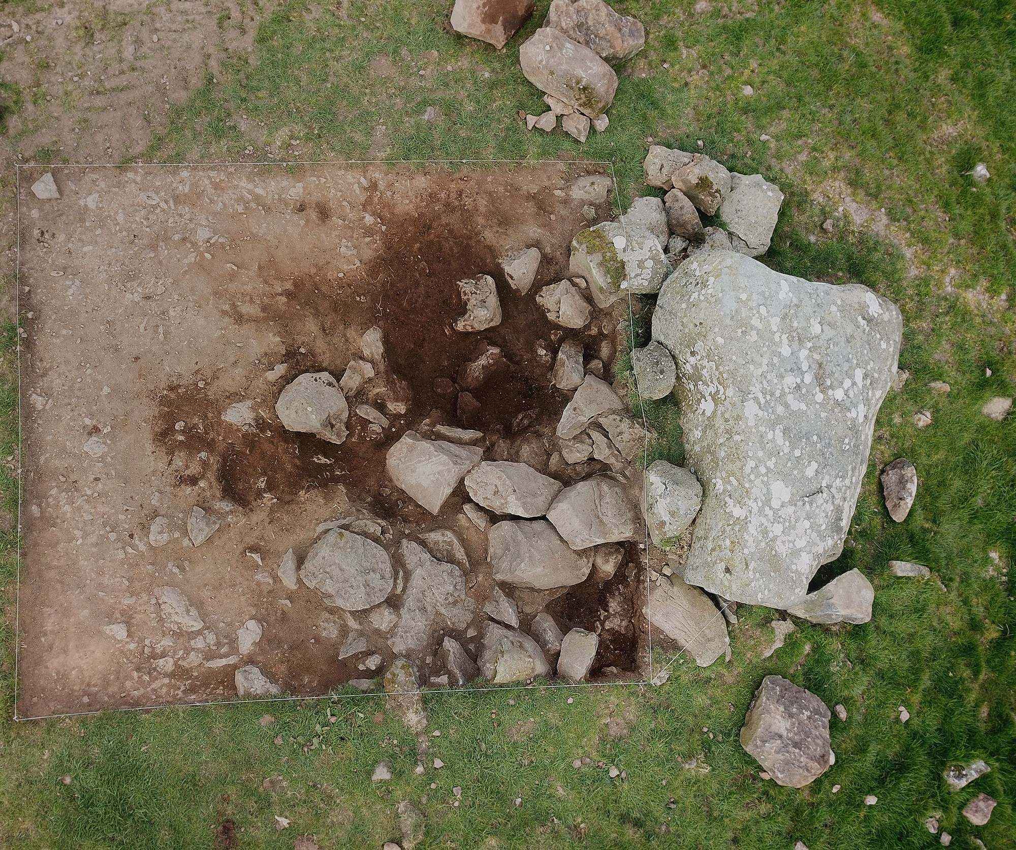
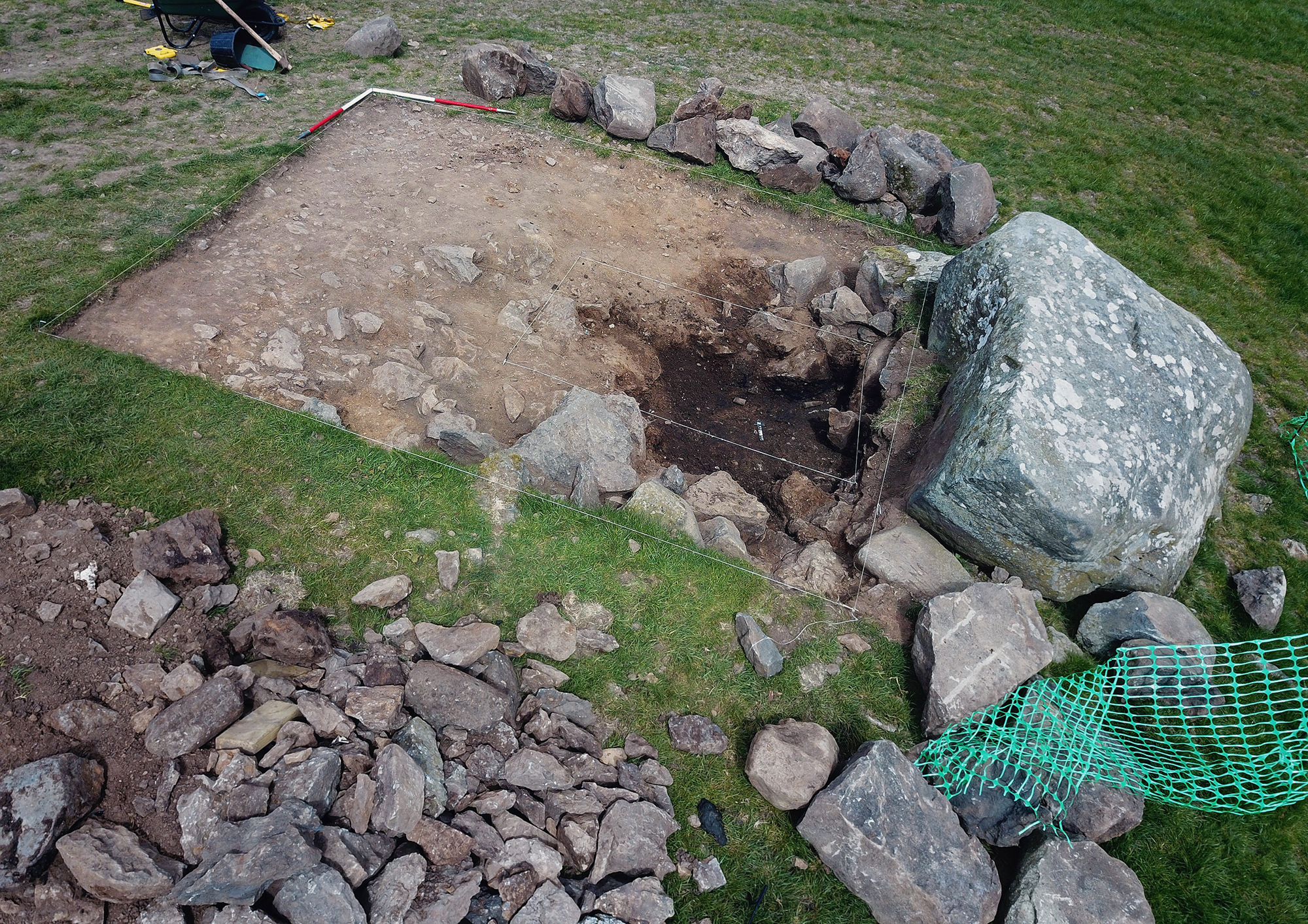
The team, along with volunteers, excavated a 4m x 4m trench within the western section of the site; an area that had been previously investigated in September 2020. The rationale was to attempt to uncover the remains of a chamber. Although the condition of the tomb was fragmentary and heavily disturbed, the team was hopeful that undisturbed archaeology remained in situ within a secure stratigraphic layer under the rubble identified previously.

Features recorded during the full-scale excavation included a large, worked stone, measuring 0.37m in height, 0.60m in length and a width of 0.46m, which was found to have been placed within a small curvilinear cut pit, into the earthen deposit above the outcrop, along with a small assemblage of stones that maybe the remnants of a packing deposit. This deliberate stone arrangement probably represented the base of an upright that would have once supported the nearby capstone (see similar scenario in Smith 2013). Uncovered within the base of the trench was a distinct compacted clay and stone floor surface (see Plate 4). The shape of the surface was roughly triangular in plan and measured 1.30m NE-SW and 2m NW-SE. It is probable that this surface and the stratigraphy above it had been heavily truncated by later historic disturbance.

A complex ritualised landscape: Newly discovered later prehistoric rock art and monuments in Ynys Môn, North Wales
Plate 5 & 6. Images showing oblique lighting which has enhanced the cupmarked surface of the capstone
© Nash, Owen & Woods
A complex ritualised landscape: Newly discovered later prehistoric rock art and monuments in Ynys Môn, North Wales
Plate 5 & 6. Images showing oblique lighting which has enhanced the cupmarked surface of the capstone
© Nash, Owen & Woods
The clay floor sat above the bedrock which showed evidence of a process known as fire setting, whereby the bedrock fractures due to burning and is then subsequently quenched with water and quarried out. The megalithic site of nearby Lligwy (NGR SH 50105 86055) has an identical sub-megalithic chamber construction (see Baynes 1909; Lynch 1991).

A complex ritualised landscape: Newly discovered later prehistoric rock art and monuments in Ynys Môn, North Wales
Plate 7. Stone artefacts retrieved from the excavation including a tapered cylindrical stone implement
© Nash, Owen & Woods
Due to acidic soils, no prehistoric human remains, or pottery were recovered during the excavation programme; however, several stone objects were found, including a long cylindrical polished stone that tapered at one end. This was in two pieces and were found within the chamber area, o.50m apart (Plate 7). The geology of the artefact was not native to the summit of the Foel, instead comprising of a quartz rich sandstone which appears to have originated from the Yorkshire Pennines. The geology suggests that this artefact would have proven to be both too brittle to be used as any type of functional impact tool. Instead, it is considered as being used in both sharpening and honing whetstones, say, during the late Bronze Age or Iron Age.

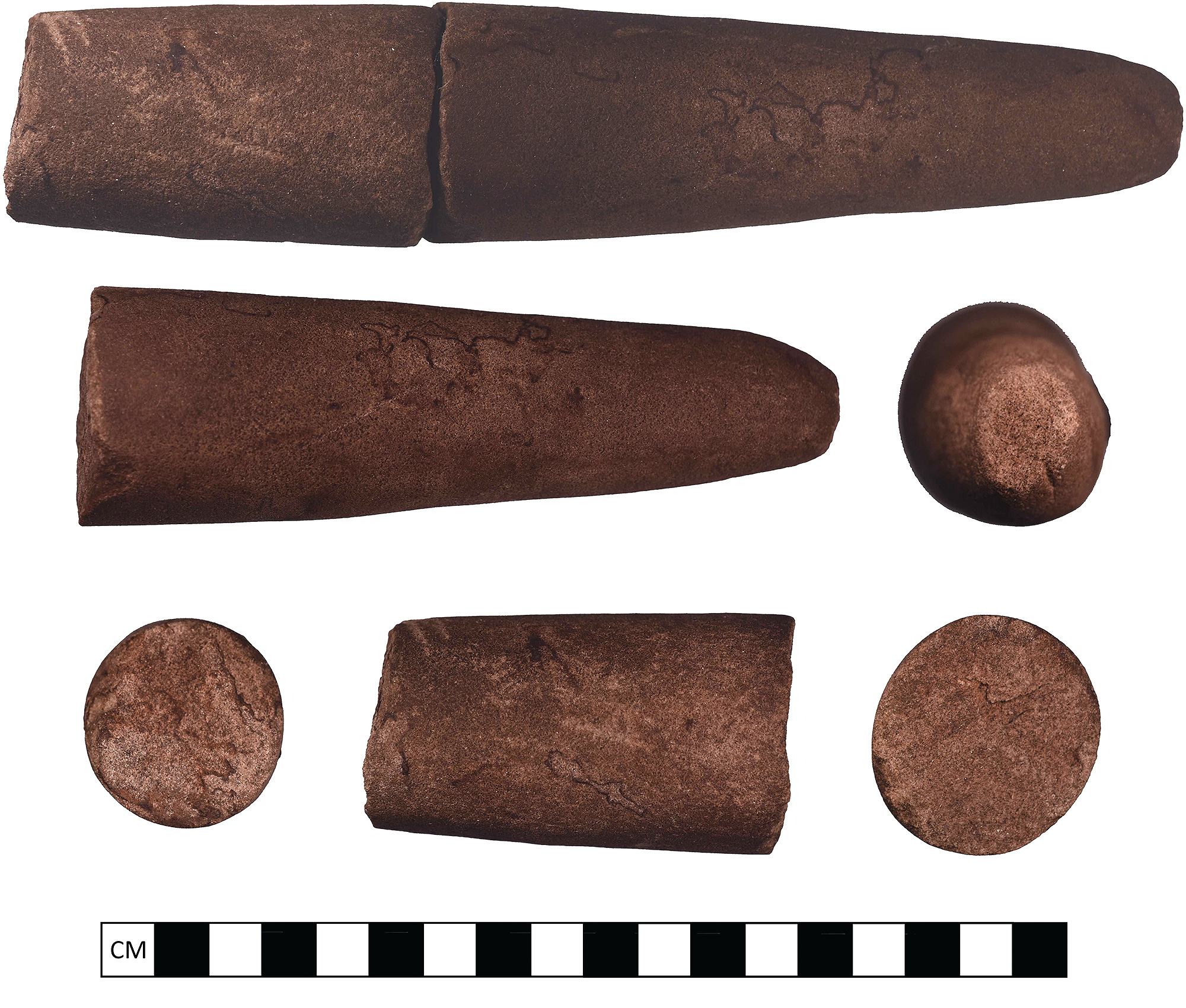
Other artefacts included a granite polishing stone that was found immediately south of the sharpening stone within the confines of the chamber. One end of the stone was worn flat. Comparable examples are reported at Neolithic tombs on Anglesey, such as nearby Pant y Saer (NGR SH 50962 82497) (Scott 1933), along with two worked pieces of black chert, which was found within the upper fills, above the clay surface. Although the finds from our excavation are considered meagre, we do stress that the monument proper had been relocated, albeit several metres to the east (as recalled by locals who remember the neighbouring dump being backfilled using plant machinery). It is more than probable that ground-truthing technology will, in the future provide some indication of the whereabouts of a cairn and other architectural features associated with this much-disturbed monument.

Marking the landscape

A complex ritualised landscape: Newly discovered later prehistoric rock art and monuments in Ynys Môn, North Wales
Plate 8. A World War II RFD [later known as RADAR] structure occupying the summit of Pen y Foel
© Nash, Owen & Woods
As part of our ongoing research programme, all available desk-based information was collated, including information supplied by national databases Archwilio and Coflein and the RCAHMW inventory for Anglesey (1937). These sources revealed that a number of archaeological sites were present within the bounds of the hillock, including many associated with historic quarrying operations and evidence of medieval and post-medieval agricultural regimes. In addition are two sites that date from World War II, a single celled billet/operations building with a porched entrance on its western gable end and (located at NGR SH 42494 84480) and an RFD tower base (located at NGR SH 42569 84418) (Plate 8 & Plate 9). Both buildings are located on the summit of Pen y Foel and have compass point views across much of north and east Ynys Môn. Their presence, similar to other operational sites in North Wales and the Irish Sea coastline was to alert the armed forces of any imminent invasion along the NW coastline of the island (see CBA’s Defence of Britain Project, which ran between 1995 and 2001). In addition, archaeological works in the immediate Llanerchymedd area have identified a small Neolithic pit group near Cae Mawr farm, 1.7km NW of Pen y Foel, in November 2021 (Philp 2022) as well as a possible prehistoric settlement identified through geophysical survey in a field south of St Mary’s Church, Llanerchymedd, 1km SW of Pen y Foel (Owen 2020).

A complex ritualised landscape: Newly discovered later prehistoric rock art and monuments in Ynys Môn, North Wales
Plate 9. A World War II billet/operations building occupying the summit of Pen y Foel
© Nash, Owen & Woods
Prior to our investigations and fieldwork around the Bedd y Foel site, regional and national databases listed only a handful of prehistoric sites, including several standing stones to the east of Pen y Foel and a possible section of a capstone which had an elaborate engraved surface at Llwydiarth Esgob Farm, some 86m east of Bedd y Foel (see Lynch 1991; Nash et al. 2010). The stone, possibly the remains of a capstone belonging to a dolmen-type monument was probably collected locally by the farm’s occupier, the celebrated antiquarian Thomas Pritchard during the early part of the 20th century. We hasten to add though that the Llwydiarth Esgob Stone did not originate from the Bedd y Foel site. Beyond the immediate area, further later prehistoric sites are distributed across the northern Ynys Môn landscape including two megalithic stone chambered monuments within the western part of the coastal town of Benllech (Pant y Saer and Glyn), and to the northeast (Lligwy and a destroyed site near Llanallgo). In addition to these sites is a destroyed monument near the base of Bodafon Mountain directly east (Skinner 1802 [transcribed by T.P. Williams 2004] and Williams 1867) and to the northwest - the now heavily damaged Cromlech Farm (also known as the Llanfechell Cromlech). Several of these sites, or at least the areas in which they stand would have been intervisible with Bedd y Foel. Additionally, a possible prehistoric routeway is suggested to run east-west across the island, part of it within the immediate confines of several prehistoric monuments within the vicinity of Pen y Foel, fossilised as large sections of the present B5112 road and the smaller, unnamed road from Llanerchymedd travelling eastward towards Brynteg (Davidson, pers comm.).

Within the immediate landscape

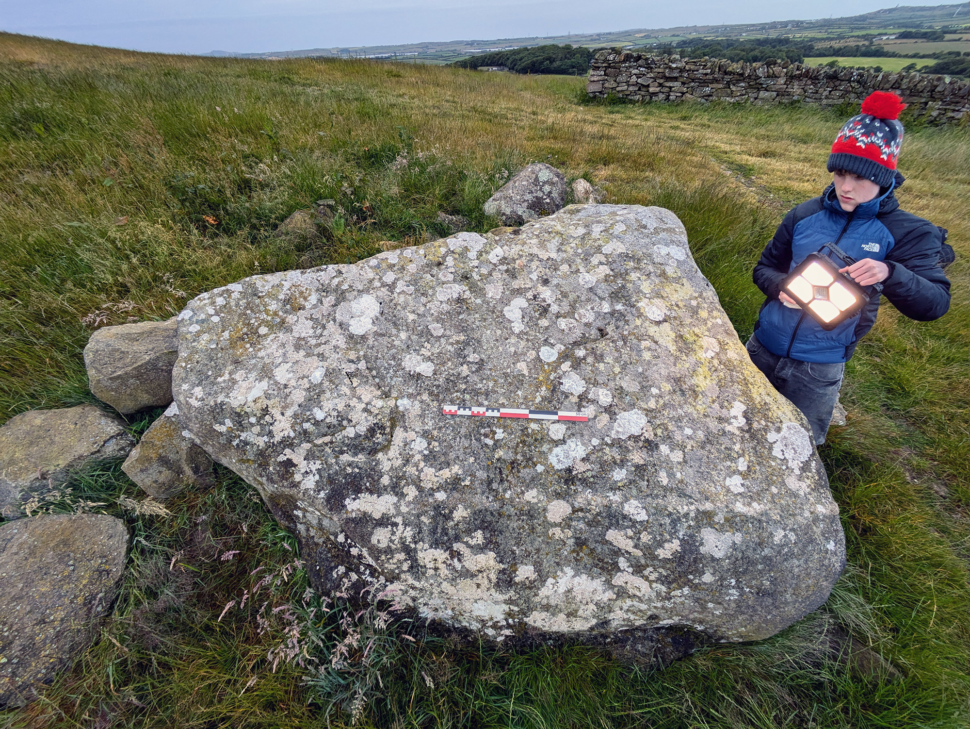
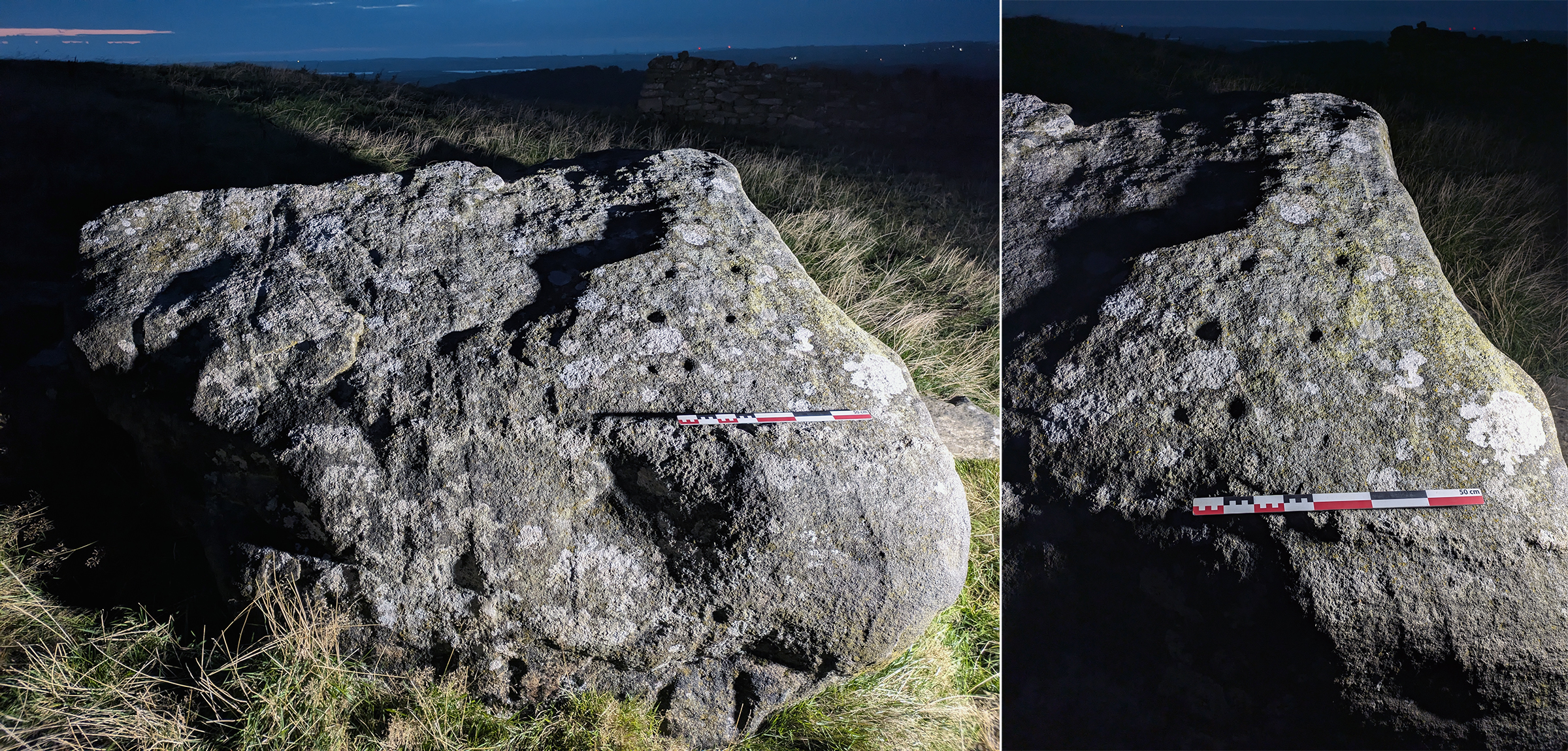
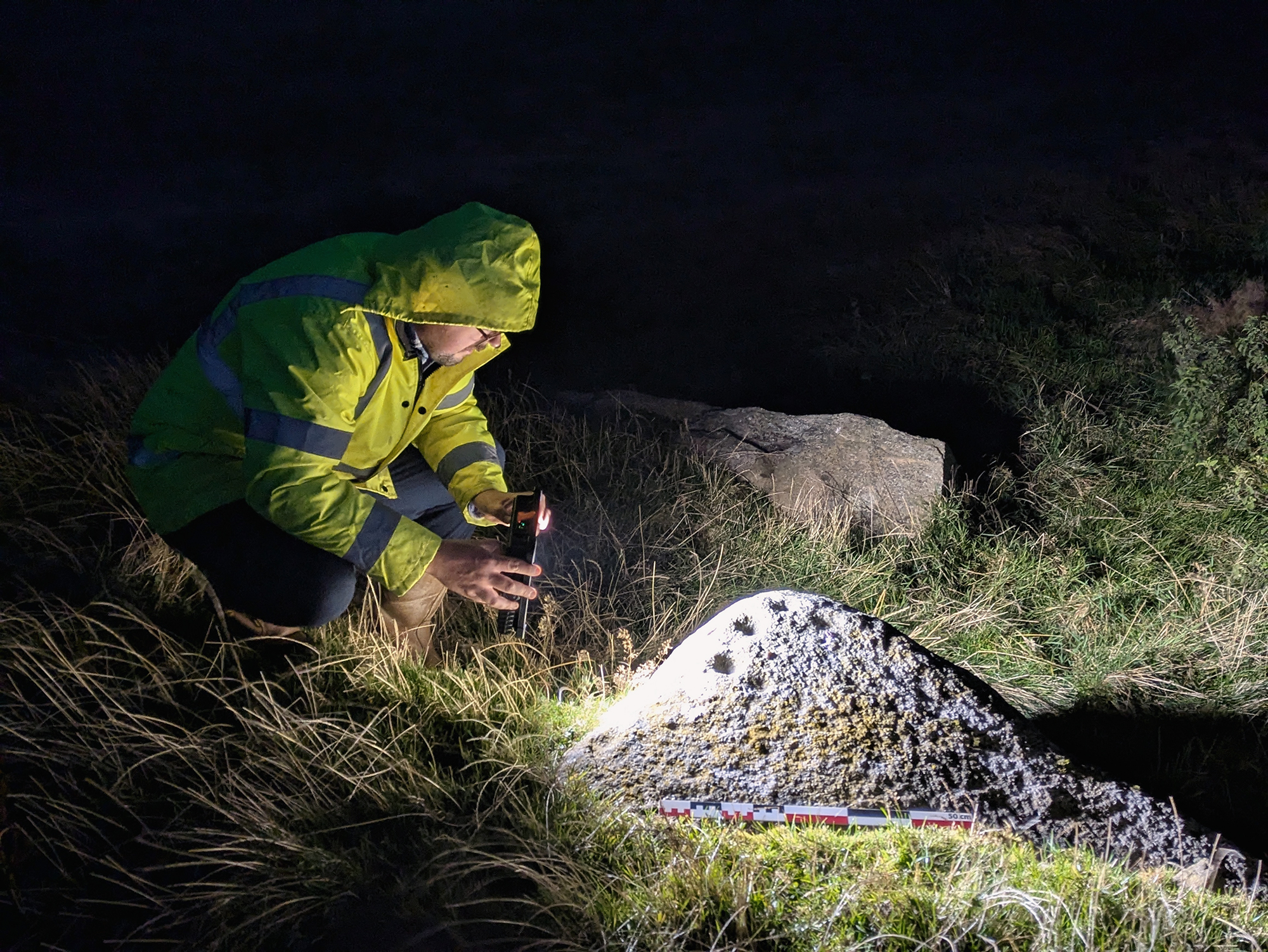
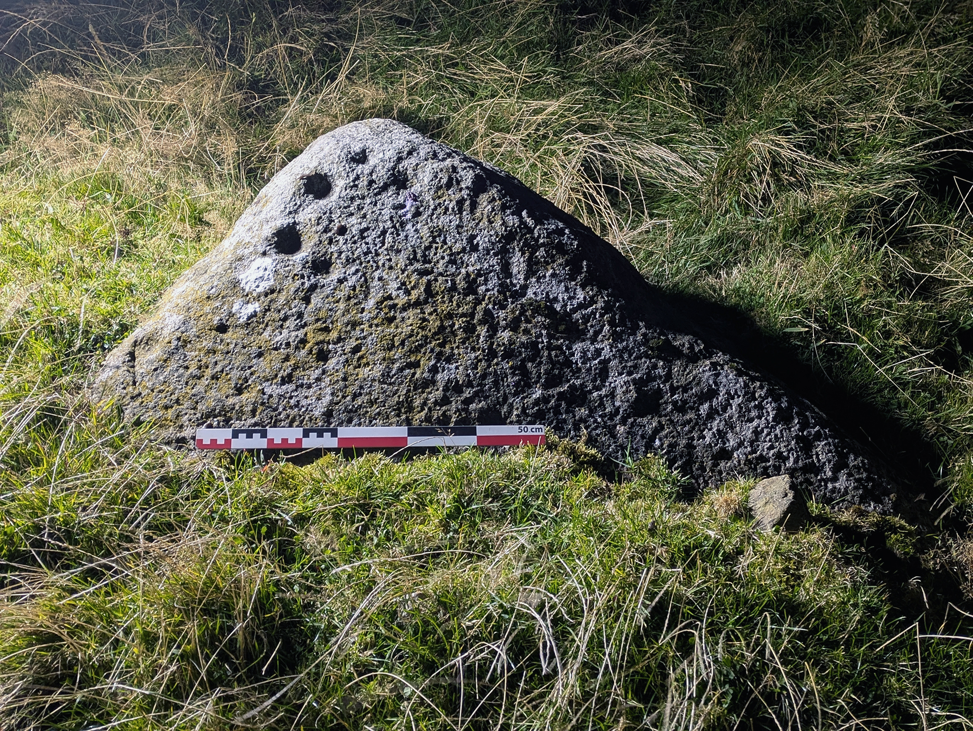
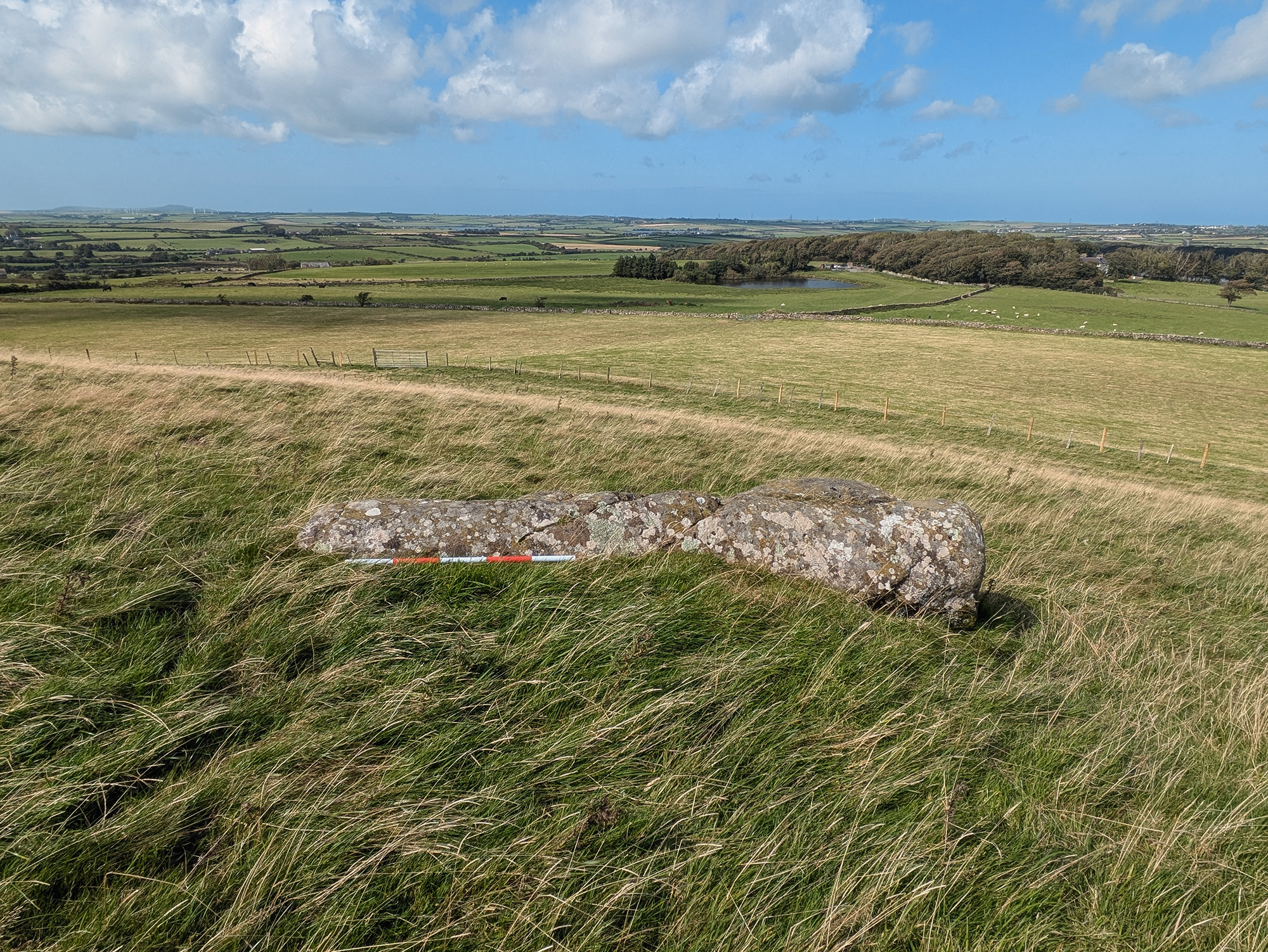
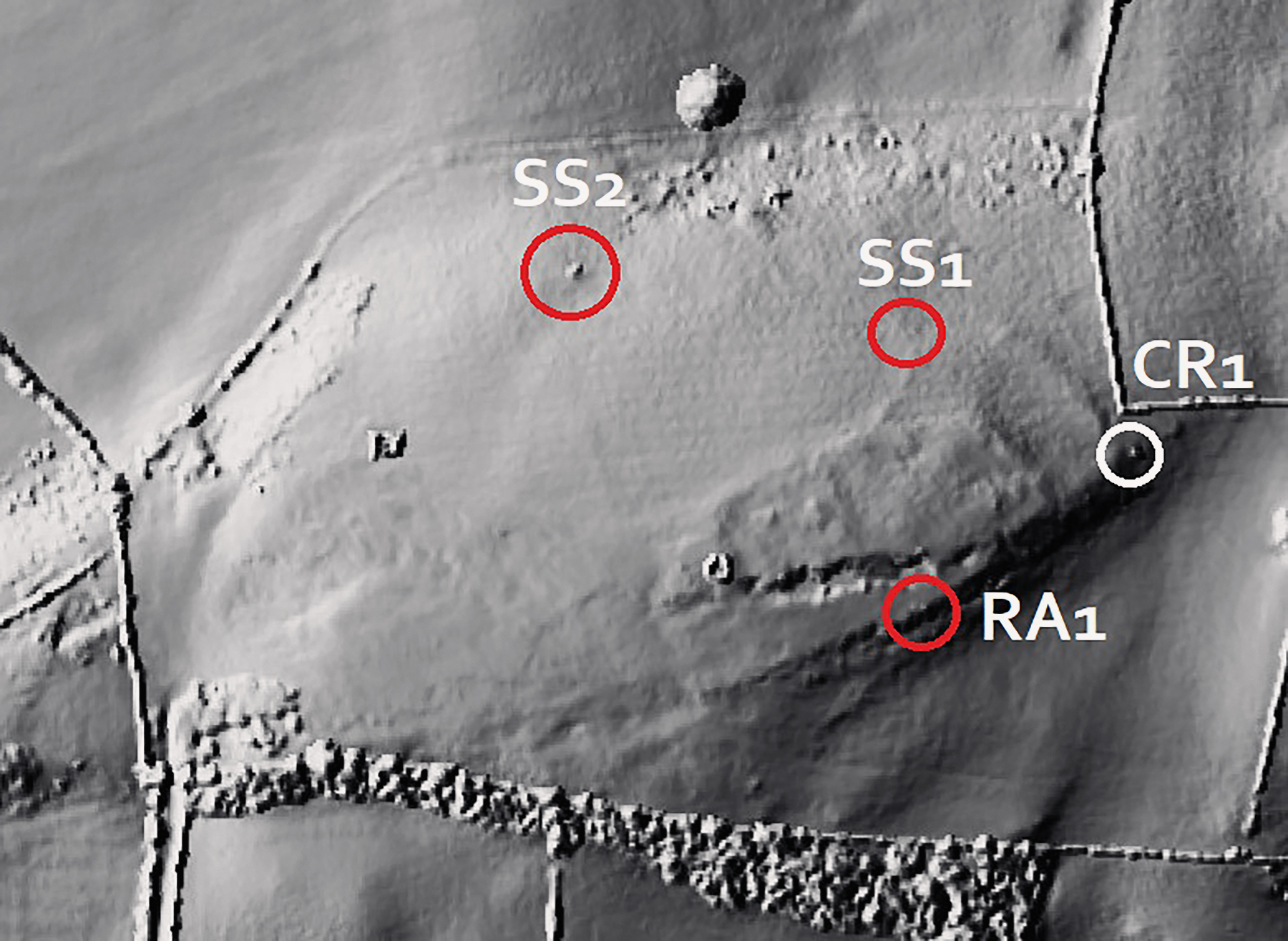
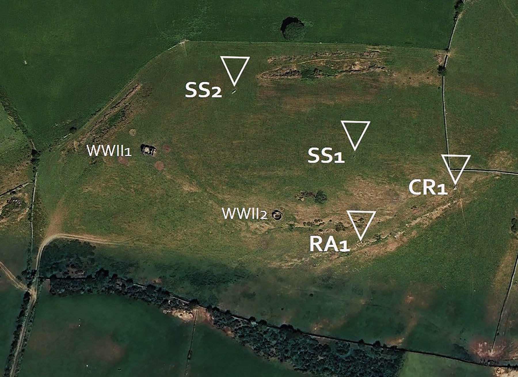
Apart from the Bedd y Foel monument, the team had also noticed three other sites worthy of further investigation, including two isolated monoliths, possibly prehistoric standing stones, and a large earth-fast boulder with engraved cupmarks on its upper surface (Plate 10, Plate 11 and Plate 12). The presence of these potential monuments reinforced the notion that sites on Pen y Foel constituted a ritualised later prehistoric landscape, whereby all the monuments recorded by our team interacted with each other, mainly via intervisibility and recognised architecture (e.g., Tilley 1994; Tilley and Bennett 2001).

A complex ritualised landscape: Newly discovered later prehistoric rock art and monuments in Ynys Môn, North Wales
Plate 10. (left) The smaller of the two monoliths, located on the eastern brow of Pen y Foel
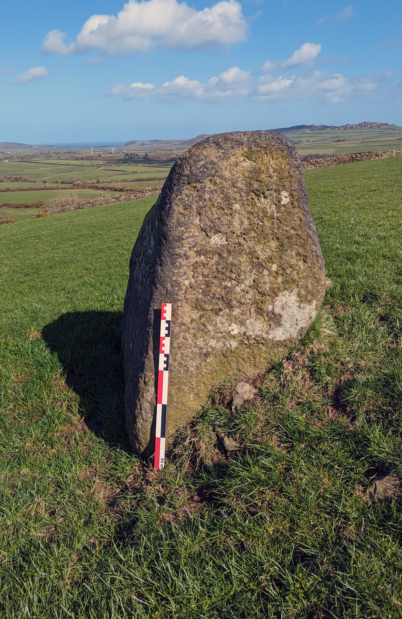
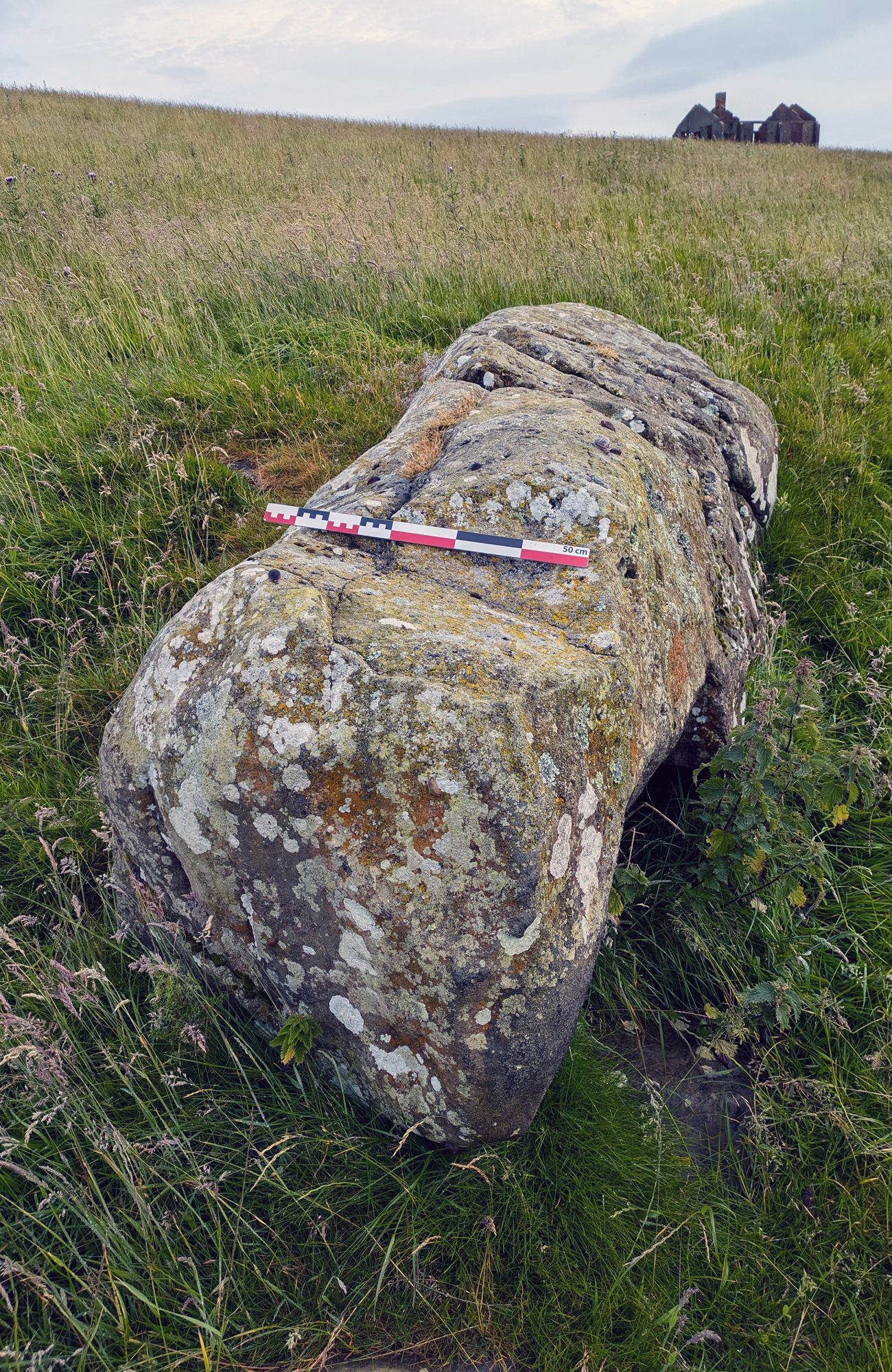
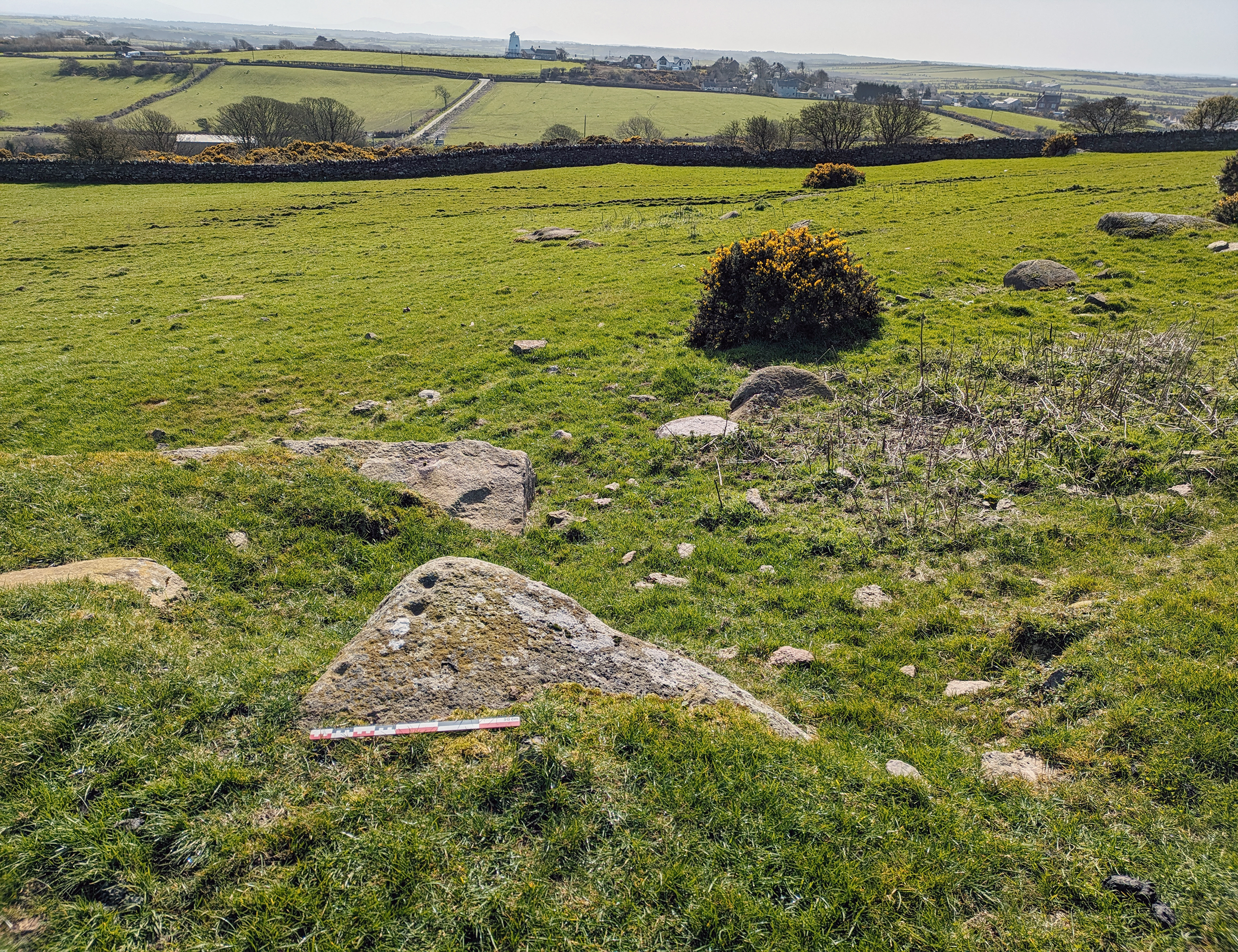
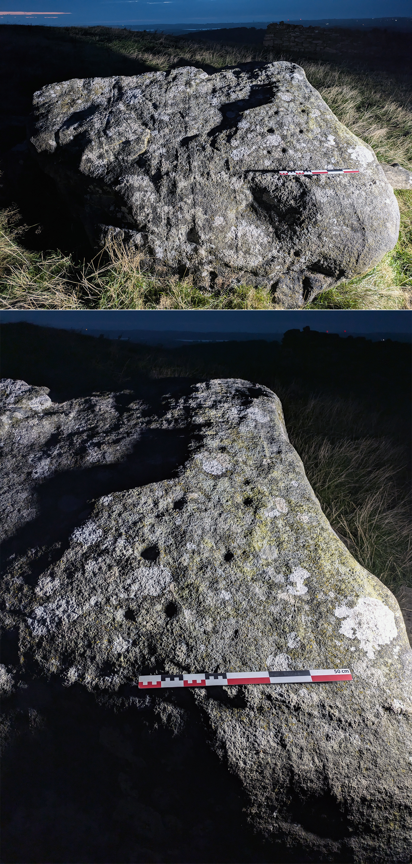
Plate 11. (center) A large monolithic stone, possibly a menhir, located on the NW slopes of Pen y Foel
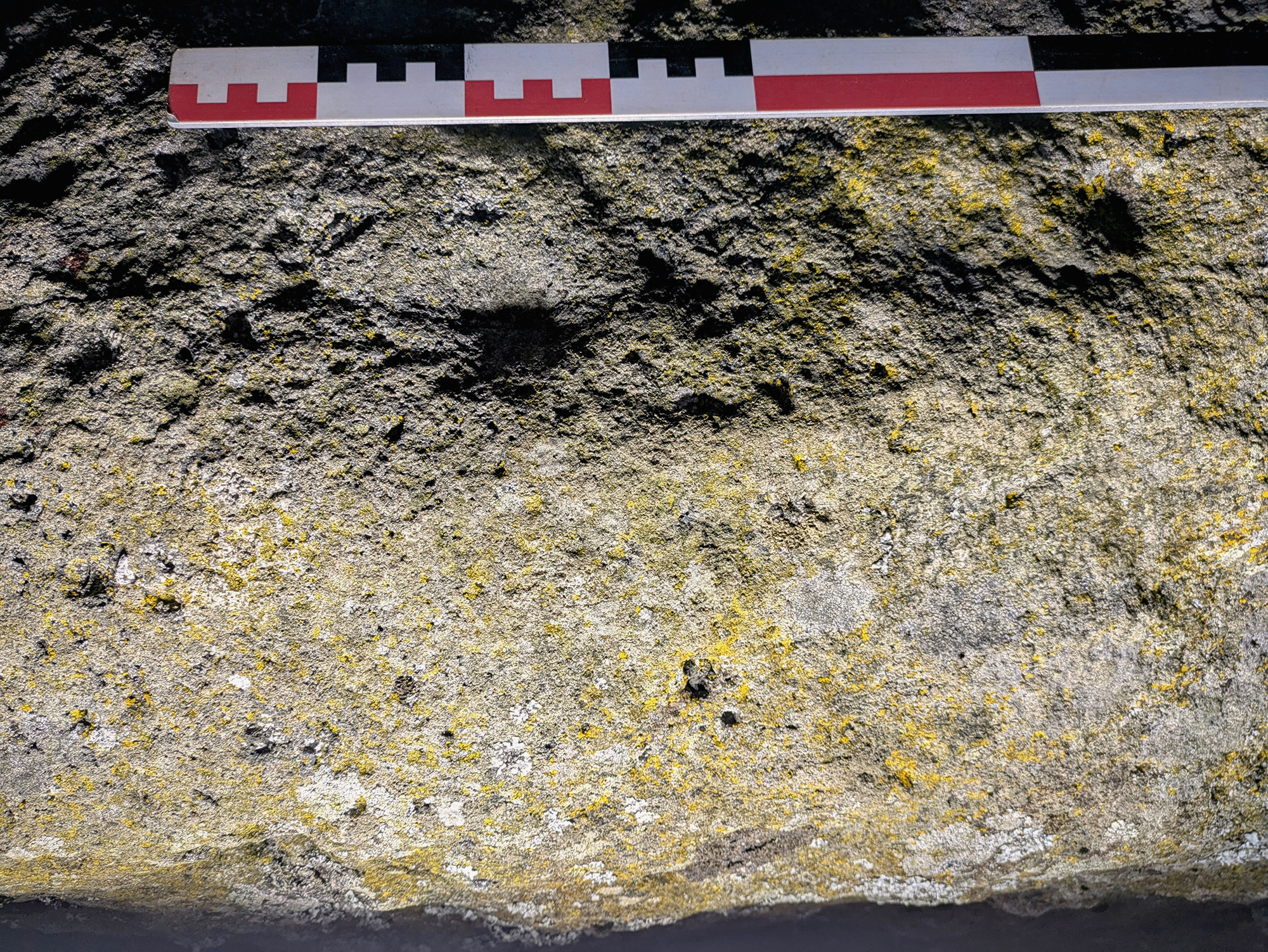
Plate 12. (right) Cupmarked stone, located along the southern ridge of Pen y Foel, overlooking central Ynys Môn and the Snowdonia Range beyond
© Nash, Owen & Woods
A complex ritualised landscape: Newly discovered later prehistoric rock art and monuments in Ynys Môn, North Wales
Plate 10. The smaller of the two monoliths, located on the eastern brow of Pen y Foel
© Nash, Owen & Woods
A complex ritualised landscape: Newly discovered later prehistoric rock art and monuments in Ynys Môn, North Wales
Plate 11. A large monolithic stone, possibly a menhir, located on the NW slopes of Pen y Foel
© Nash, Owen & Woods
A complex ritualised landscape: Newly discovered later prehistoric rock art and monuments in Ynys Môn, North Wales
Plate 12. Cupmarked stone, located along the southern ridge of Pen y Foel, overlooking central Ynys Môn and the Snowdonia Range beyond
© Nash, Owen & Woods
The two standing stones were located west of the dolmen site, each occupying the lower slope area of Pen y Foel. The smaller of the two standing stones (located at NGR SH 42619 84472) stands 75m west of the dolmen at 0.90m above the ground level. LiDAR evidence suggests that this stone was once incorporated into an N-S field boundary.

Similar to the potential dolmen site and the other recumbent standing stone to the west, this monolith has commanding views across much of northern Anglesey, with the southern slopes of Parys Mountain in full view. Despite its smooth, rounded taper, the stone appears to have been damaged in the distant past and would have been taller than present.

A complex ritualised landscape: Newly discovered later prehistoric rock art and monuments in Ynys Môn, North Wales
Plate 13. Using oblique lighting during darkness hours, identified on the upper surface of the stone is a clear cupmark (possibly two)
© Nash, Owen & Woods
Located further west, on the far-western slope of Pen y Foel, around 170m west of Bedd y Foel is the large recumbent stone, measuring c. 3.5m in length which may represent a fallen standing stone (what we term as a menhir) (see Plate 11 above). Assuming that a third of its length would have been embedded into the ground (at its southern end), the large monolith, or menhir would have stood around 2.5m above the ground level. At the NW end of the stone, there is clear evidence that this potential monolith is not physically connected to the bedrock. Based on its shape and position within the landscape, plus, it is the only stone of its size occupying the slopes of Pen y Foel, it is an obvious candidate for a later prehistoric monolith. This interpretation is further reinforced by the presence of a single cupmark that has been engraved onto the upper face of the stone (Plate 13).

The two standing stones and the dolmen form an intriguing alignment that is roughly orientated NW-SE, with the dolmen being the SE terminus point. It is probable that other landscape monuments occupied the land either side of the dolmen but have since been destroyed or incorporated into later field boundaries which are now hidden from view. We note that a standing stone is located east of Llwydiarth Esgob Farm, at NGR SH 44670 84315. This monolith appears to be a continuation of the Pen y Foel alignment. Other standing stones within the vicinity of the Pen y Foel ritual monument complex include stones at NGR SH 45215 83115 and NGR SH 46085 83370. All three monoliths appear to bridge the landscape gap between Pen y Foel and the Benllech group of monuments, located c. 9km to the east. Based on their distribution across the northeastern side of Ynys Môn, we could be witnessing a procession routeway between two burial-ritual monument clusters, whereby grieving communities and the dead are guided across the landscape via a line of standing stones.

Inscribing the landscape

A complex ritualised landscape: Newly discovered later prehistoric rock art and monuments in Ynys Môn, North Wales
Plate 14. Arwyn Owen providing oblique lighting in order to illuminate the stone and its cupmarks
© Nash, Owen & Woods
Identified within the Pen y Foel landscape were three cupmarked stones which included the menhir and the capstone (two of which are discussed previously in the article). The capstone, with its 10 faint cupmarks on its uppers surface, has similarities with the cupmarked capstone of Ty Newydd, located east of the coastal village of Rhosneigr, along the western part of the island (Phillips 1936). The third and most visible site was a stone which was located on a natural ridge that forms the southern flank of Pen y Foel (Plate 14 & Plate 15). The rock art comprises six or more cupmarks that are carved on the eastern (left) edge of a much-weathered stone.  Several cups, each measuring 4-5 cm in diameter are cut deep into the surface of the stone. The stone is partially embedded into a south-facing ridge that probably forms part of a natural boundary of a later prehistoric or Celtic-medieval enclosure (as recorded on LiDAR).  The ridge and earthworks appear to occupy the summit of Pen y Foel. We would suggest that the cupmarked stone was in use when the landscape was being ritualised during the Late Neolithic or Bronze Age. It may be that further cupmarks are buried underneath the turf that covers the northern section of the stone.

A complex ritualised landscape: Newly discovered later prehistoric rock art and monuments in Ynys Môn, North Wales
Plate 15. Detail of the cupmarked stone using oblique lighting during darkness hours
© Nash, Owen & Woods
In terms of the landscape to the south of this cupmarked stone and Bedd y Foel, the vista includes a 180–220-degree uninterrupted view that includes the eastern section of Llanerchymedd and the central lowlands of Ynys Môn beyond.  Incorporating the compass views of this later prehistoric ritual complex is the cupmarked menhir, which occupies the northwestern slope and has commanding views across much of northern Ynys Môn, including the Bronze Age copper mine of Parys Mountain, which is located 7km to the north (Plate 16). This 365-degree compass view of the surrounding landscape is the only upland area within the locality, with the height of the summit being c. 125m AOD. It is from the summit and the lower eastern slopes of Pen y Foel that one can see the area around the Lligwy burial-ritual monument, some 8.5km to the east.

LiDAR data

A complex ritualised landscape: Newly discovered later prehistoric rock art and monuments in Ynys Môn, North Wales
Plate 16. The long axis of the menhir and the commanding views this monument has to the NE
© Nash, Owen & Woods
We now turn our attention to LiDAR data which has further complicated, but also enhanced the archaeology in and around Pen y Foel. Identified were a series of features indicative of a possible later prehistoric and/or Celtic-medieval landscape, including an oval-shaped enclosure and an associated terraced allotment-sized field system immediately west of Bedd y Foel and the nearby rock art panel that is incorporated into the southern ridge (Figure 2). The LiDAR image has revealed the shape of the enclosure and suggests it survives as a sub-surface low-banked earthwork. Again, visible and adding to the complex narrative of Pen y Foel are the two World War II structures that occupy its southern and western sections of the summit, along with historic quarrying activity to the south and west. Clearly visible from the LiDAR imagery is Bedd y Foel (CR1) and the far western standing stone (SS2), what we term a menhir. Between these two monuments is the small standing stone which appears to have been incorporated into a former N-S field boundary (SS1). Interestingly, and despite its wholesale relocation, the capstone was also once incorporated into a fossilised stone and turf [?] boundary. To the south is the stone with five cupmarks on its upper face (RA1) ((Figure 2). What was revealing and what cannot be seen on the ground are the various field boundaries that are incorporated into the large enclosure. We correctly assume that these features are later than the burial-ritual landscape of the Neolithic/Bronze Age.

Identifying a later ritualised prehistoric landscape?

A complex ritualised landscape: Newly discovered later prehistoric rock art and monuments in Ynys Môn, North Wales
Figure 2. LiDAR image showing the location of the two standing stones (SS1 & SS2), the rock art site (RA1) and the cupmarked capstone belonging to a probable Neolithic chambered tomb (CR1)
© Nash, Owen & Woods
Based on the inventory and online resources, plus ongoing fieldwork since 2020, Pen y Foel constitutes a significant contribution towards further understanding the relationship between burial-ritual sites, associated landscape monuments and later economic features, such as field boundaries and the enclosure. It is clear that single monuments cannot be looked at in isolation. The discovery and excavation of Bedd y Foel, the cup marked stones, the two standing stones and earthwork features identified through LiDAR as well as fieldwalking has revealed a multi-phased landscape which involves 5000 years or more of human activity. Coupled with this, are findspots around nearby Llwydiarth Esgob Farm, where a number of later prehistoric artefacts have been found, including two Neolithic polished stone axes, originating from Langdale in Cumbria and Penmaenmawr in North Wales. These exotic finds, found within the vicinity of Pen y Foel indicates that complex Neolithic exchange networks were in operation. Arguably, these networks were not just confined to the immediate area but formed part of the Irish Sea Province, where contact and exchange networks were in operation during the Neolithic, as witnessed by the diverse tomb architecture that extends across much of North Wales, the Isle of Man, western Scotland and the eastern coastal zone of Ireland (Scott 1969; Nash 2006; Cummings 2009).

A complex ritualised landscape: Newly discovered later prehistoric rock art and monuments in Ynys Môn, North Wales
Figure 3. Google Earth image showing the rendered landscape (as of 2024)
© Google Earth
Given the concentration of monuments within such a small area, Pen y Foel is probably only one of three later prehistoric areas in Ynys Môn that can be labelled as a later prehistoric burial-ritual complex; the others being the landscapes of Bryn Celli Ddu and Llanfechell Cromlech. All other extant Neolithic monuments on the island do not possess this concentration of diverse monumentality. The landscape that surrounds this monument cluster appears to be the result of strategic choice, whereby the compass views from the summit of Pen y Foel included much of the northern landscape of Ynys Môn, including the uplands to the north and west. Incorporated into this panoramic view is Mynydd Bodafon within the central part of the island and the Snowdonia Range further south. This strategic location would have provided the community using this monument complex with power, prestige and status (see Ray & Thomas 2018). Similarly, the cup marked menhir, located on the northwestern slopes of Pen y Foel has itself commanding views across much of northern Anglesey, including the Bronze Age copper mine of Parys Mountain, located 7km to the north. Unfortunately, the distribution of monuments we see today is probably only a fragment of a ritualised landscape that was in use, some 4,500 to 6,000 years ago.

Bibliography

BAYNES, E.N., 1909. The Excavation of Lligwy Cromlech in the County of Anglesey, Archaeologia Cambrensis. (7th Series), 9, 217-31.
BAYNES, E.N., 1910-11. The Megalithic remains of Anglesey, Trans. Hon. Soc. Cymmrod, 3-91.
BRITNELL, W. & WHITTLE, A., (eds.) 2022. The First Stones: Penywyrlod, Gwernvale and the Black Mountains Neolithic Long Cairns of South-East Wales. Oxford: Oxbow Books.
BRÜCK, J., 2001. Monuments, Power and Personhood in the British Neolithic. The Journal of the Royal Anthropological Institute. Vol. 7 (4), pp. 649-67.
CHILDREN, G. & NASH, G.H., 2001. Monuments in the Landscape: The Prehistory of Breconshire, Vol. IX. Hereford: Logaston Press.
CUMMINGS, V., 2009. A View from the West: The Neolithic of the Irish Sea Zone. Oxford, Oxbow Books.
CUMMINGS, V. & WHITTLE, A., 2004. Places of Special Virtue: Megaliths in the Neolithic Landscapes of Wales. Oxbow Books.
DANIEL, G.E., 1950. The Prehistoric Chambered Tombs of England and Wales, Cambridge. Cambridge University Press.
HEMP, W.J., 1930. The Chambered Cairn of Bryn Celli Ddu, Archaeologia, 1xxx (1930) 179-214.
LYNCH, F.M., 1976. Towards a chronology of megalithic tombs in Wales. In G.C. Boon & J.M. Lewis (eds.), Welsh Antiquity (Essays mainly on Prehistoric Topics. Presented to H. N. Savory upon his retirement as Keeper of Archaeology. Cardiff: National Museum of Wales. 63-79.
LYNCH, F.M., 1991. Prehistoric Anglesey: the archaeology of the island to the Roman conquest. Llangefni: Anglesey Antiquarian Society.
NASH, G.H., 2006. The Architecture of Death: Neolithic Chambered Tombs in Wales. Hereford: Logaston Press.
NASH, G.H., BROOK, C., GEORGE, A., HUDSON, D., MCQUEEN, E., PARKER, C., STANFORD, A., SMITH, A., SWAN, J. and WAITE, L., 2005. Notes on Newly Discovered Rock Art on and round Neolithic Burial Chambers in Wales, Archaeology in Wales, 45, 11-16.
NASH, G.H., GEORGE, A., STANFORD, A. & WELLICOME, T., 2010. Recent excavation and recording program at the Llwydiarth Esgob Stone, Llandyfrydog, Anglesey, North Wales. Rock Art Research Vol. 27 (2), 257-60.
OWEN, A. 2020. ‘St Mary’s Church’ and ‘Smithfield’ / ‘Cae Llan’ Survey Area; Llannerch-y-medd; Desk Based Assesssment, 2020 (6th ed.). Unpublished Report.
OWEN, A. & WOODS, M., 2020. Y Foel, Llannerch-Y-Medd: An excavation report on a possible unrecorded megalithic tomb site in Central Anglesey, with evidence of prehistoric rock art. Unpublished Report.
PHILLIPS, C.W., 1936. An Examination of the Ty Newydd Chambered Tomb, Llanfaelog, Anglesey, Archaeologia Cambrensis. xci (1936), 93-99.
PHILP, R., 2021. Strip, Map, Excavate (SME): Cae Mawr, Llanerchymedd Anglesey, Pontypridd, Archaeology Wales (unpublished report).
POWELL, T.G.E., CORCORAN, J.X.W.P., LYNCH, F.M. & SCOTT, J.G., 1969. Megalithic Enquiries in the West of Britain, Liverpool: Liverpool University Press.
POWELL, T.G.E. & DANIEL, G.E., 1956. Barclodiad y Gawres, Liverpool: Liverpool University Press.
RAY, K. & THOMAS, J., 2018. Neolithic Britain: The Transformation of Social Worlds. Oxford: Oxford University Press.
RCAM (Wales), 1937. An Inventory of the Ancient Monuments in the County of Anglesey. London. HMSO.
SCOTT, J.G., 1969. The Clyde Cairns of Scotland. In POWELL, T.G.E., CORCORAN, J.X.W.P., LYNCH, F.M. & SCOTT, J.G., 1969. Megalithic Enquiries in the West of Britain, Liverpool: Liverpool University Press, pp. 175-222.
SCOTT, W., 1933. The chambered tomb of Pant y Saer, Anglesey. Archaeologia Cambrensis 38, 185-228.
SHARKEY, J., 2004. The Meetings of the Tracks: Rock art in Ancient Wales. Llanrwst: Carreg Gwalch.
SKINNER, J. Reverend, 1802. Ten Days Tour through the Island of Anglesey (reprinted with introduction by T. Williams, 2004).
SMITH, C.A. & LYNCH, F.M., 1987. Trefignath and Din Dryfol: The Excavation of Two Megalithic Tombs in Anglesey, Cambrian Archaeological Monographs, No. 3, Cardiff.
TILLEY, C., 1994. A Phenomenology of Landscape: Places, Paths and Monuments, Oxford. Berg.
TILLEY, C. & BENNETT, W., 2001. An archaeology of supernatural places: the case of West Penrith. Journal of the Royal Anthropological Institute 7, 335-62. WILLIAMS, W. W. 1867. Mona Antiqua. Cromlech, Bodafon Mountain in Archaeologia Cambrensis, Third Series No. 52, 1867. pp 344-6.
WOODS, M., OWEN, A. & NASH, G.H., 2024. Illuminating Anglesey: Echoes of a later prehistoric ritualised landscape at Bedd y Foel. Current Archaeology 414, 46-51.

Rock Art Network
→ Discover more about the Rock Art Network
→ Members and affiliated institutions of the Rock Art Network

Latest Article
→ A complex ritualised landscape: Newly discovered later prehistoric rock art and monuments in Ynys Môn, North Wales
by
George Nash

5/09/2024

Recent Articles
→ Sigubudu: Paintings of people with guns in the northern uKhahlamba-Drakensberg
by Aron Mazel
22/07/2024
→ Prehistomania
by Richard Kuba
13/06/2024
→ Women Hunters in Indian Rock Art
by Meenakshi Dubey-Pathak
8/03/2024
→ Vingen Rock Art in Norway at Risk
by Rock Art Network
6/02/2024
→ Professor emeritus Knut Arne Helskog is awarded the King's Medal of Merit
by Rock Art Network
14/12/2023
→ Escaped slaves, rock art and resistance in the Cape Colony, South Africa
by Sam Challis
5/12/2023
→ Markwe Cave, Zimbabwe
by Aron Mazel
30/11/2023
→ Art and Influence, Presence and Navigation in Southern African Forager Landscapes
by Sam Challis
21/11/2023
→ History debunked: Endeavours in rewriting the San past from the Indigenous rock art archive
by Sam Challis
15/11/2023
→ Post-Traumatic Stress Disorder (PTSD) and forager theories of disease in nineteenth century southern Africa, and its implications for understanding images of conflict in San rock art
by Sam Challis
10/11/2023
→ Ancient Aboriginal rock carvings vandalised
by Rock Art Network
6/11/2023
→  Two NSW men found guilty of using oily handprints to damage sacred Uluru cave art
by Rock Art Network
3/11/2023
→  Reflecting on the abundance of sheep and baboon paintings in Junction Shelter, Didima Gorge, South Africa
by Aron Mazel
2/11/2023
→  Rock Art Sites Protection and Guides Training In Satpura Tiger Reserve
by Meenakshi Dubey-Pathak
26/09/2023
→  Rock art and frontier conflict in Southeast Asia: Insights from direct radiocarbon ages for the large human figures of Gua Sireh, Sarawak
by Paul Taçon
24/08/2023
→  Beginning of a Rock Art Journey - Recording Paintings in the uKhahlamba-Drakensberg 1979 - 1980
by Aron Mazel
13/06/2023
→  Murujuga's rock art is at risk – where is the outrage?
by Paul Taçon
5/06/2023
→  Identifying the artists of some of Australia's earliest art
by Paul Taçon
15/03/2023
→ Between Monument and Water: Burial rites, location of megalithic monuments and rock art of the Kilmartin Valley, Argyll, Western Scotland (Stage 1 of the Motifs and Monuments Project)
by George Nash
14/03/2023
→ Rock Art Training and Recording Petroglyphs in Laos
by Noel Hidalgo Tan
10/02/2023
→ Unlocking a hidden landscape
by George Nash
01/02/2023
→ 'Powerful Images - Indian rock art from its earliest times to recent times'
by Meenakshi Dubey-Pathak, Pilar Fatás Monforte
29/11/2022
→ Signalling and Performance: Ancient Rock Art in Britain and Ireland
by Aron Mazel, George Nash
21/09/2022
→ Histories of Australian Rock Art Research
by Paul S.C. Taçon, Sally K. May, Ursula K. Frederick, Jo McDonald
07/07/2022
→ Rock Art and Tribal Art: Madhya Pradesh
by Meenakshi Dubey-Pathak
26/07/2022
→ Marra Wonga: Archaeological and contemporary First Nations interpretations of one of central Queensland’s largest rock art sites
by Paul Taçon
20/07/2022
→ David Coulson MBE
by David Coulson
16 June 2022
→  Extraordinary Back-to-Back Human and Animal Figures in the Art of Western Arnhem Land, Australia: One of the World's Largest Assemblages
by Paul Taçon
25 April 2022
→  An online course by SEAMEO Regional Centre for Archaeology and Fine Arts (SPAFA)
by Noel Hidalgo Tan
20 April 2022
→  Cupules and Vulvas in the Alwar area, Rajasthan
by Meenakshi Dubey-Pathak
14 March 2022
→  Color Engenders Life - Hunter-Gatherer Rock Art in the Lower Pecos Canyonlands
by Carolyn Boyd & Pilar Fatás
02 March 2022
→  David Coulson receives RGS Cherry Kearton Award
by David Coulson
07 February 2022
→  Vandalised petroglyphs in Texas
by Johannes H. N. Loubser
06 February 2022
→  Hand Stencils in Chhattisgarh
by Meenakshi Dubey-Pathak
05 February 2022
→  And then they were gone: Destruction of the Good Hope 1 rock paintings
by Aron Mazel
28 January 2022
→  Early masterpieces: San hunter-gatherer shaded paintings of the uKhahlamba-Drakensberg and surrounding areas
by Aron Mazel
8 September 2021
→  Aїr Mountains Safari - Sahara
by David Coulson
17 August 2021
→  The Neolithic rock art passage tombs of Anglesey as brand-new virtual tours
by Ffion Reynolds
21 June 2021
→ More Rock Art Network Articles

Follow the Bradshaw Foundation on social media for news & updates
Follow the Bradshaw Foundation
on social media for news & updates
Follow the Bradshaw Foundation on social media for news & updates
Follow the Bradshaw Foundation
on social media for news & updates
If you have enjoyed visiting this website
please consider adding a link © Bradshaw Foundation
 
 
Bradshaw Foundation Donate Friends
LATEST ARTICLE
Bradshaw Foundation Donate Friends
RECENT ARTICLES
Bradshaw Foundation Donate Friends
→ Sigubudu: Paintings of people with guns in the northern uKhahlamba-Drakensberg
by Aron Mazel
22/07/2024
→ Prehistomania
by Richard Kuba
13/06/2024
→ Women Hunters in Indian Rock Art
by Meenakshi Dubey-Pathak
8/03/2024
→ Vingen Rock Art in Norway at Risk
by Rock Art Network
6/02/2024
→ Professor emeritus Knut Arne Helskog is awarded the King's Medal of Merit
by Rock Art Network
14/12/2023
→ Escaped slaves, rock art and resistance in the Cape Colony, South Africa
by Sam Challis
5/12/2023
→ Markwe Cave, Zimbabwe
by Aron Mazel
30/11/2023
→ Art and Influence, Presence and Navigation in Southern African Forager Landscapes
by Sam Challis
21/11/2023
→ History debunked: Endeavours in rewriting the San past from the Indigenous rock art archive
by Sam Challis
15/11/2023
→ Post-Traumatic Stress Disorder (PTSD) and forager theories of disease in nineteenth century southern Africa, and its implications for understanding images of conflict in San rock art
by Sam Challis
10/11/2023
→ Ancient Aboriginal rock carvings vandalised
by Rock Art Network
6/11/2023
→  Two NSW men found guilty of using oily handprints to damage sacred Uluru cave art
by Rock Art Network
3/11/2023
→  Reflecting on the abundance of sheep and baboon paintings in Junction Shelter, Didima Gorge, South Africa
by Aron Mazel
2/11/2023
→  Rock Art Sites Protection and Guides Training In Satpura Tiger Reserve
by Meenakshi Dubey-Pathak
26/09/2023
→  Rock art and frontier conflict in Southeast Asia: Insights from direct radiocarbon ages for the large human figures of Gua Sireh, Sarawak
by Paul Taçon
24/08/2023
→  Beginning of a Rock Art Journey - Recording Paintings in the uKhahlamba-Drakensberg 1979 - 1980
by Aron Mazel
13/06/2023
→  Murujuga's rock art is at risk – where is the outrage?
by Paul Taçon
5/06/2023
→  Identifying the artists of some of Australia's earliest art
by Paul Taçon
15/03/2023
→ Between Monument and Water: Burial rites, location of megalithic monuments and rock art of the Kilmartin Valley, Argyll, Western Scotland (Stage 1 of the Motifs and Monuments Project)
by George Nash
14/03/2023
→ Rock Art Training and Recording Petroglyphs in Laos
by Noel Hidalgo Tan
10/02/2023
→ Unlocking a hidden landscape
by George Nash
01/02/2023
→ 'Powerful Images - Indian rock art from its earliest times to recent times'
by Meenakshi Dubey-Pathak, Pilar Fatás Monforte
29/11/2022
→ Signalling and Performance: Ancient Rock Art in Britain and Ireland
by Aron Mazel, George Nash
21/09/2022
→ Histories of Australian Rock Art Research
by Paul S.C. Taçon, Sally K. May, Ursula K. Frederick, Jo McDonald
07/07/2022
→ Rock Art and Tribal Art: Madhya Pradesh
by Meenakshi Dubey-Pathak
26/07/2022
→ Marra Wonga: Archaeological and contemporary First Nations interpretations of one of central Queensland’s largest rock art sites
by Paul Taçon
20/07/2022
→ David Coulson MBE
by David Coulson
16 June 2022
→  Extraordinary Back-to-Back Human and Animal Figures in the Art of Western Arnhem Land, Australia: One of the World's Largest Assemblages
by Paul Taçon
25 April 2022
→  An online course by SEAMEO Regional Centre for Archaeology and Fine Arts (SPAFA)
by Noel Hidalgo Tan
20 April 2022
→  Cupules and Vulvas in the Alwar area, Rajasthan
by Meenakshi Dubey-Pathak
14 March 2022
→  Color Engenders Life - Hunter-Gatherer Rock Art in the Lower Pecos Canyonlands
by Carolyn Boyd & Pilar Fatás
02 March 2022
→  David Coulson receives RGS Cherry Kearton Award
by David Coulson
07 February 2022
→  Vandalised petroglyphs in Texas
by Johannes H. N. Loubser
06 February 2022
→  Hand Stencils in Chhattisgarh
by Meenakshi Dubey-Pathak
05 February 2022
→  And then they were gone: Destruction of the Good Hope 1 rock paintings
by Aron Mazel
28 January 2022
→  Early masterpieces: San hunter-gatherer shaded paintings of the uKhahlamba-Drakensberg and surrounding areas
by Aron Mazel
8 September 2021
→  Aїr Mountains Safari - Sahara
by David Coulson
17 August 2021
→  The Neolithic rock art passage tombs of Anglesey as brand-new virtual tours
by Ffion Reynolds
21 June 2021
→ More Rock Art Network Articles
Bradshaw Foundation Donate Friends
Support our work & become a
Friend of the Foundation


Bradshaw Foundation YouTube
Rock Art Network
Rock Art Network
Rock Art Network
Bradshaw Foundation Donate Friends
LATEST ARTICLE
Bradshaw Foundation Donate Friends
RECENT ARTICLES
Bradshaw Foundation Donate Friends
→ Sigubudu: Paintings of people with guns in the northern uKhahlamba-Drakensberg
by Aron Mazel
22/07/2024
→ Prehistomania
by Richard Kuba
13/06/2024
→ Women Hunters in Indian Rock Art
by Meenakshi Dubey-Pathak
8/03/2024
→ Vingen Rock Art in Norway at Risk
by Rock Art Network
6/02/2024
→ Professor emeritus Knut Arne Helskog is awarded the King's Medal of Merit
by Rock Art Network
14/12/2023
→ Escaped slaves, rock art and resistance in the Cape Colony, South Africa
by Sam Challis
5/12/2023
→ Markwe Cave, Zimbabwe
by Aron Mazel
30/11/2023
→ Art and Influence, Presence and Navigation in Southern African Forager Landscapes
by Sam Challis
21/11/2023
→ History debunked: Endeavours in rewriting the San past from the Indigenous rock art archive
by Sam Challis
15/11/2023
→ Post-Traumatic Stress Disorder (PTSD) and forager theories of disease in nineteenth century southern Africa, and its implications for understanding images of conflict in San rock art
by Sam Challis
10/11/2023
→ Ancient Aboriginal rock carvings vandalised
by Rock Art Network
6/11/2023
→  Two NSW men found guilty of using oily handprints to damage sacred Uluru cave art
by Rock Art Network
3/11/2023
→  Reflecting on the abundance of sheep and baboon paintings in Junction Shelter, Didima Gorge, South Africa
by Aron Mazel
2/11/2023
→  Rock Art Sites Protection and Guides Training In Satpura Tiger Reserve
by Meenakshi Dubey-Pathak
26/09/2023
→  Rock art and frontier conflict in Southeast Asia: Insights from direct radiocarbon ages for the large human figures of Gua Sireh, Sarawak
by Paul Taçon
24/08/2023
→  Beginning of a Rock Art Journey - Recording Paintings in the uKhahlamba-Drakensberg 1979 - 1980
by Aron Mazel
13/06/2023
→  Murujuga's rock art is at risk – where is the outrage?
by Paul Taçon
5/06/2023
→  Identifying the artists of some of Australia's earliest art
by Paul Taçon
15/03/2023
→ Between Monument and Water: Burial rites, location of megalithic monuments and rock art of the Kilmartin Valley, Argyll, Western Scotland (Stage 1 of the Motifs and Monuments Project)
by George Nash
14/03/2023
→ Rock Art Training and Recording Petroglyphs in Laos
by Noel Hidalgo Tan
10/02/2023
→ Unlocking a hidden landscape
by George Nash
01/02/2023
→ 'Powerful Images - Indian rock art from its earliest times to recent times'
by Meenakshi Dubey-Pathak, Pilar Fatás Monforte
29/11/2022
→ Signalling and Performance: Ancient Rock Art in Britain and Ireland
by Aron Mazel, George Nash
21/09/2022
→ Histories of Australian Rock Art Research
by Paul S.C. Taçon, Sally K. May, Ursula K. Frederick, Jo McDonald
07/07/2022
→ Rock Art and Tribal Art: Madhya Pradesh
by Meenakshi Dubey-Pathak
26/07/2022
→ Marra Wonga: Archaeological and contemporary First Nations interpretations of one of central Queensland’s largest rock art sites
by Paul Taçon
20/07/2022
→ David Coulson MBE
by David Coulson
16 June 2022
→  Extraordinary Back-to-Back Human and Animal Figures in the Art of Western Arnhem Land, Australia: One of the World's Largest Assemblages
by Paul Taçon
25 April 2022
→  An online course by SEAMEO Regional Centre for Archaeology and Fine Arts (SPAFA)
by Noel Hidalgo Tan
20 April 2022
→  Cupules and Vulvas in the Alwar area, Rajasthan
by Meenakshi Dubey-Pathak
14 March 2022
→  Color Engenders Life - Hunter-Gatherer Rock Art in the Lower Pecos Canyonlands
by Carolyn Boyd & Pilar Fatás
02 March 2022
→  David Coulson receives RGS Cherry Kearton Award
by David Coulson
07 February 2022
→  Vandalised petroglyphs in Texas
by Johannes H. N. Loubser
06 February 2022
→  Hand Stencils in Chhattisgarh
by Meenakshi Dubey-Pathak
05 February 2022
→  And then they were gone: Destruction of the Good Hope 1 rock paintings
by Aron Mazel
28 January 2022
→  Early masterpieces: San hunter-gatherer shaded paintings of the uKhahlamba-Drakensberg and surrounding areas
by Aron Mazel
8 September 2021
→  Aїr Mountains Safari - Sahara
by David Coulson
17 August 2021
→  The Neolithic rock art passage tombs of Anglesey as brand-new virtual tours
by Ffion Reynolds
21 June 2021
→ More Rock Art Network Articles
Bradshaw Foundation Donate Friends
Support our work & become a
Friend of the Foundation


Bradshaw Foundation YouTube
Rock Art Network
Rock Art Network
Rock Art Network
Bradshaw Foundation iShop Shop Store