Sections of this article also appear in Current Archaeology (Issues 410)
Department of Archaeology, Classics & Egyptology, University of Liverpool
Twyn hywel energy park Community Project
The Morien Project, South Wales
Up until thirty years ago, little was known about the emergence and use of Late Neolithic/Early Bronze Age ritual-symbolic landscapes within the upland areas of Glamorgan, between the coastal hinterland and either side of the deep north-south valleys that extend from Trellech in Monmouthshire to the Vale of Neath in the west (basically, land south of the east-west route of the A465). The monument groups included cairns (of varying architecture), earthen barrows, stones circles, standing stones, stone rows and occasionally, rock art. However, later prehistoric rock art in this part of Wales is considered relatively scarce. The RCAHMW inventory for Glamorgan lists only several sites (1976, 42-3). Since then, several teams of archaeologists and enthusiasts have been exploring the upland landscapes for this rare cultural heritage resource. In this article we discuss a number of sites that clearly show the remnants of a significant and complex symbolic landscape that extends over 95 kilometres east-west and embraces mainly the upland areas of South Wales, what is referred to as The Valleys. Usually, these monuments do not stand alone but are incorporated into remnant stone monument complexes that occur through much of the western British Isles, forming what we would term a ritual-symbolic package.
Later prehistoric rock art in the western British Isles is usually associated with other monuments such as Neolithic and Bronze Age burial-ritual sites – stone chambered monuments, earthen barrows and cairns.
In these instances, rock art, usually in the form of cupmarks are incorporated into the architecture of the monument – i.e., capstones and uprights (Sharkey 2004; Nash 2006; 2021; Nash et al. 2005; Bowen & Pritchard 2023). Within the realm of ritual-symbolic landscape, rock art is also found on exposed rock outcropping, standing stones, stone circles and stones rows. The role of these landscape monuments is unclear but there is usually an association, albeit fragmentary with burial ritual monuments. Both burial and landscape monuments fall into a broad date range that spans the Neolithic, Bronze Age and possibly the onset of the Iron Age, from c. 3,500 to 800 BCE.
Recent surveys by the authors (and others) have also identified engraved single and multiple cupmarked stones occurring on a number of monument types throughout South Wales (Evans 2022; Nash 2022, 2023; Sharkey 2004). This plethora of monument types, along with engraved rock art is found in north-west, south-west and south Wales, with recent discoveries also found in Flintshire and along the northern Marches. Collectively, they mainly occupy vast upland landscapes and are usually associated with Bronze Age burial-ritual and landscape monuments (c. 2500 to 900 BCE). Their presence appears to emerge and disappear between the transition from Neolithicisation to Bronze Age and from Bronze Age to Iron Age. With both transitions, monument architecture changes considerably, along with the context of where rock art is executed (Beckensall 1999; Mazel & Nash 2022). It is probable that there was a golden age when Neolithic monuments continued to be used alongside the construction and use of barrows and cairns during the Neolithic-Early Bronze Age transition, a period of between 300 to 500 years (Bradley 1999; 2002; Daniel 1950). It was during this time, great social, political, and economic changes occur, which is reflected in the architectural changes in landscape monumentality and its associated archaeology.
During this period, the engraved rock art of Wales is limited to the humble cupmark (or cupule). Occasionally, cup-and-rings and more elaborate motifs are applied to the surfaces of Neolithic burial-ritual monuments, such as on the uprights of the passage graves of Barclodiad y Gawres and Bryn Celli Ddu, in Ynys Môn (Anglesey); both monuments are arguably in use during the latter part of the Neolithic. Multiple cupmarks also occur on the capstones of Portal Dolmens, sometimes in great number - e.g., Bachwen on the Llŷn Peninsula (Simpson 1867), and Trefael and Trellyffaint in Pembrokeshire (Nash 2006; Nash et al. 2012).
It is within this period that much of the currently-known rock art in South Wales is distributed, usually found on discrete rock outcropping within the upland heaths where a significant quantity of glacial erratics and rock outcropping is present. Indeed, there are very few sites that are located within the valleys and lowlands of this part of Wales. Not surprisingly, cupmark sites are usually located close to cairn cemeteries and incorporated into landscape monuments.

Distribution of later prehistoric rock art sites in South Wales
By 1999, the site list for the whole of Wales, according to seasoned rock art specialist Stan Beckensall (1999), numbered around 10 sites with just one site mentioned in the Royal Commission Survey for Glamorgan, that of Maen Catwg (1976, 43). One could suggest that Wales (along with the rest of the western British Isles) was a prehistoric backwater. Up until the mid-20th century, there were just a handful of sites in South Wales, including cupmarked stones found at Simondston Cairn in 1937 by Sir Cyril Fox (Fox 1959) and engraved kerb stones from Crick Barrow which was excavated in 1939 by Hubert Savory (Savory 1940). Following the Beckensall publication in 1999, this figure was increased to around 43 sites by 2004 with the publication of John Sharkey’s book, The Meeting of the Tracks: Rock Art in Ancient Wales. Since 2004, the site list for Wales has been substantially increased to around 170 sites, 18 of which occupy the uplands of the Valley region of South Wales - as listed by Evans (2022). (See also: https://archwilio.org.uk/her/chi3/arch.php?county=Glamorgan%20Gwent%20Archaeological%20Trust=&lang=eng)
Between 2017 and 2023, the authors visited a number of sites within the central and western parts of the South Wales Valleys region, at Aberdare Common, Llanfabon and on the summits of Eglwysilian Common and Mynydd Drumau. In addition, one the authors (KA) discovered one of the largest cupmark groupings on any stone in Wales, at Llanfabon (Nash 2023).
The following account provides a short discussion on each area visited. A comprehensive description of each of the 18 sites listed on the regional HER and Archwilio is provided by Evans (2022, 316-30).
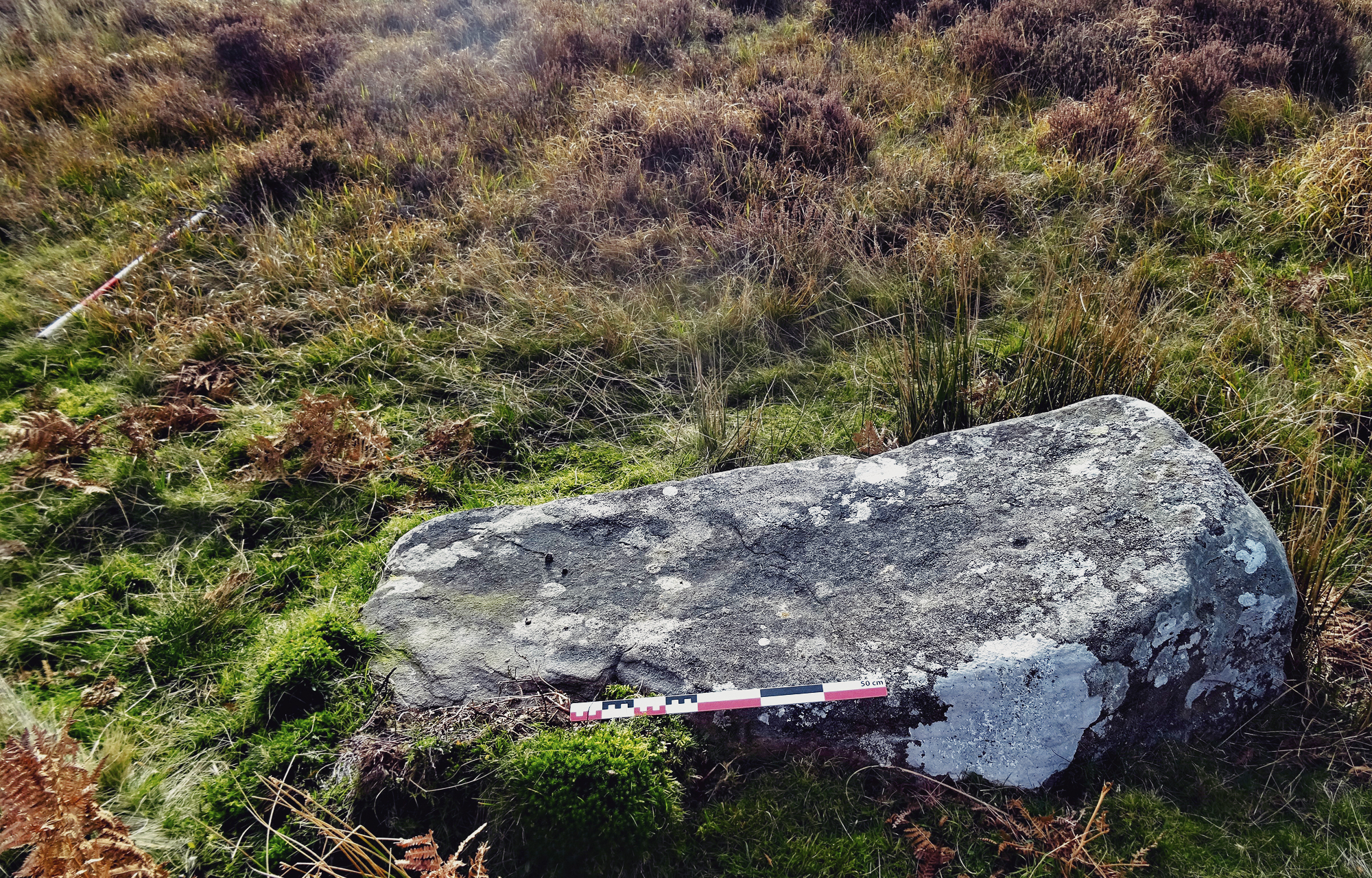
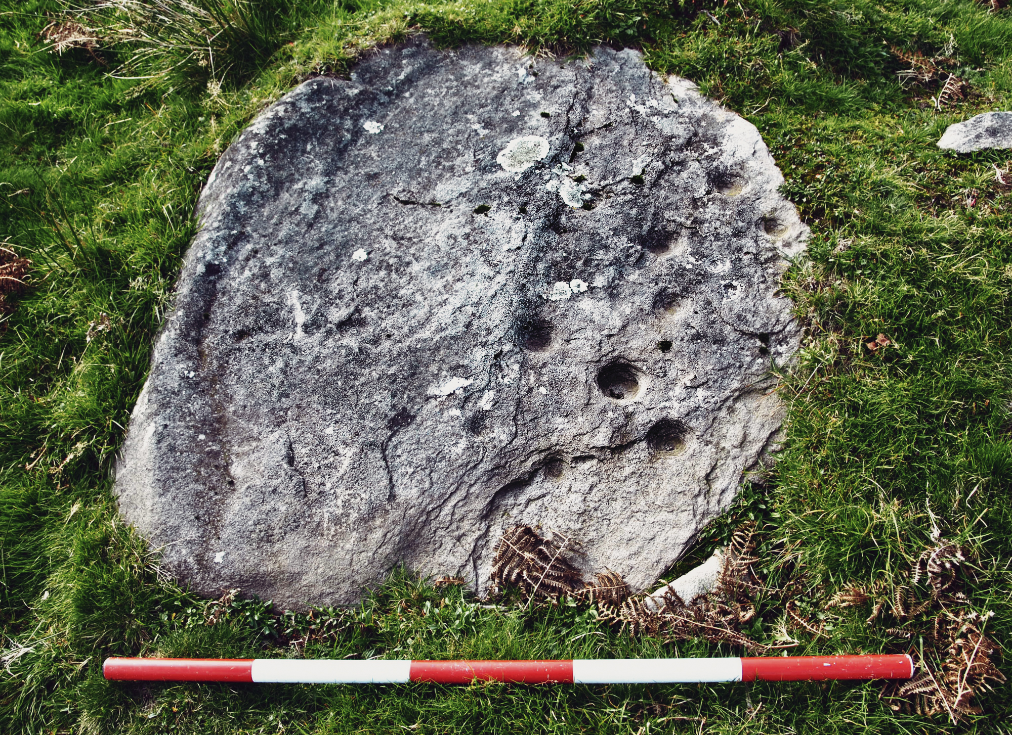
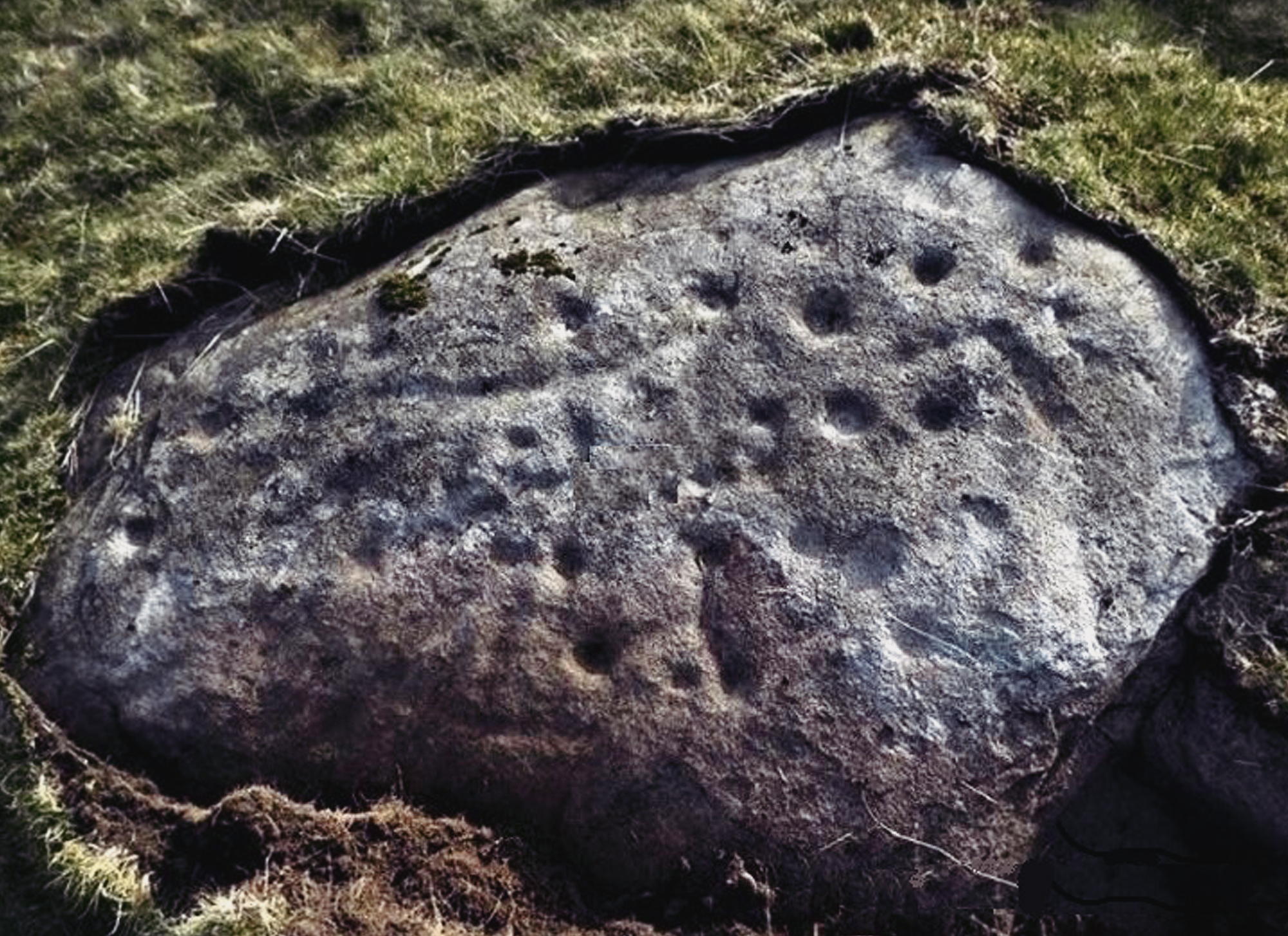
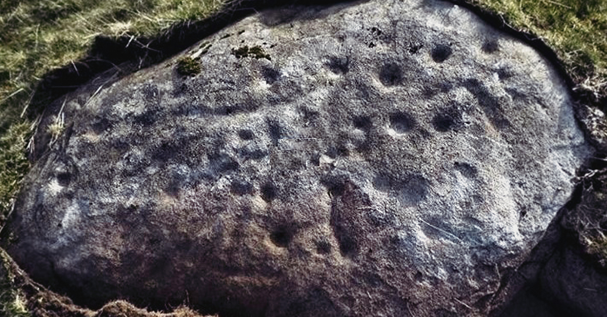
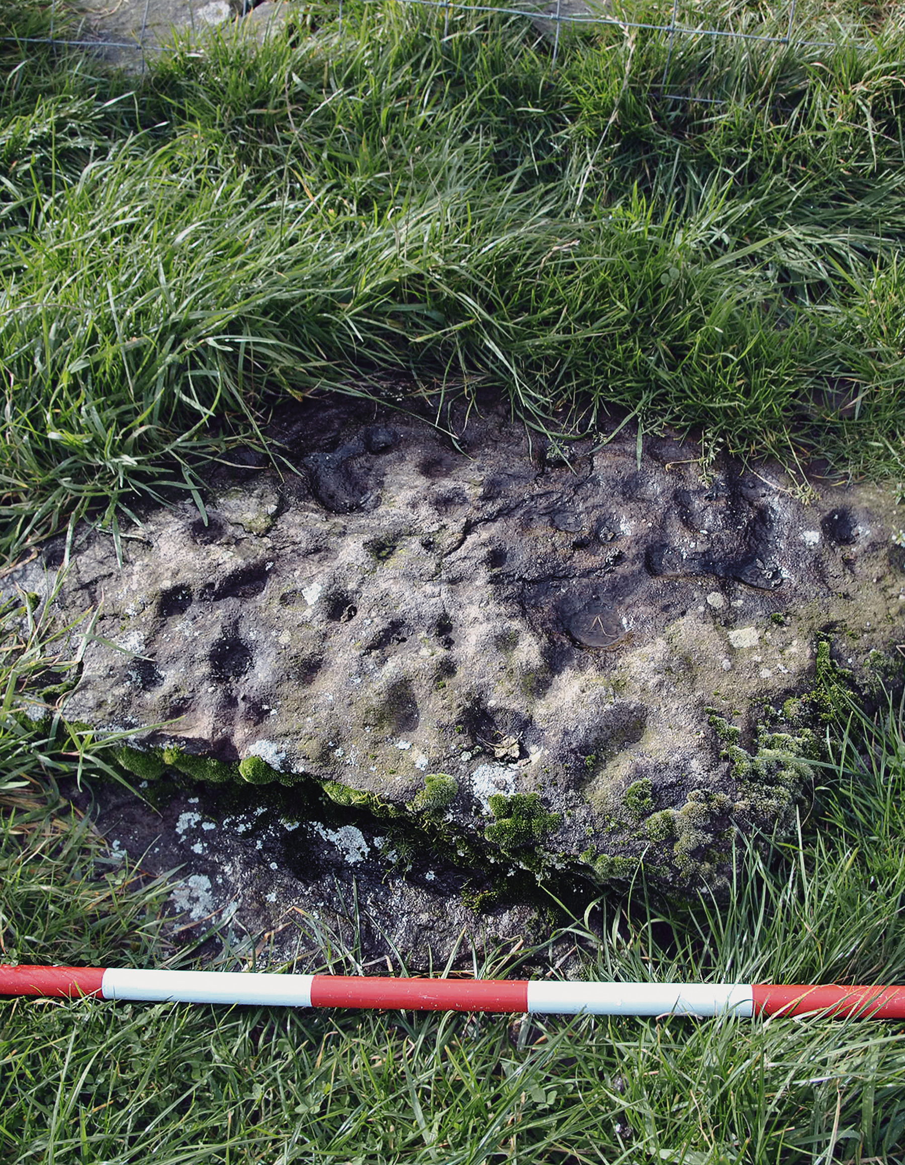
When the Royal Commission on the Ancient and Historical Monuments of Wales (RCAHMW) published its inventory for Glamorgan in 1976, only one cupmarked site was listed – a site known as Maen Catwg, near the settlement of Nelson. Maen Catwg, comprising a large single stone is located close to the village of Gelligaer and despite the lack of Neolithic activity within the locality, the authors consider the site to be a capstone that once belonged to a Neolithic or Neolithic/Early Bronze Age transitional burial-ritual monument (dated between 2500 and 1500 BCE). This large stone block, measuring 2.6m x 1.7 and containing 50+ cupmarks on its upper and side surfaces has similar affiliations with other capstones in Wales (Nash 2021). However, in terms of landscape, location and association with other Neolithic monuments, the site does not fit the criteria of belong to a Neolithic stone chambered monument Figure 2 & Figure 3.
Nearby, a similar group of monuments, several containing cupmarks have been identified on Aberdare Common, following an intense landscape survey in 2017. The common land, standing over 380m AOD is south of the town of Aberdare. Dispersed across this open marshy upland landscape is a large Bronze Age cist cemetery, organised into two distinct groups of 10 and 13 sites respectively, many of which are denuded, along with several recumbent standing stones, one of which contains a single cupmark Figure 4 & Figure 5. This now remnant prehistoric cemetery had survived later medieval and post-medieval field enclosure. Fortunately, the only farming practice within the area is the grazing of livestock.

Maen Cattwg. Capstone? with cupmarks on its upper surface

Close up view of the Maen Cattwg stone, revealing its cupmarked surface
One of a number of exposed cists on the summit of Rhos-gwawr, Aberdare
One of several recumbent standing stones the upper face containing a single cupmark
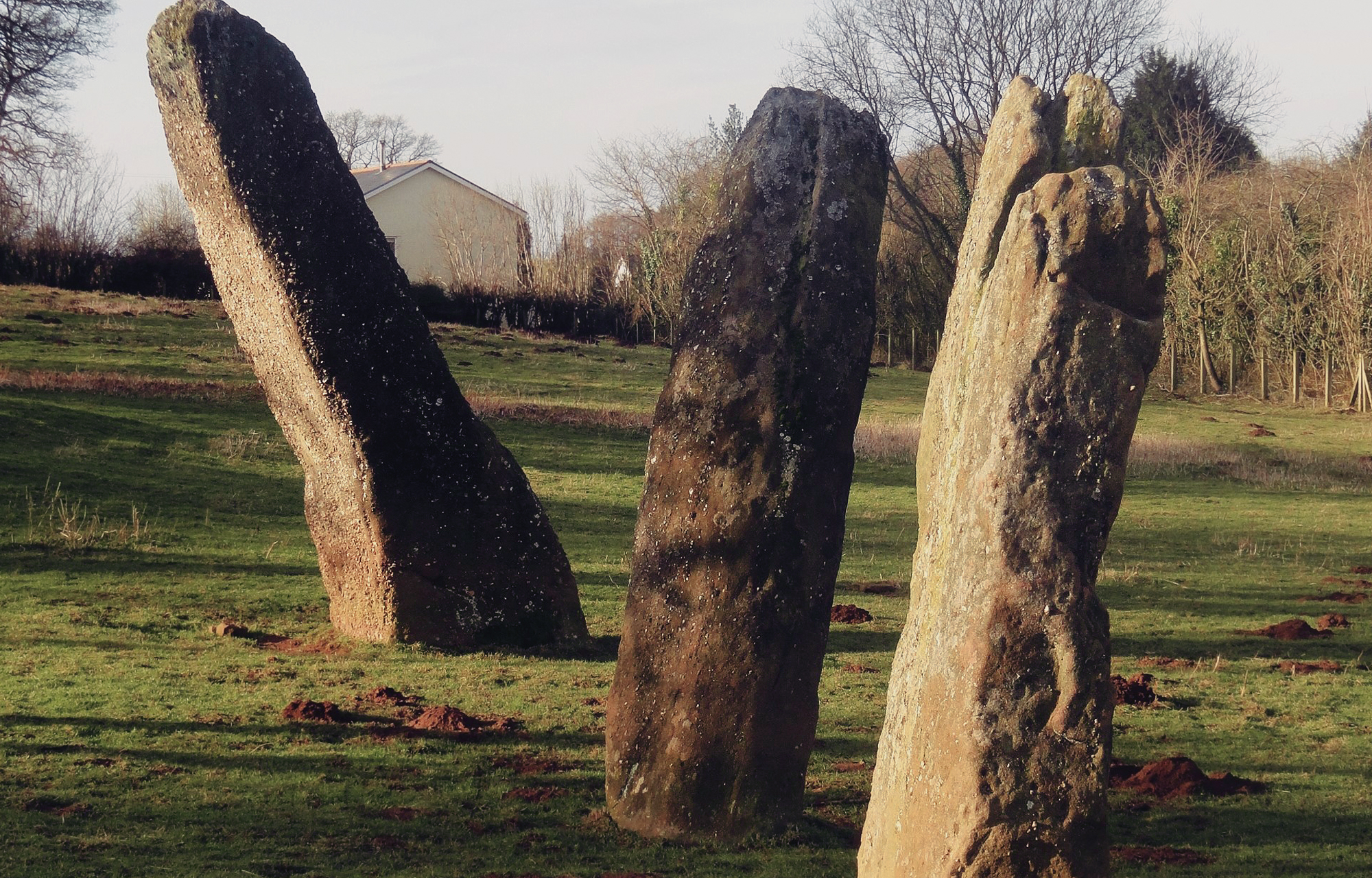
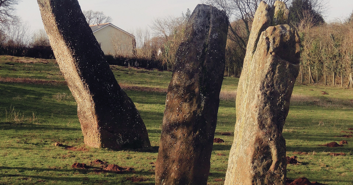
The Harold’s Stones at Trellech; the central monolith contains several cupmarks
Members of a community-led project looking at rock art on Gelligaer Common, organised by Edith Evans (GGAT)
In neighbouring Monmouthshire, only several sites were recorded in the RCAHMW inventory, including the Harold’s Stones at Trellech (Children & Nash 1996). Here, three large monoliths, located within view of the local parish church are arranged in a linear alignment, and were once thought to represent a section of a stone circle Figure 6. It is probable that further monoliths formed this significant alignment (there were at least four standing in later historical times). The central monolith, made from local sandstone conglomerate geology and standing over 2.5m high, contains a large smoothly polished cupmark on its south-east face, along with other smaller cupmarks along its shaft. Although one can suggest a rough date range of the stone alignment, it is not clear if the cupmark is contemporary or post-dates the installation of the monolith on which it is carved. It is not uncommon for rock art, especially in the form of cupmarks to be added to earlier sites such as those involved with Neolithic burial ritual activity. By adding, say, cupmarks to an existing monument, one can consider this as an act of statementing. It also intimates that the monument is multiphased and, in the case of the Harold’s Stones, the use and later reuse (statementing) may have extended over a 1500-year period.
We now turn our attention to a significant number of new discoveries which clearly show the distribution of later prehistoric rock art sites across much of the upland landscapes of South Wales. As far as we are aware, all sites are located within open upland heaths and commons, with several being incorporated into historic field boundaries. However, we stress that in all cases where engraved open-air rock art is present, so are burial-ritual and landscape monuments (Nash et al. 2024).
Since the early 2000s, Edith Evans and a community-led team have done much to record many engraved open-air sites, in particular, on Gelligaer Common, located between the settlements of Trelewis and Bargoed (Evans 2012, 2024). This large expanse of upland common land stands around 470m AOD and is littered with Bronze Age cairns (including Cairn y Burgail), medieval house platforms, tramway inclines, quarry levels, trackways and holloways. Cutting through the common from north to south is also a Roman road. Dispersed around the common is numerous rock outcropping, some of it containing single and multiple cupmarks. Based upon the distribution of these sites, there appears to be an association with a large Bronze Age cemetery which occupies the northern part of the common Figure 7 & Figure 8.
We now turn our attention to five remarkable discoveries that were made over the past four years. In 2019, two rock art panels on Eglwysilian Common, within the Nelson community were discovered and sit either side of a north-facing gully (at NGR ST 10 92). Both sites are probably contemporary and were engraved between the Early to Middle Bronze Age (c. 2500 – 1600 BCE). The motif arrangement, in the form of multiple cupmarks and lines are engraved onto two sandstone boulders (known as Ffos-yr-Haidal 1 and Ffos-yr-Haidal 2) Figure 9, Figure 10 & Figure 11. The distribution of rock art on this and other stones nearby is similar to those sites found in Northumberland and the Central Lowlands of Scotland (Morris 1989; Beckensall 1999).
The first panel is located on a slight gradient, on the east-facing side of a north-south aligned ridge overlooking the gully. The stone measures 1.3m east-west by 1.2m transversely. The panel includes at least ten cupmarks, the largest of which measures 80mm in diameter, together with several faint engraved lines. The second panel (Ffos-yr-Haidal 2) is located 220m SSE of Panel A and stands on a north-facing slope overlooking the gully. The stone is flat and measures 1.37m north-south by 0.84m transversely. The panel includes at least thirty-five cupmarks with many inter-connecting lines. The two sites, along with several stone groups were reported to Welsh heritage agency – Cadw, and as a result, both panels were Scheduled in January 2020. Their function is unknown, however, there appears to be an association with other nearby monuments, including several denuded burial cairns (Carneddi Llwydion and Cairnfield); a common association that is repeated elsewhere in the uplands of the South Wales’ Valleys region.
One of the open-air panels
on Gelligaer Common
Ffos-yr-Haidal 1, displaying
up to 10 faded cupmarks
Ffos-yr-Haidal 2, displaying around 35+
cupmarks and associated engraved lines

Ffos-yr-Haidal 2, and the
landscape in which both stones stand
The illegal excavation
of the site of Ffos-yr-Haidal 2

The Llanfabon Stone
(located along a boundary of Tai’r waun uchaf west
Despite its statutory protection in 2020, Ffos-yr-Haidal 2 and other nearby stones, was vandalised in early 2023 by a local from Abertridwr, Caerphilly Figure 12. This callous act resulted in the culprit being arrested by the police and fined £4400 and given a four-month custodial sentence, suspended for two years at Newport Magistrates Court. The incident also assisted the authorities in establishing an effective Heritage Crime Unit in South Wales.

Night image showing the wealth of cupmarks on the eastern side of the stone
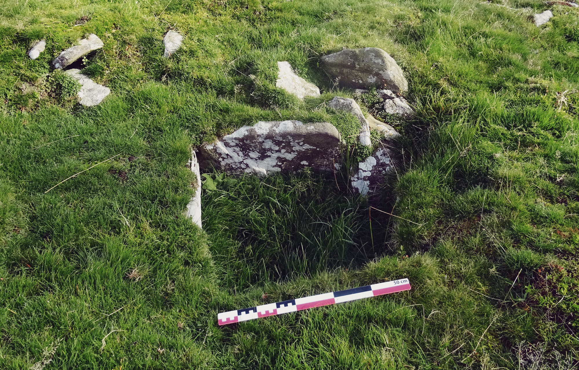
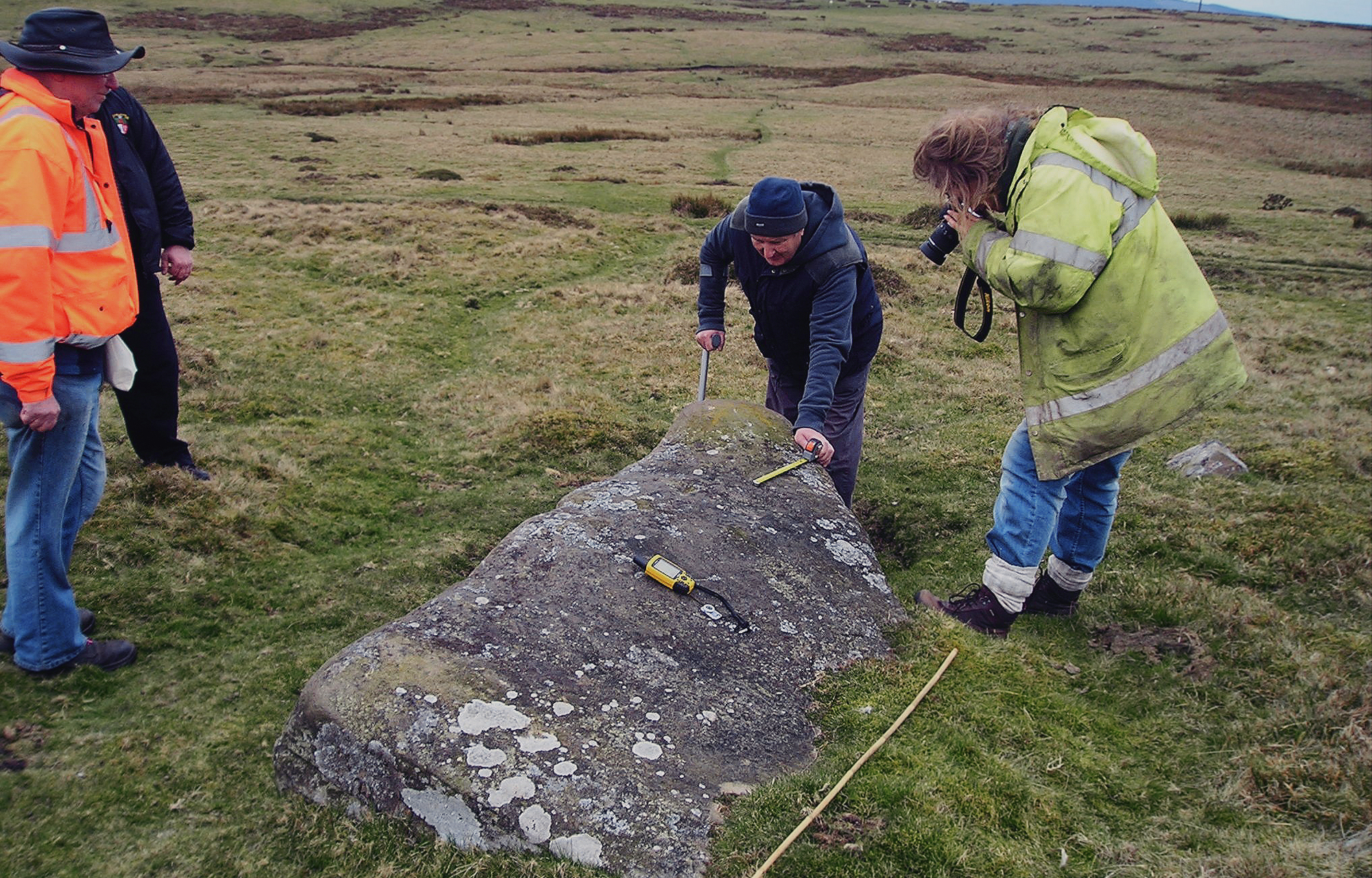
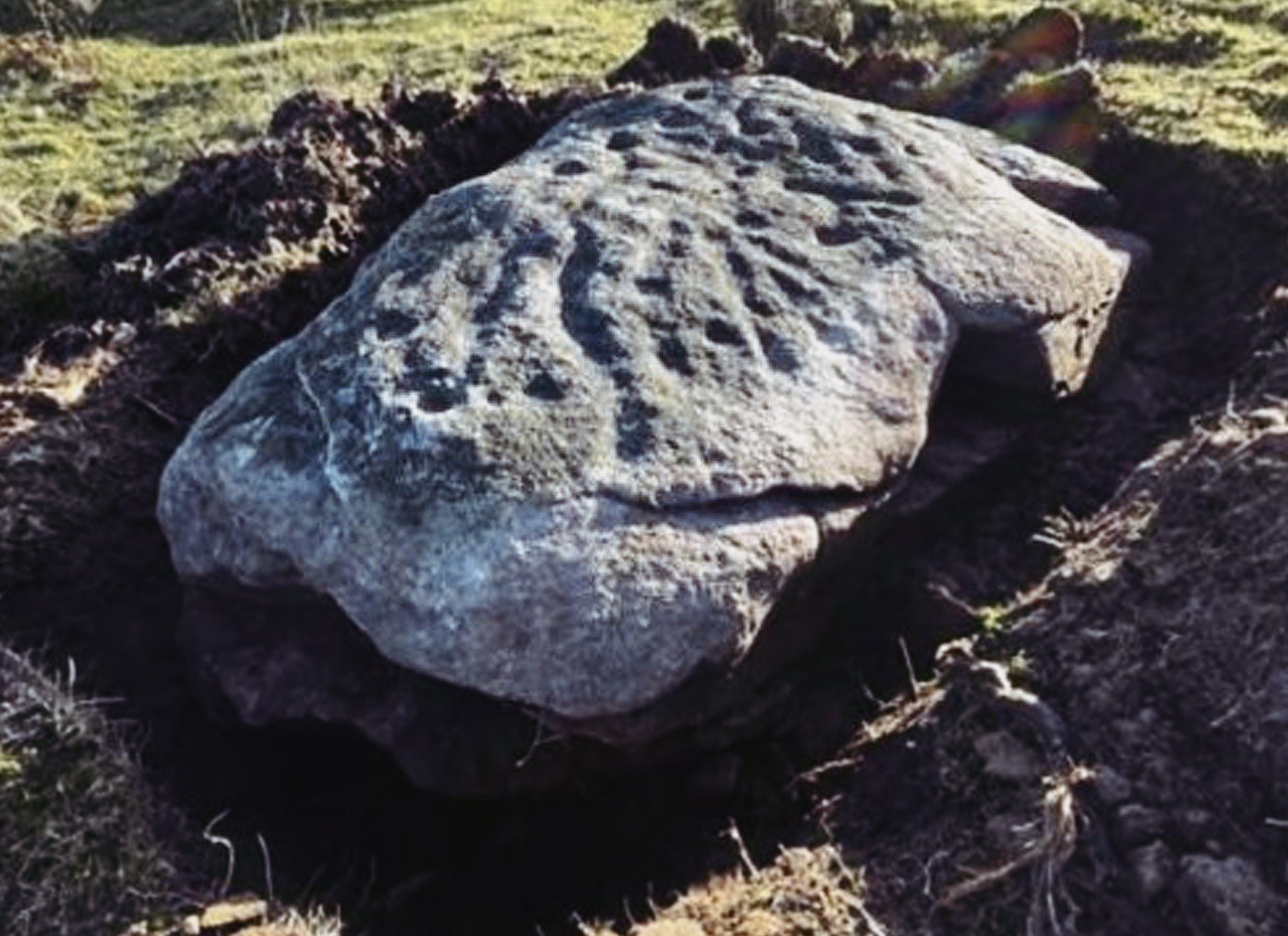
Inspection of the base of the stone (especially around its NW section), revealed that it is probably detached from the underlying bedrock, suggesting it is a glacial erratic that has been moved into its current position (i.e., strategically overlooking a steep sided valley). However, surrounding the stone is a subtle undulating surface that contains the possible remnants of an ovate cairn mound. Remnants of this feature exist around the western side of the stone and along the linear boundary and have been probably re-deposited in this area in order to improve the agricultural quality of the field. Incorporated into the linear boundary are several larger stones/boulders which may be associated with the monument. It is considered that the faint remains of the mound, measuring up to 14 m (N-S) by 8m (E-W) may be associated with the cupmarked stone, intermating the remains of a Neolithic or Neolithic-Bronze Age transition burial-ritual monument (Nash et al. 2024). However, a geophysical survey undertaken in 2022 proved inconclusive.
In terms of an interpretation, the boulder does slope to the south towards Eglwysilan Common, where the nearby cup marked stones of Ffos-yr-Haidal 1 and 2 are located, immediately over the ridge line (see below). While there is no intervisibility with these engraved boulders, there is, however, an earthen/cairn mound and an assemblage of loose stone and boulders that stand close by, which are visible along the ridge-line, when viewed from the Llanfabon Stone. The proximity of the two cup marked stones on Eglwysilan Common, while not intervisible with the Llanfabon Stone may indicate some association, such as a ritualised processional route way between the two monument groups, using the ridge-line markers as a visual guide.
A large boulder to the north of the Llanfabon stone, has similar weathered laminated geology perhaps indicating that it was once a part of the larger boulder that was reduced in size at a later date to improve agricultural use of the field in which both stones stand. There are also many large stones in the surrounding fields; some of these may have been used in the construction of farm buildings and trackways. It could be the case that during historic times, further monuments may have been disassembled or destroyed and reused.
To the northwest of the Llanfabon Stone, on land currently owned by National Grid (the Cilfynydd substation) is the source of the Nant ddu, which flows to the west in a southerly direction. It is within this area of the landscape that further monuments that were associated with the Llanfabon Stone may have stood. The confluence of the Nant ddu with the Nant Cae dudwg to the southwest of the stone may give greater meaning as to why this was an important area given the significance of water sources and confluences. We should note that geo-prospection of this area is ongoing.
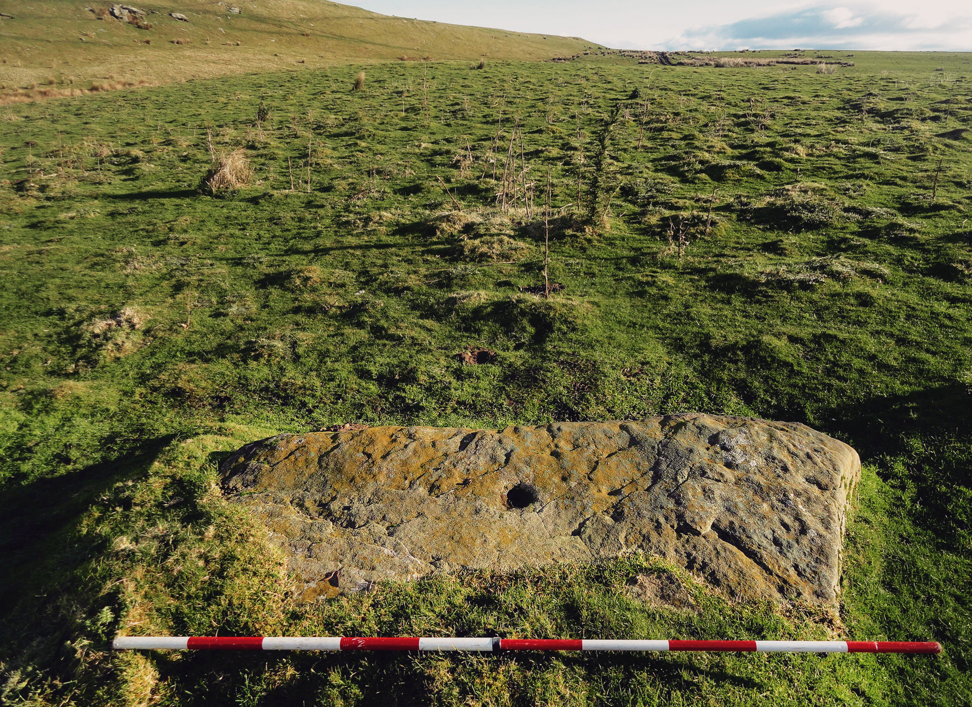
Finally, in late October 2023, the team assembled above the Vale of Neath and explored the open upland landscape of Mynydd Drumau, above the eastern side of the village of Skewen. Mynydd Drumau rises to a height of 260m above the Neath Valley and has extensive views to the south and east. The upland landscape has, in its historical past been enclosed by drystone walled fields and a substantial holloway that occupies the eastern ridge of the mountain. Also present are the ruins of a farmstead that lies west of Darran Wood. As far as we were aware, only one of these rock art sites [labelled RA2] was known about (recorded on social media by Paul Blades). Within this historically altered upland landscape were six prehistoric sites, three of which do not appear on the regional Historic Environment Record database and Archwilio, including the two rock art sites.
The most visual of the known archaeology is the Scheduled Monument of Careg Bica Standing Stone (located at NGR SS 72499 99603) (SM: GM382) Figure 15. This imposing monolith, standing around 4m in height appears to be a major focal point within this remnant prehistoric landscape. Approximately c.50m to the north of Careg Bica are the remains of a Bronze Age cairn (formed as a concentrated rubble spread), while 300m to the south are a further two cairns that retain their architectural traits, including their circular cairns. The rock art sites (RA 1 [NGR SS 72 98] Figure 16 and RA2 [NGR SS 72 98]) Figure 17 stand either side of the monolith, to the north and south. It should be noted that what we may be looking at is a remnant later prehistoric landscape with the Careg Bica Standing Stone at its central [focal] point. One of the rock art sites is incorporated into an historic field boundary, while the other is in a large open field, forming the remains of a former burial-ritual cairn of Bronze Age date. It is probable that this upland area formed a complex ritualised landscape, much of it falling victim to later landscape changes during historical times. Following our visit, both sites were reported to Cadw, with a view of getting both designated Scheduled Monuments.
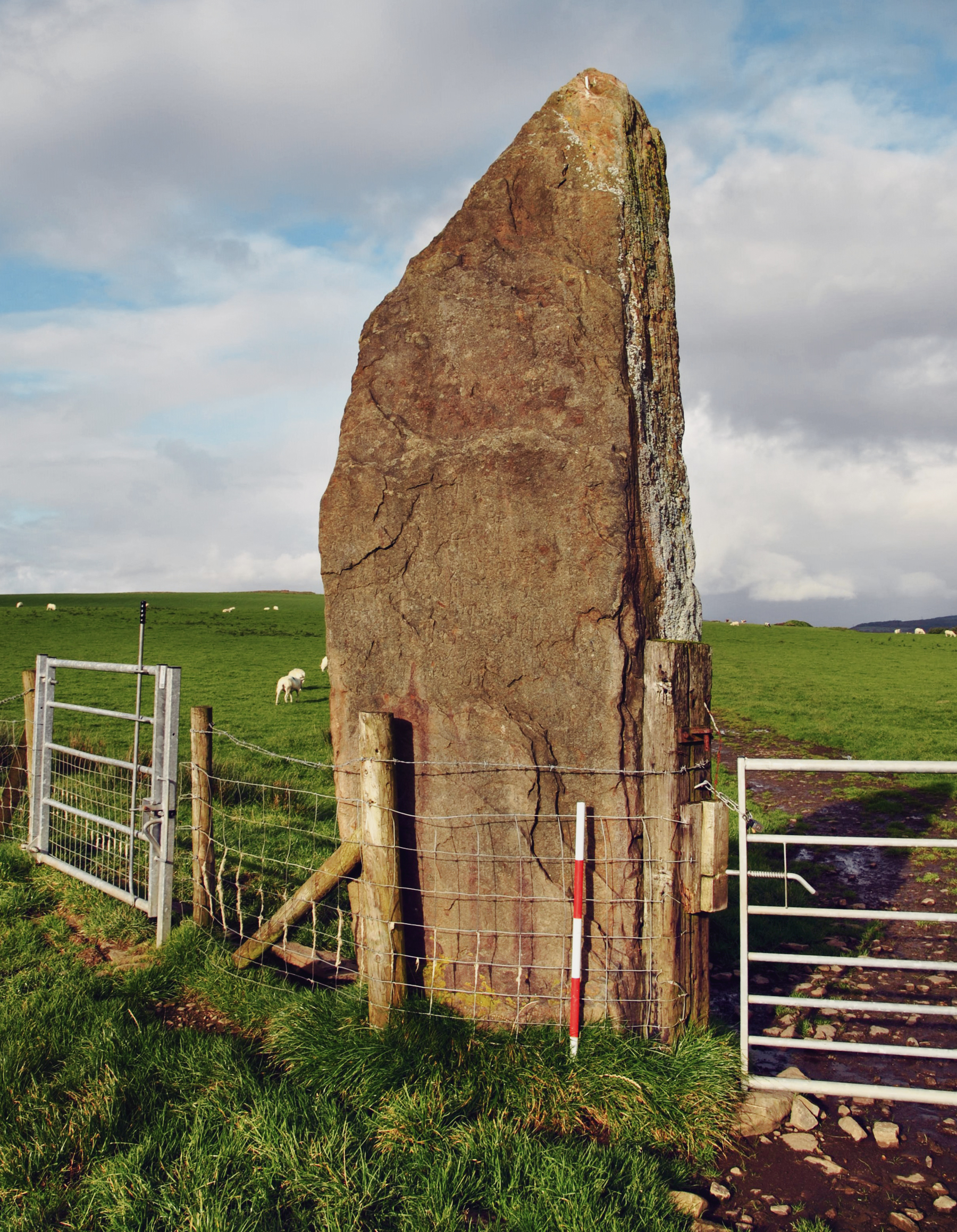
The main focal point of the upland landscape overlooking the Vale of Neath: Careg Bica

Site RA 2, standing to the north of the giant monolith, Careg Bica

Site RA1, incorporated into a drystone walled field boundary and standing east of a large Bronze Age burial-ritual cairn
The main focal point of the upland landscape overlooking the Vale of Neath: Careg Bica
Figure 16 (center)
Site RA 2, standing to the north of the giant monolith, Careg Bica
Figure 17 (right)
Site RA1, incorporated into a drystone walled field boundary and standing east of a large Bronze Age burial-ritual cairn
Between now and when these rocks were being decorated with cupmarks, represents at least 180 generations of community (or around 4500 years ago). Unfortunately, during this 4000-year period, the meaning of what engraved cupmarks and other motifs has been lost. We can make some inferences by looking at the distribution of openair rock art sites with other stone monuments that survive the archaeological record, in particular, Neolithic and Bronze Age burial ritual sites that occupy the same landscapes, along with landscape monuments such as standing stones, stone circles and stone rows; all of which frequent the upland landscape of South Wales. As noted in the Scheduling text made by Cadw, there is a possibility that engraved rock outcropping, such as the multiple sites on Gelligaer Common or the two sites on Eglwysilian Common represent landscape markers, whereby local prehistoric communities could approach a burial-ritual monument in a proscribed way (see also Children & Nash 1996, Nash et al. 2012). However, what the cupmarks mean and how they were arranged remains a complete mystery, although we consider the idea that when illuminated by either a setting sun or the rising moon, or by ancient torches, multiple cupmarks may have represented celestial bodies such as stars and planets. The large sandstone boulder at Llanfabon with its 93+ cupmarks may have represented a bright and clear account of the cosmos, say 4500 years ago. Alternatively, each cupmark could have represented a deceased individual who was ceremoniously paraded using a designated corpse road to his or her final resting place. Who knows? The interpretations are potentially infinite!
It is clear from the desk-based research and fieldwork undertaken by our group and a sound baseline of research undertaken by scholars such as Edith Evans (2012) and Nash et al. (2024), that the uplands of South Wales remain a potential focus for further discovery. It should be noted that the humble cupmark is not just found in Wales but is an archaeological phenomenon that extends across much of Atlantic and Mediterranean Europe (e.g., Morris 1989; Nash 2021). This motif is usually associated with identical monuments and locations that are akin to South Wales. It is conceivable that engraved rock art can be chronologically-phased; from attached to burial-ritual monuments in the Neolithic to landscape monuments during the Bronze Age. During the transition phase between the two periods (c. 2500 BCE), both rock art groups would have been in use.
One can suggest that this simple engraved motif is central to European identity, of which the Neolithic and Bronze Age communities of Wales formed an essential part of. The meaning of the humble cupmark and how it interacts with other motifs could have had universal meaning over a landmass that extended 3200 km, from the Iberian Peninsula to Southern Scandinavia, along the aptly named Atlantic Façade.
Beckensall, S., 1999. British Prehistoric Rock Art, Stroud, Tempus.
Bowen, D., & Pritchard, O., 2023. Hunting the Wild Megalith: Following the trail of the Arthurian boar hunt through South Wales.
Bradley, R., 1998. The Significance of Monuments London: Routledge.
Bradley, R., 2002. The Past in Prehistoric Societies London: Routledge.
Children, G., and Nash, G.H., 1996. Prehistoric Sites of Monmouthshire, Woonton Almeley, Longston Press.
Daniel, G.E., 1950. The Prehistoric Chambered Tombs of England and Wales, Cambridge, Cambridge University Press.
Evans, E.M., 2012. Gelligaer Common Community Prehistoric Rock Art Survey (GGAT unpublished report 2013/018.
Evans, E.M., 2022. Prehistoric Rock Art in Glamorgan and Gwent. In A. Mazel & G.H. Nash (eds.). Signalling and Performance: Ancient Rock Art in Britain and Ireland. Oxford: Archaeopress, pp. 316-31.
Fox, C., 1959. Life and Death in the Bronze Age. London: Routledge and Kegan Paul.
Mazel, A. & Nash, G.H., 2022. Signalling and Performance: Ancient Rock Art in Britain and Ireland. Oxford: Archaeopress.
Morris, R.W.B., 1989. The Prehistoric Rock Art of Great Britain: a survey of all sites bearing motifs more complex than simple cup-marks, Proceedings of the Prehistoric Society 55, 48–88.
Nash, G.H., 2006. The Architecture of Death: Neolithic chambered tombs in Wales. Hereford: Logaston Press.
Nash, G.H., 2021. Contextualising megalithic rock art on Neolithic chambered tombs: a Welsh perspective, In C Charette, A Mazel and G H Nash (eds.) Indigenous Heritage and Rock Art: Worldwide Research in Memory of Daniel Arsenault, Oxford: Archaeopress, 14-31.
Nash, G.H., 2023. Discovery of a Cupmarked Stone on The Boundary of Tai’r Waun Isaf and Tai’r Waun Uchaf, Llanfabon, Mid-Glamorgan (NGR SS 10220 93489). Archaeology in Wales, Vol. 61, 3-6.
Nash. G.H., Allen, K. & Bowen, D., 2024. Documenting a sacred landscape: Rock art and monuments in the South Wales uplands. Current Archaeology, Issue 410, 42-46.
Nash, G.H., Brook, C., George, A., Hudson, D., McQueen, E., Parker, C., Stanford, A., Smith, A., Swan, J. and Waite, L., 2005. Notes on Newly Discovered Rock Art on and round Neolithic Burial Chambers in Wales, Archaeology in Wales, 45, 11-16.
Nash, G.H., Stanford, A., Therriault, I.& Wellicome, T., 2012. Transcending Ritual Boundaries, From Dolmen to Menhir: The Excavation of the Trefael Stone, Southwest Wales. Archaeology in Wales Vol. 51, 51-61.
RCAHMW, 1976. An Inventory of the Ancient Monuments in Glamorgan. Vol. 1, Part 1 Stone and Bronze Age. London HMSO.
Savory, H.N., 1940. Middle Bronze Age barrow at Crick, Monmouthshire. Archaeologia Cambrensis, 95, 169-91.
Sharkey, J., 2004. The Meetings of the Tracks: Rock art in Ancient Wales. Llanrwst: Carreg Gwalch.
Simpson, J.Y., 1867. i>On Archaic Sculpturings of Cups, Circles, Etc. Upon Stones and Rocks in Scotland, England and Other Countries, Alnwick.
→ Subscribe free to the Bradshaw Foundation YouTube Channel
→ British Isles Prehistory Archive
→ British Isles Introduction
→ Stonehenge
→ Avebury
→ Kilmartin Valley
→ The Rock Art of Northumberland
→ Rock Art on the Gower Peninsula
→ New rock art discoveries in the Peak District National Park
→ Painting the Past
→ Church Hole - Creswell Crags
→ Signalling and Performance
→ Cups and Cairns
→ Ynys Môn, North Wales
→ Bryn Celli Ddu
→ Remembering Stan Beckensall
→ The Prehistory of the Mendip Hills
→ The Red Lady of Paviland
→ Megaliths of the British Isles
→ Stone Age Mammoth Abattoir
→ Bradshaw Foundation
→ Rock Art Network


