
As Dr. Quinlan and his colleagues at the Nevada Rock Art Foundation state, 'The ancient people of North America left no written records of their cultures. For us to gain an understanding of what happened here in ancient times, we rely on clues these early Americans left behind in the remains of their villages, monuments, and artifacts. Rock art is one of the most ubiquitous records of past human action. Archaeologists still lack the clues that might someday solve the mysteries of the first Americans. By permanently preserving and recording important cultural sites, the Nevada Rock Art Foundation makes sure they will be available for all.' It is for this reason that the Bradshaw Foundation wishes to support and publicise the on-going research of the Nevada Rock Art Foundation.
The Nevada Rock Art Foundation of North America is a non-profit 501(c)(3) organization that actively promotes the protection and public awareness of rock art in Nevada and surrounding areas. The mission of the Foundation is to identify, document, preserve, and protect rock art. These sites contain images of great beauty and artistic merit and are often located in spectacular landscapes. The original cultural significance of this ancient art made by Nevada's prehistoric and historic peoples is poorly understood, though most theories concur that this art reflects the rituals, beliefs and practices of its makers.
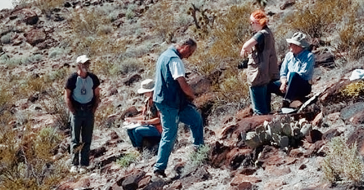
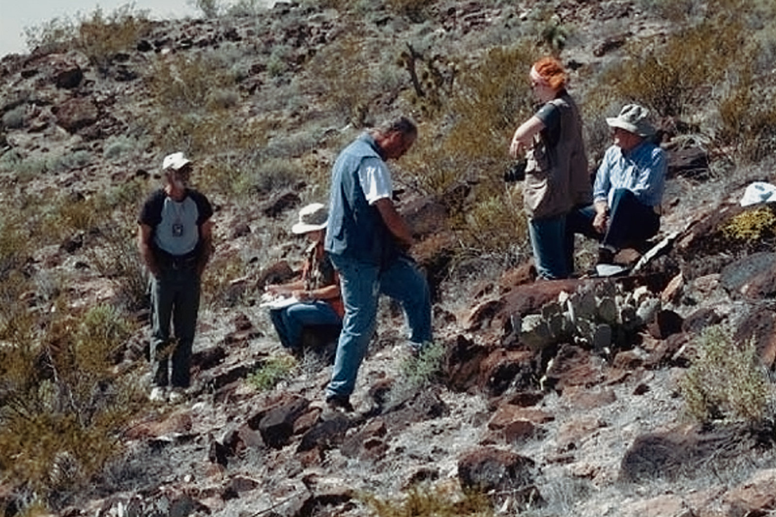
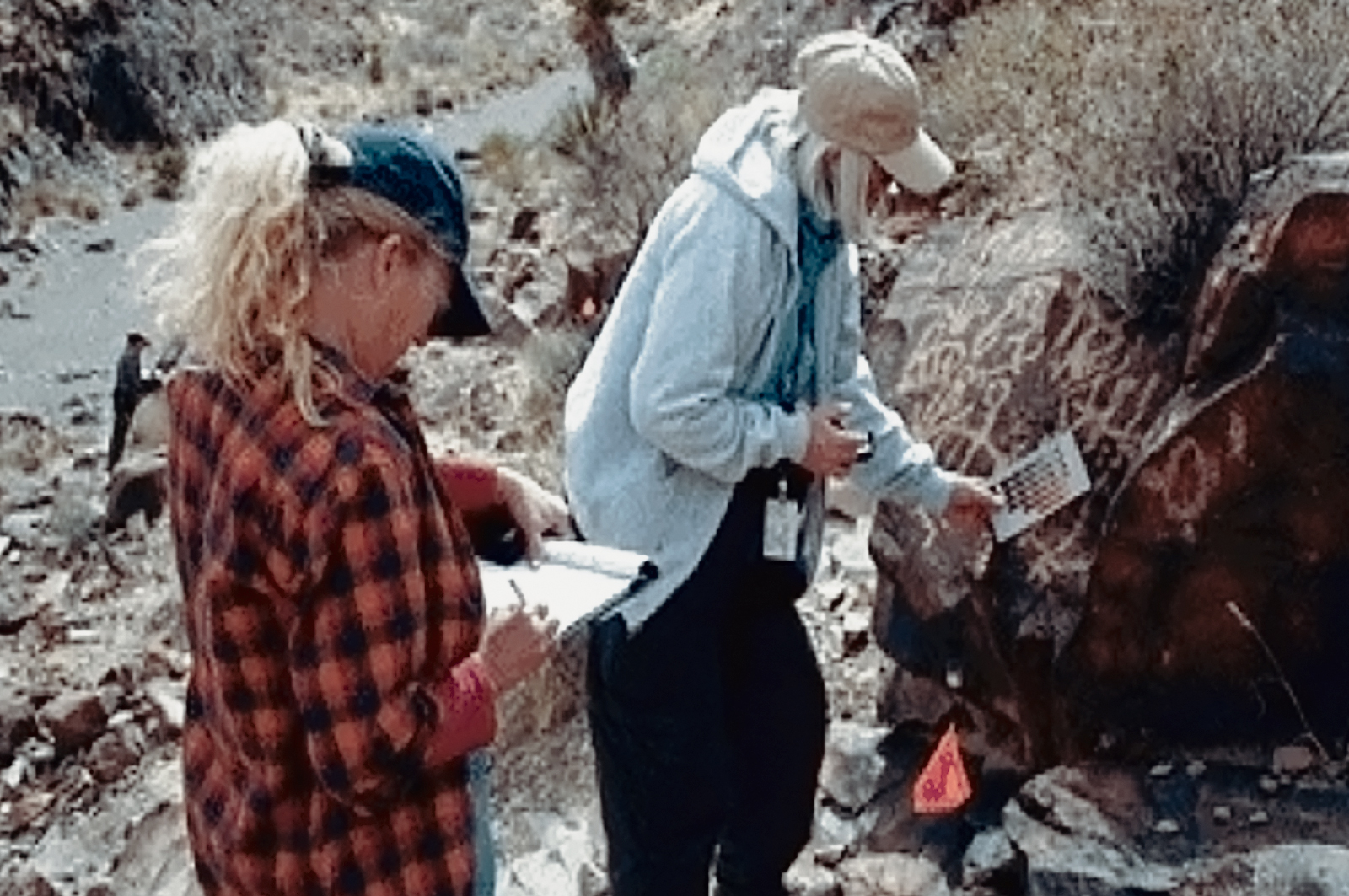
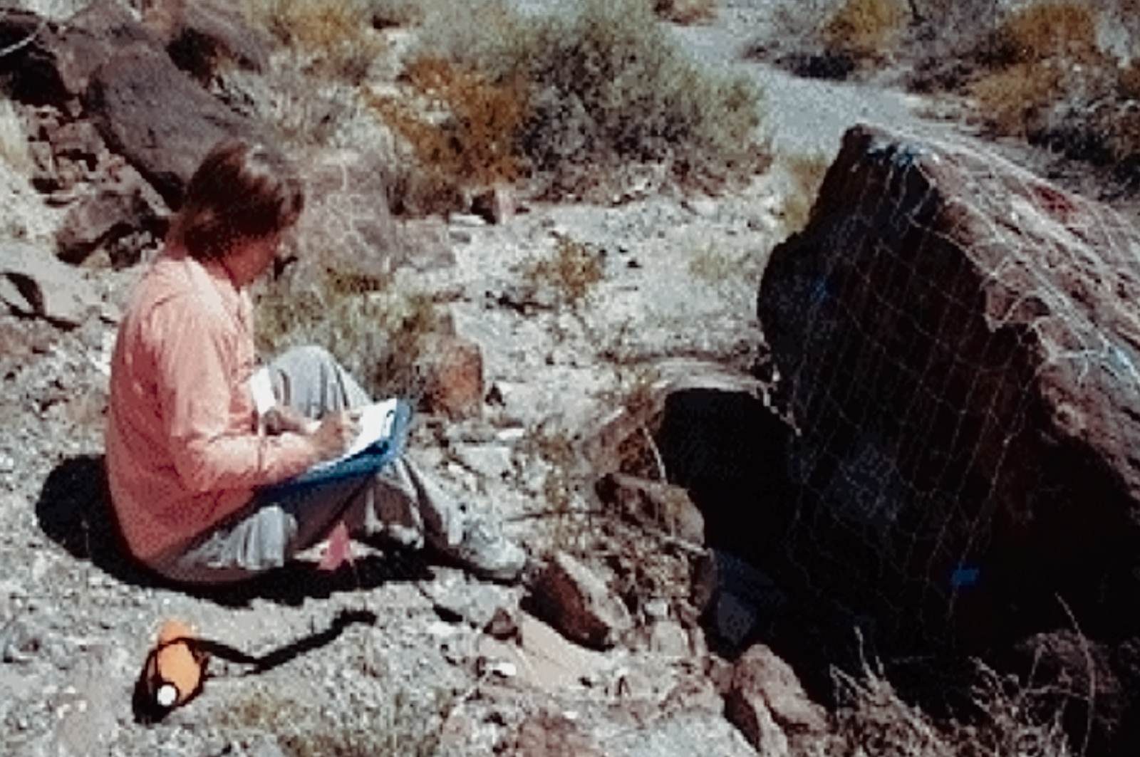
The Nevada Rock Art Foundation implements its mission through programs of site documentation and public education. Our fieldwork is carried out by volunteers certified through our rock art documentation program and supervised in the field by a staff archaeologist. We have built strategic partnerships with federal and state land managing agencies and have recorded important rock art sites throughout Nevada, USA.
Through education programs we promote public awareness and appreciation of the heritage significance of Nevada rock art and other archaeological resources. Active research and professional publications allows the heritage significance of Nevada's rock art to be brought to the attention of a wider audience.
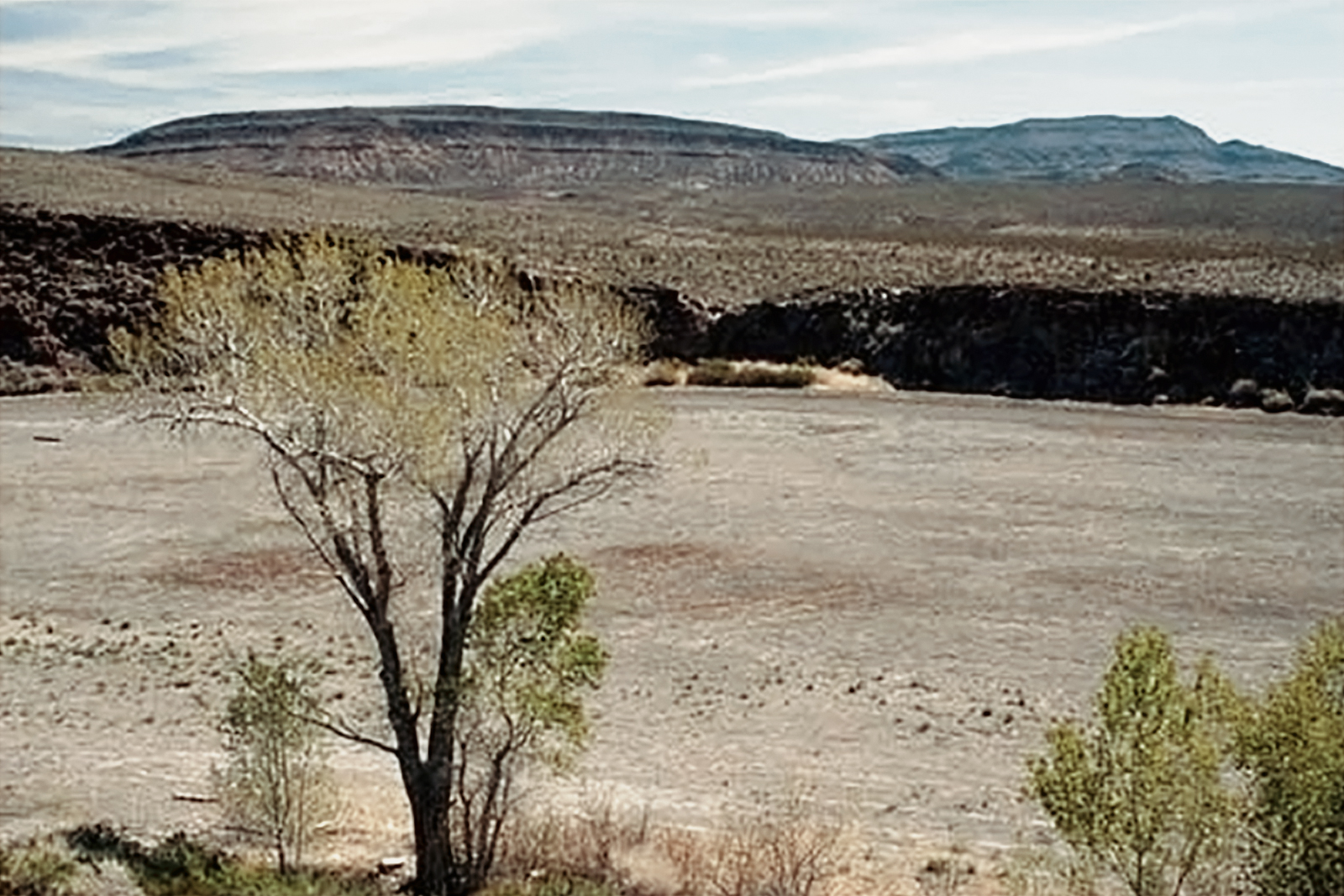
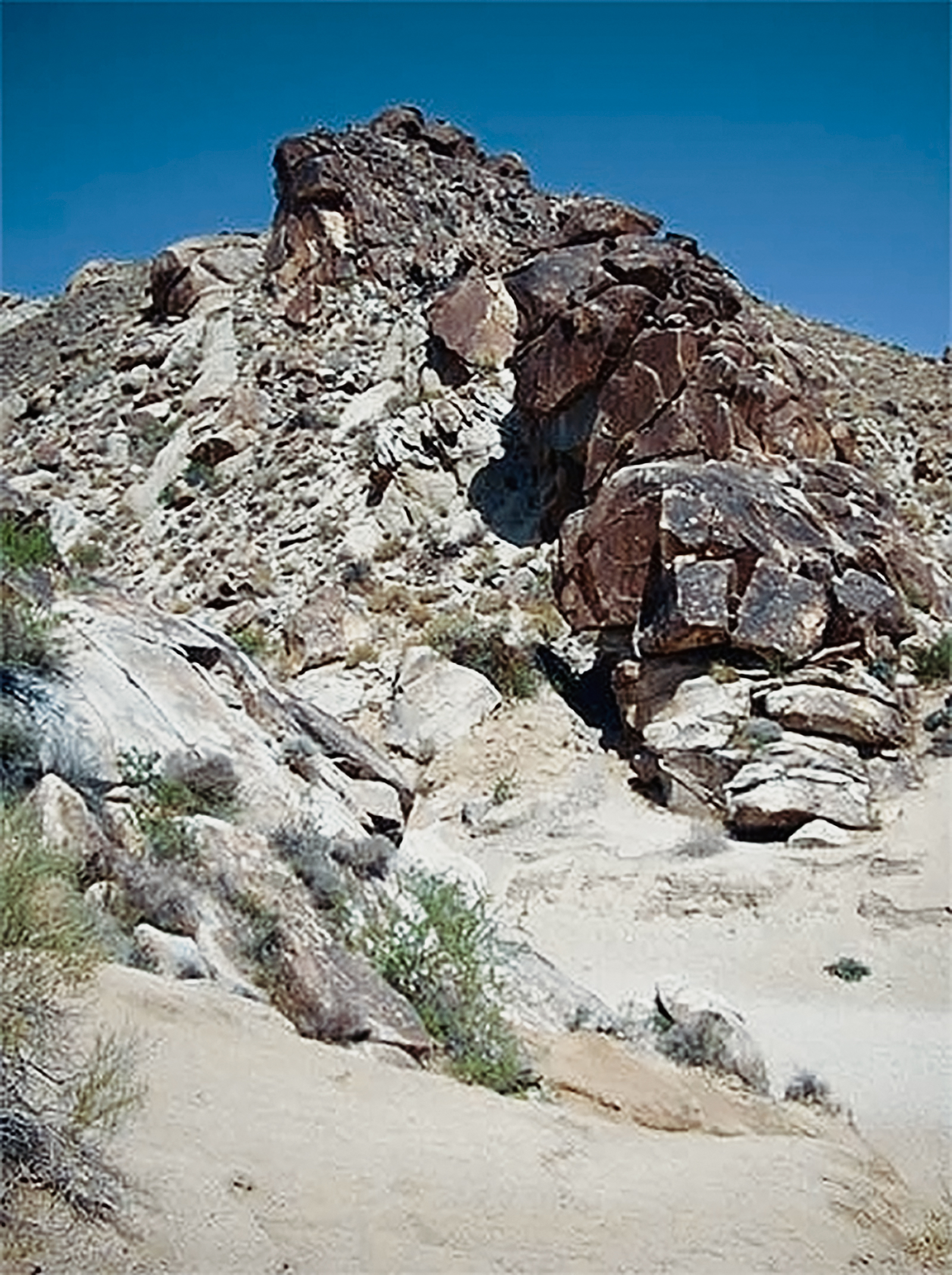
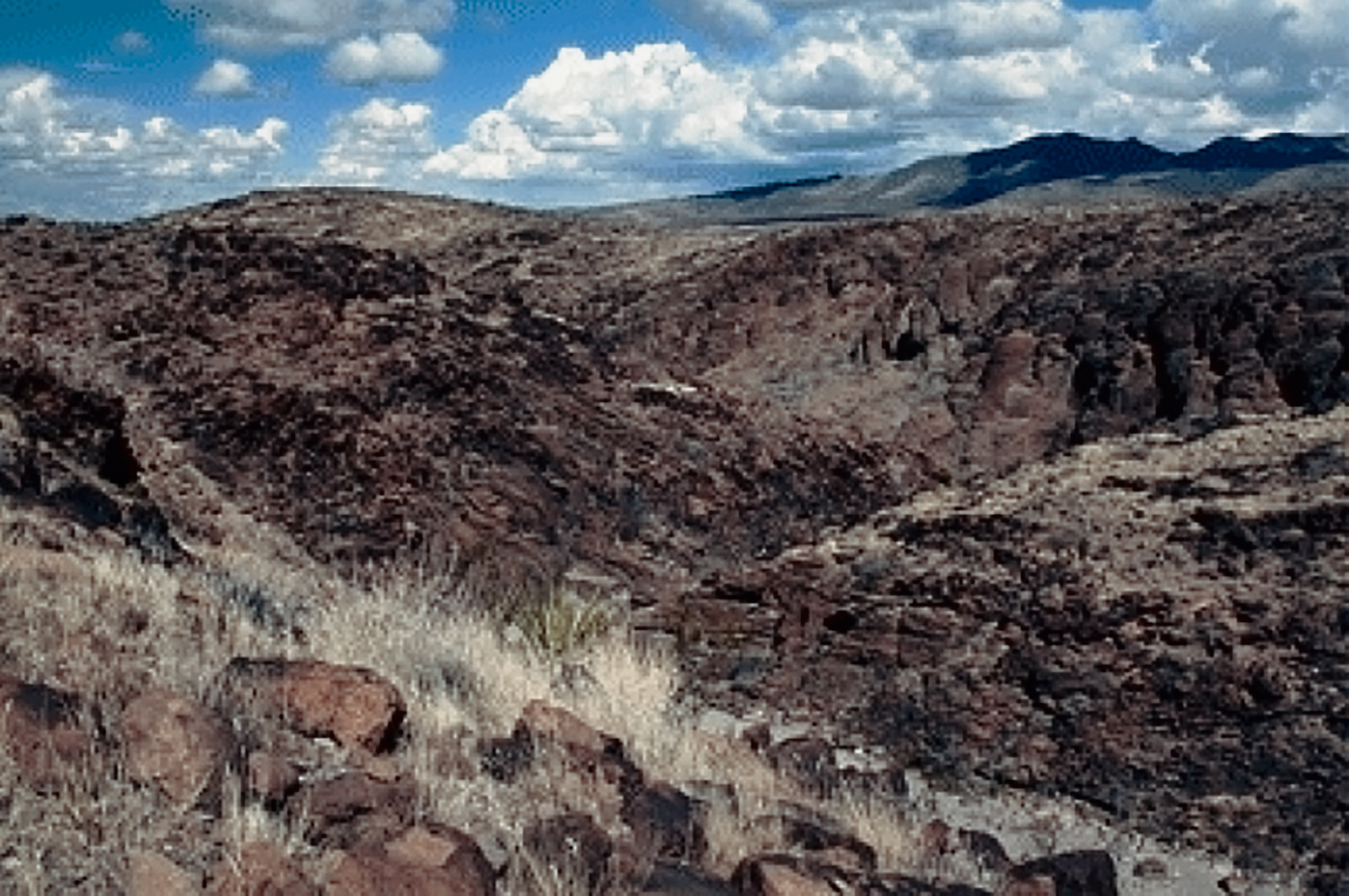
The archaeological signifi cance of Black Canyon was recognized in the 1970's with its listing on the National Register of Historic Places as an archaeological district. The US Fish and Wildlife Service contracted Far Western to complete an intensive archaeological survey and recording of Black Canyon to provide data that would serve as the basis for future management, conservation, and interpretation of the district's unique cultural resources. The rich natural resources in this area appear to have been intensively used in prehistory, reflected by the abundant rock art and other archaeological features. Black Canyon also probably served as a transportation corridor for peoples moving between the upper reaches of the White River and the marshes of Lower Pahranagat valley.
Recording Black Canyon
Rock Art Styles at Black Canyon
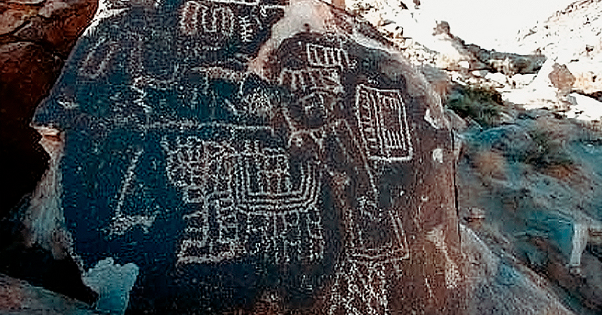
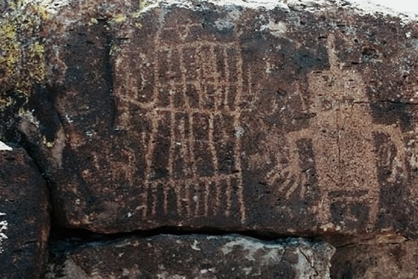
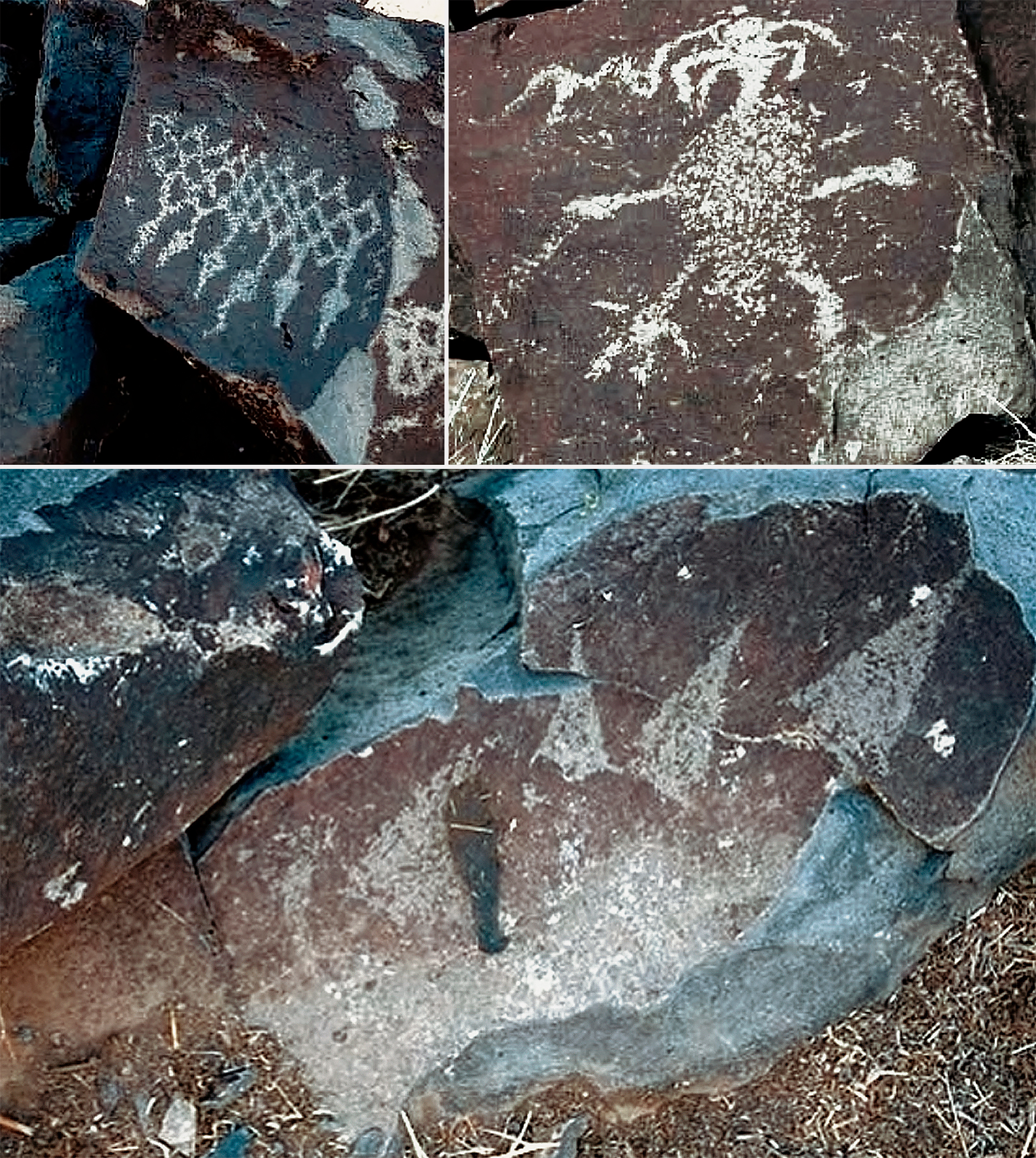
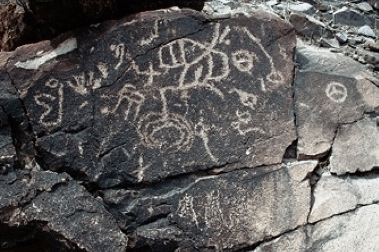
Black Canyon is well-known for its concentration of Pahranagat Representational Style petroglyphs. This distinctive style is composed of varying treatments of the human form: a headless rectangular form with internal decoration, often bearing an atlatl-like design, and a solid-pecked oval or rectangular form, with a line protruding from the head and with down-turned arms and extended hands.
Acknowledgements
We are grateful to the US Fish & Wildlife Service and Far Western Anthropological Research Group for the opportunity of participating in this project. Nevada Rock Art Foundation volunteers were directed in the field by Angus Quinlan, assisted by Kasey O’Horo and Sarah Henderson. Susan Bailey, Carolyn Barnes-Wolfe, Ralph Bennett, Janice Hoke, Elaine Holmes, Bill James, Joan Johnson, Rose Keough, Cornelia and Maury Kallerud, Ed Laine, Anne McConnell, Deb and John Mitchell, Geno Oliver, Paula Reynosa, Sue Roberts, Doug Rorer, Margaret Westcamp, and Alison Youngs braved the elements and difficult terrain, working diligently at all times; their hard work and dedication are greatly appreciated.
In November and early December 2009, the Nevada Rock Art Foundation worked with the National Park Service Lake Mead Recreation Area to record Grapevine Canyon, one of the most important rock art sites in southern Nevada. The purpose of this project was to provide the National Park Service (nps) with accurate and up to date information about the site’s condition, characteristics, and spatial extent.
The project also provided training in rock art documentation methods to site stewards in the Clark County Cultural Heritage program, who strongly supported the project in the field. Grapevine Canyon receives regular public visitation and the results of the documentation project help the National Park Service’s management and public interpretation of the site, as well as enhance the effectiveness of its monitoring program.
Grapevine Canyon was first described in the archaeological literature by Julian Steward in the late 1920s. The site has played a signifi cant role in stylistic research on Great Basin rock art but needed an up-to-date archaeological inventory to better assist the management needs of the National Park Service. The site has been argued to be the type site of the Grapevine Canyon style (formerly known as the Colorado River style) (Christensen & Dickey 2001), a distinctive style associated with the Patayan Culture. The Grapevine Canyon style is concentrated along the drainage of the Colorado River, and its style traits exhibit an emphasis on rectilinear, symmetrical and geometric design forms. This style can be viewed as an east Mojave variant of the Basin and Range Tradition rectilinear designs, or as its own style associated with the Patayan and Yuman groups.
Grapevine Canyon's rock art is characterized by prominent designs that are striking for their care of execution, size, complexity, and visual impact. Very large abstract designs dominate the site, often densely packed, on large boulder surfaces and canyon walls. Distinctive design types, including "I" shapes, denticulated lines, "H"-like motifs, and rectangles internally decorated with intricate rectilinear elements, are repeated across the site and placed in striking locations that are highly public and visible. The use of negative space to form many of these designs is particularly noteworthy.
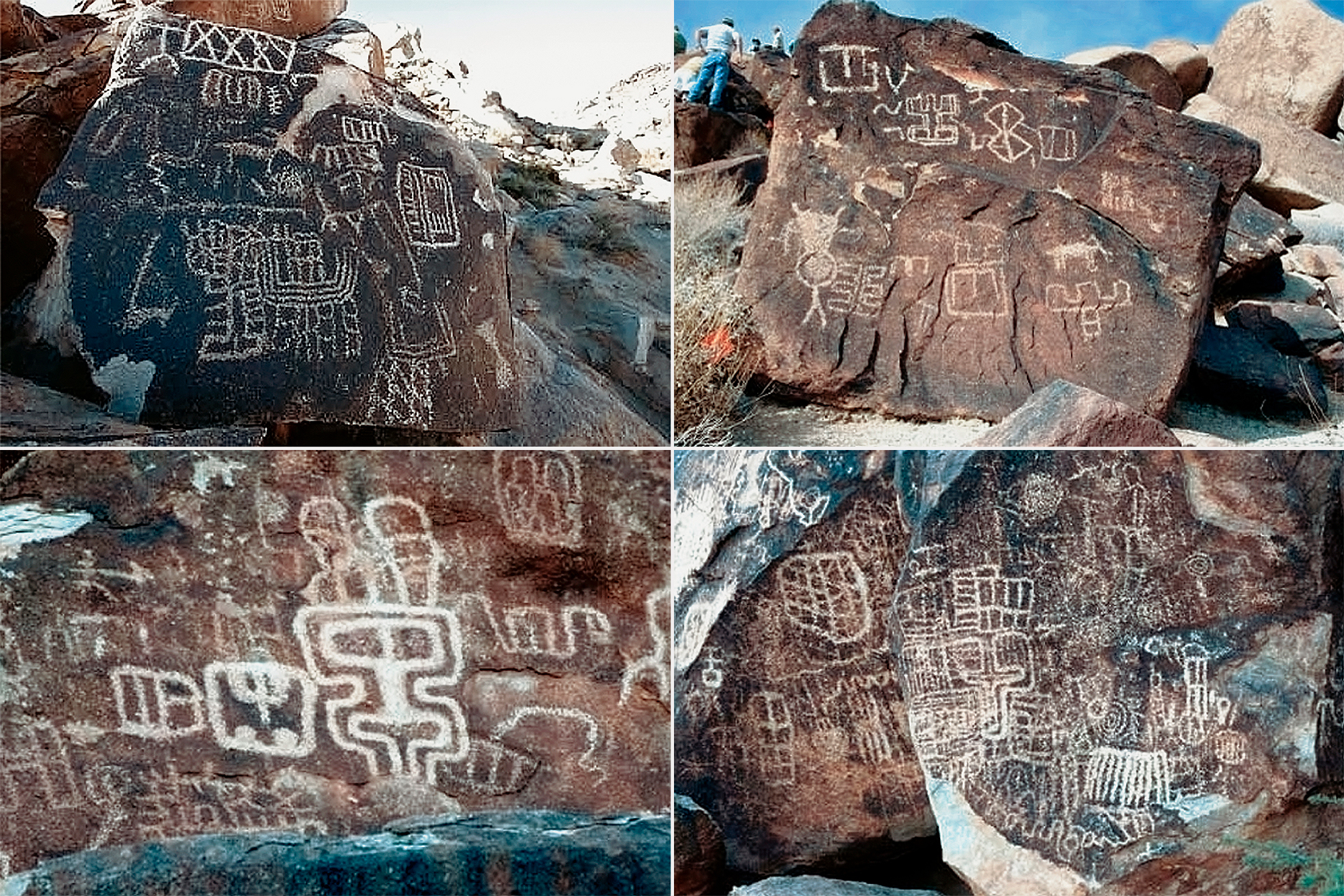
The site has a long history of use, dating from prehistoric times to contemporary expression; it is culturally significant to modern Indian Peoples living in the region. Many designs appear to have been carefully reworked or refreshed over a long period, attesting to the enduring cultural significance of this place and its art. These "refreshings" often exhibit great care to respect the outlines of the design being enhanced; the dense packing of designs on the same boulder and superimpositioning also were done in a way that suggests enhancement not obliteration. The emphasis on abstract designs and the fact that representational imagery is only a small component of the total motif assemblage can be argued to be indicative of a form of symbolism that was restricted in terms of those who had access to its meanings and authorized to provide exegeses of it (Quinlan & Woody 2009).
Nevada Rock Art Foundation volunteers contributed a prodigious 1400 field hours during the project, recording approximately 300 rock art panels as well as graffiti. The level of eff ort required is far greater than a regular 300 panel site. The complex superimpositioning and sheer size of so much of Grapevine Canyon's rock art made the production of scale line drawings very time consuming and difficult. The site's challenging topography and geology made many panels hazardous to access safely, also adding time to the recording process.
Acknowledgments
We thank Steve Daron (nps) for the opportunity of working on this project with the National Park Service. George Phillips did a great job in promoting participation by Clark County site stewards and provided welcome assistance in the field. The Lake Mead cultural resources team, led in the field by Erin Eichenberg, was a pleasure to work with. Jessica Bland (nps Public Interpretation) expertly handled the public’s curiosity about the documentation process. Felton Bricker (Fort Mojave) generously shared some of his cultural insights about the site with the project crew. We thank the field and office volunteers for their hard work in making this project such a success.
Field volunteers
C. Barnes-Wolfe, J. Bingham, C. & G. Breaz, T. Broderick, L. Burkholder, K. & M. Compton, J. Day, C. Elting, J. Hickman, A. Higgins, J. Hoke, E. Holmes, R. Hoving, R. Huntsman, B. James, J. Johnson, C. & M. Kallerud, R. Keough, E. Laine, C. Kawanishi, A. McConnell, D. & J. Mitchell, T. Price, P. Reynosa, J. Rhinehart, S. Roberts, D. Rorer, E. Ross, C. & J. Sanchez, R. Spurlock, W. Starker, R. Taylor, M. Washburn, and M. Westcamp. Lab (inking) volunteers—P. Bailey, S. Bailey, C. Barnes-Wolfe, L. Befort, J. Bingham, B. Bruce, L. Cano, A. Carter, J. Davenport, P. DePatta, M. Duvoisin, C. Elting, P. Eshelby, M. Hanson, E. Holmes, R. Huntsman, M. Jones, R. Keough, M. MacMurtrie, D. Massengale, D. May, A. McConnell, J. McCool, L. Nations, T. Price, B. Taylor, W. Robison, E. Ross, M. Sheets, W. Wallace, and D. & P. Wescott.
References
Christensen, D. D. and J. Dickey, 2001, The Grapevine Style of the Eastern Mojave Desert of California and Nevada. In American Indian Rock Art, volume 27, edited by S. Freers and A. Woody, pp. 185-200. American Rock Art Research Association, Tucson. Quinlan, A. R. and A. Woody, 2009, Rock Art in Archaeological Thought. In Nevada Rock Art, by Peter Goin, pp. 27-40. Black Rock Institute Press, Reno.
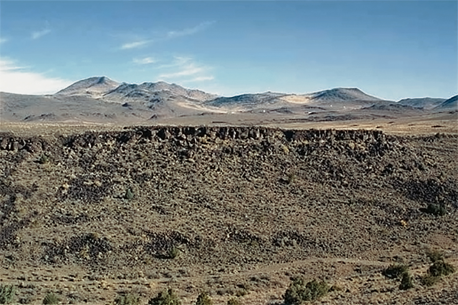
Lagomarsino is a large petroglyph site, a quarter of a mile in length, containing 2229 rock art panels located on an east-west trending, fine-grained basalt cliff and associated talus slope below. The site is located in the hinterland of the Comstock Mining District (Virginia City), and the modern urban centers of Reno, Sparks, and, Carson City are not far away. The site is a popular destination for outdoor enthusiasts of all varieties yet remains relatively intact with graffiti and other vandalism only noticeably increasing in the last 20 years, despite the high level of unsupervised public visitation.
Lagomarsino's Importance In North American Rock Art Studies
The Lagomarsino site has been well known for a very long time; Julian Steward (1929) recorded the site as "208 Pt Virginia City, Nevada" based on a 1904 report from a local Reno resident. The site was later recorded by researchers from the University of California, Berkeley in the 1950's (Baumhoff et al. 1958). This archaeological inventory estimated that Lagomarsino comprised 600 rock art panels, of which 439 were photographed, and analyzed; line drawings of 160 panels were made from these photographs (Heizer and Baumhoff 1962:294-303). The work of the University of California, Berkeley, was the only official archaeological recording of this important site until Nevada Rock Art Foundation's documentation project began in June 2003.
Lagomarsino's importance in the history of western Great Basin rock art studies derives, in part, from its role in the development of Heizer and Baumhoff's (1962) classification of the region''s rock art styles. More importantly, these researchers established the hunting magic approach as the dominant interpretation of rock art in the region until the 1980's. Their variant of hunting magic was inspired, in part, by their experience and analysis of Lagomarsino (Baumhoff et al. 1958; Heizer and Baumhoff 1962). They pointed to the site's favorable hunting environment and motif types (mountain sheep and possible portrayals of piñon cones) that they argued depicted "natural objects, the increase of which would be advantageous to the Indians' economy" (1962:290-291).
The Lagomarsino Canyon Petroglyph Site Documentation Project
This episode raised the issue of how Lagomarsino could be protected in the future. To enable programs of public interpretation and effective site monitoring, a complete archaeological inventory of Lagomarsino was necessary, and in 2003 the Nevada Rock Art Foundation in partnership with Storey County, the Nevada State Museum, nrcs, and other agencies, commenced a program of detailed archaeological documentation at the site.
Field Work And Documentation Methods At Lagomarsino
The fieldwork phase of the documentation project began on June 6th, 2003 and finished five years later, after a total of 10 fieldwork sessions, 143 workdays, and 10,908 volunteer hours on October 30th, 2008. The project produced a staggering quantity of data and materials: approximately 2,800 field drawings, 2,800 digitized panel drawings, and 10,3000 photographs (digital, black-and-white, and color slides), in addition to the imacs rock art attachment records and field logs.
All rock art panels, graffiti, and vandalism were recorded in the field using Nevada Rock Art Foundation's standard noninvasive methods. All panels were assigned a unique alphanumeric identifier tied to the spatial control grid that was established. Originally it was planned to relate identifi ed rock art panels to natural groupings defined by topography and setting. However, the experience of the first fieldwork session in June 2003 demonstrated that this would not be practical for a project envisaged to last several years if total survey coverage was to be achieved.
Although there are areas of the site where rock art is distributed in dense natural groups, the general pattern is of rock art spread throughout the talus slope at the base of the cliff in varying densities, over an area of some 325 acres in Sections 5-11; Section 12 covers an area of approximately 220 acres but has just two rock art panels.
Accordingly, after rock art was recorded in Section 8A in June 2003, a baseline grid was imposed on the site. This grid was ideally conceived as composed of rectangular blocks (or sections) of equal size (10x25m), oriented north-south (numeric designator) and east-west (alpha designator). This ideal grid could not be realized in practice due to variations in site topography (aspect, elevation, etc.). Therefore, the individual sections vary somewhat in size, but most cover an area of approximately 200 m2 and off er a useful guide to spatial variation in the density of panel distribution across the site. As the purpose of the grid was for survey planning and ensuring total documentation coverage, the variability in section dimensions is not significant. The corners of the grid sections were marked in the field by placing rebar at their intersection so that the sections could be relocated and re-established each year.
The cliff face and Locus A are the only areas of the site that were defined by distinctive, natural topographic features rather than the arbitrary grid. The cliff face and its immediate vicinity to the intersection of the highest arbitrary grid section were recorded as Rim Rock sections 6-12. The vast majority of rock art panels in the Rim Rock sections is located on the cliff face, some on boulders in front of the cliff face, and a few are located on the plateau above the cliff face. They form natural groupings, though the divisions between the Rim Rock sections are arbitrary. Locus A is a small grouping of rock art panels located next to a dirt road that leads into the site.
Site Description
Previous estimates of the quantity of rock art at Lagomarsino ranged from 600-1,000 panels of prehistoric art (Baumhoff et al. 1958; Quinlan and Woody 2001). During the Nevada Rock Art Foundation's 5-year recording project at the site, an area of 86,000 m2 was surveyed and 2,219 prehistoric rock art panels identified, as well as a signifi cant quantity of graffiti and other vandalism. In general rock art is distributed throughout the talus and cliff face, with some prominent high density areas of rock art discernible. Sections 7(19.6%), 8(39%), and 9(23.6%) contain over 80% of the site's rock art. The highest concentrations of rock art are discernible on the cliff-face (Sections 7RR, 8RR, and 9RR) and at the base of the talus slope (Sections 8A, 8A2, 8B2, 8C2, 9B2, 9C1, 9D2, 7D1, 7D2, 7E1). Mid-slope areas of the site also have significant numbers of rock art panels, but across the site there is a general trend that areas high on the talus slope leading to the intersection of the cliff face area (6RR-12RR) have low numbers of panels.
Rock art in the rim rock sections is particularly notable for its prominent landscape position, with commanding views of the canyon and site, size, and quality of execution. The designs in these sections are highly visible from the canyon bottom and appear to have been made in such a way as to enhance their visibility. Their designs are deeply pecked with wide lines and are large in size and the largest panels (in terms of surface area covered) are located in sections high on the talus slope or on the cliff face. E.g., panels in 8RR on average cover a surface area of 1.03 m, in 9RR, 0.86m; in 7RR, 0.8 m; but in 8A and 8A2 at the bottom of the talus, panels on average cover a surface area 0.24-0.27m. Rock art in Sections 8A and 8A2 is prominent by virtue of its abundance and proximity to the base of the talus slope, readily apparent to a casual passerby and near the occupation area of the site (see the Other Archaeological Features section on the next page for more information about the occupation area).
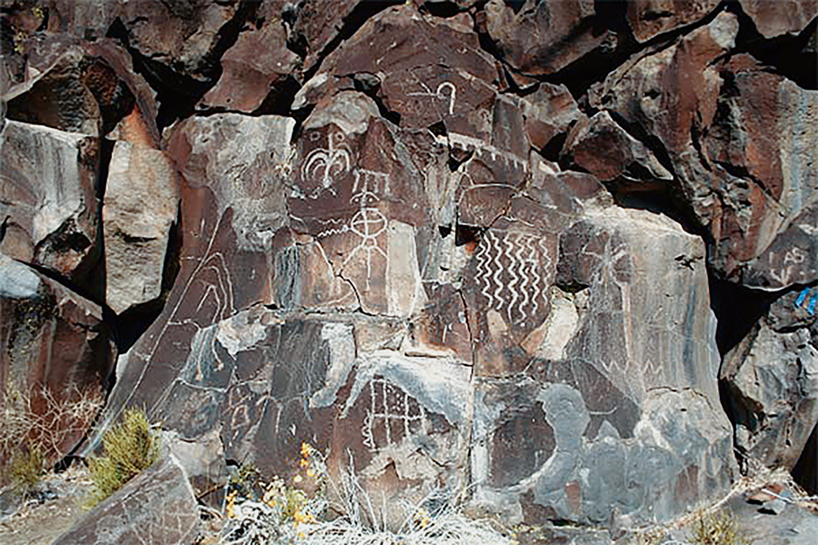
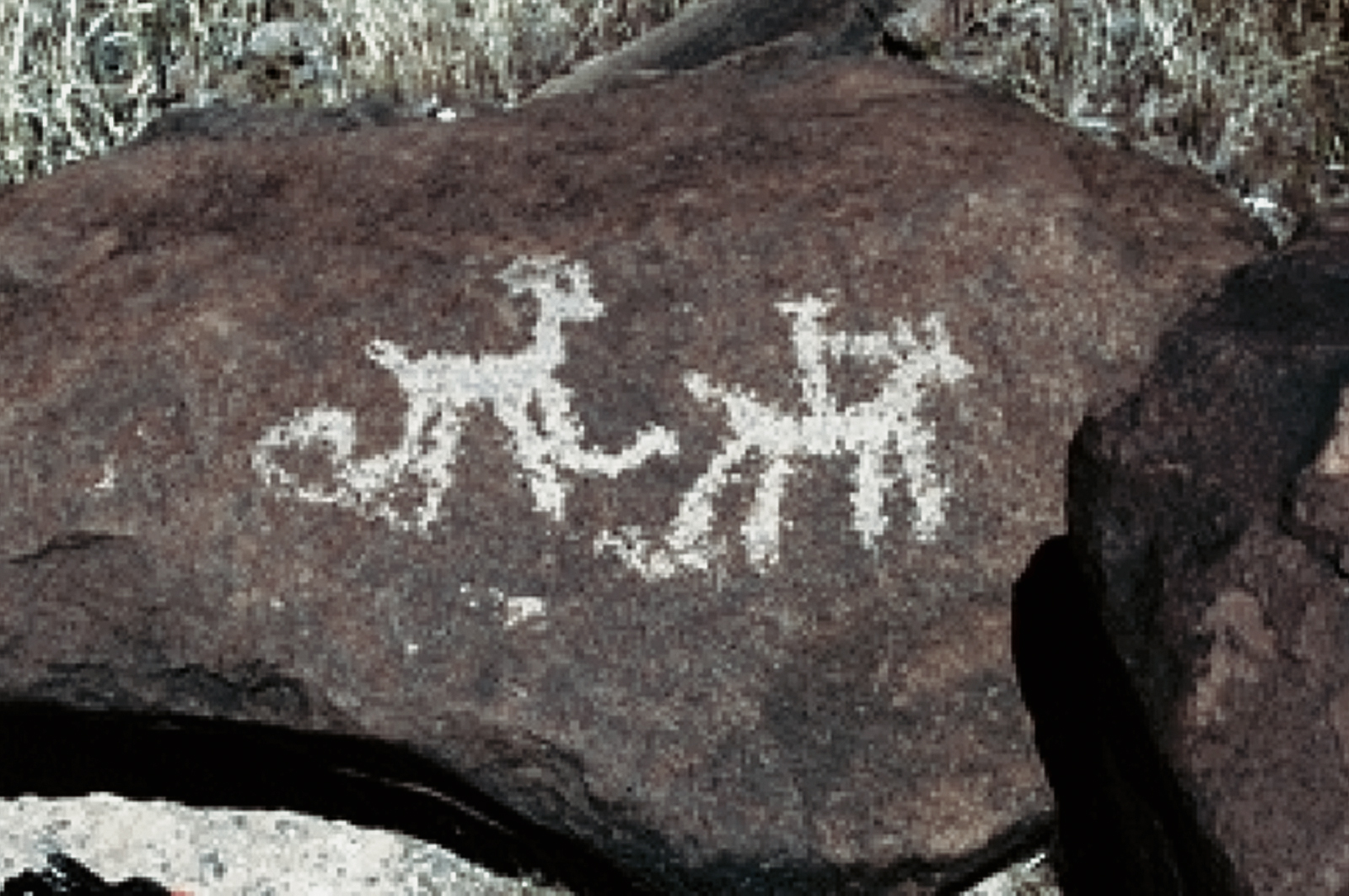
All the rock art at Lagomarsino is petroglyphic in method of production, with over half (1,334 panels) containing design elements made by solid pecking as the primary technique, with stipple pecking (703 panels) the second most common technique. Other petroglyph techniques observed include abrasion and scratching. The motifs (n=4,600) present run the full range of Basin and Range Tradition types and are dominated by abstract designs. Representational or naturalistic designs account for only 2.6% of the total motifs present at the site. Zoomorphs (19) are strikingly rare and bighorn sheep motifs, which are often regarded as one of the characteristic motif types of Great Basin rock art, are very rare (just five and only two of these are classic specimens of the stylistic treatment of this animal in Great Basin rock art). No other large or medium-sized mammals are represented in the site's art; the only other animal type portrayed in any frequency is lizards (7). Portrayals of the human form are largely variants of Basin and Range Tradition stick figures, though naturalistic representations of feet (29) are a significant component of the site's corpus of anthropomorphs.
Possible schematic portrayals of objects of everyday life are present at the site. Most signifi cant are geometric and linear designs identified by Washoe elders as traditional basket designs or textiles (55) that include hunting nets. One panel contains naturalistic treatments of Elko series projectile points. There are also schematic designs conventionally regarded by rock art researchers as referring to atlatls.
Abstract imagery includes motifs that are characteristic of Basin and Range Tradition art: circles, dot rows, arcs, rakes, wavy lines, perpendicular linear designs, grids, and a range of geometric forms. Rectilinear and curvilinear forms (2,129) outnumber circular designs (1,206). Many linear forms, particularly simple vertical and horizontal lines that occur singly, appear to be more expedient or performative in the way that they were made; i.e., the act of marking a mark was probably the primary motivation in their production. The site's very well-made, deeply pecked, large, imposing abstract designs, concentrated on the cliff face and high up the talus slope, comprise rakes, schematic representations of textiles, fields of dots, circles with long trailing lines, one anthropomorph with outstretched arms, etc., and were probably made by master artists. The quality of much of the art, its design types, and style of execution make Lagomarsino a particularly good example of Basin and Range Tradition. The site's dominant emphasis on abstract imagery is somewhat unusual for Great Basin rock art sites, and the size of many of the site's designs are among the largest in Nevada.
Some spatial patterning in the relative balance between representational, linear, and circular motif types is discernible. Linear forms predominate in nearly all sections, as would be expected given their abundance at the site. Representational forms are rare but appear to avoid locations high up the talus slope and are never numerically the most prominent design type in a section (with the exception of Section 6E2). Circular forms occur in conspicuously low percentages in Sections 7RR, 8RR, and 9RR on the cliff face, and tend only to be a signifi cant component of motif assemblages in sections that have less than 40 panels. More detailed analysis of the spatial relationships among the different motif types may be able to identify whether there is any chronological patterning underlying these basic spatial patterns.
Although currently there is no scientific way of dating petroglyphs, a few designs described above give clues to the age of some the site's art. There are a small number of circles bisected by a vertical line that may be schematic treatments of atlatls, as well as a panel with naturalistic portrayals of Elko series points, indicating a Middle Archaic date for some of the rock art at the site. The naturalistic textile designs identified by Washoe elders as traditional basket designs (Quinlan and Woody 2001), indicate that some of the site's rock art may have been made into the late Prehistoric and ethnohistoric times. The sheer quantity of Lagomarsino's rock art indicates that it was probably made over a long period of repeated use. The presence of representations of objects used in everyday life other than just atlatls or bow-and-arrows is distinctive-few rock art sites are known elsewhere in Nevada that contain representations of equipment used for resource processing and storage.
Although the site contains a significant quantity of graffiti and other vandalism, the frequency of vandalism is proportionate to a rock art site of this scale and is generally not visually intrusive to the site's setting. Some vandalism does directly impact prehistoric art, but the most serious case of vandalism (to Panel 7RR-13, described above) was mitigated by Nevada Rock Art Foundation in 2003 (Dean 2003). Most graffiti and other vandalism is only visible when up close to it, and much of this takes the form of lightly scratched initials and other marks, though some attempts at imitating prehistoric design elements are present. Vandalism is generally found in areas of the site that have the most prominent designs (the cliff face and at the base of the talus slope) and natural routes across the site. This suggests that much vandalism can be related to casual site visitation and is directed at those areas of the site that attract the most attention. Natural destructive agents include surface spalling, lichen growth, and exposure to the elements. In addition, some boulders bearing rock art have tumbled down the talus slope from their original position. Despite these impacts the site is in good condition.
Other Archaeological Features
Baumhoff et al. (1958) reported a small occupation site associated with Lagomarsino's rock art and a game drive wall. The putative game drive wall is more likely a historic feature based on its extent and substantial character; qualities that do not match historically or archaeologically observed hunting features. Other archaeology reported from the site includes a Stemmed Point that was collected in the late 1980s. The archaeological features that Nevada Rock Art Foundation observed during its recordation of the site's rock art are concentrated in Section 8A and include milling features and two projectile point fragments. It is likely that the site was seasonally occupied for a variety of economic purposes, including seed and plant processing, suggesting the site's rock art was viewed and used by a broader cross-section of the social group than just hunters or ritual specialists. This indicates the site's rock art may have been incorporated in social and ceremonial practices of community-wide significance.
Evaluating Rock Art At Lagomarsino
The archaeological value of places such as Lagomarsino is rooted in rock art being among the oldest and most enduring forms of the ideological presentation of identity and cultural practice, providing information on diachronic variation in past social processes, symbolic behavior, landscape use, and the role of graphic systems of signification in cultural systems (Quinlan and Woody 2009). Its cultural significance potentially extends beyond its original makers, as rock art sites are monuments that were re-used and incorporated in the traditions of subsequent cultures, illustrating the importance of place in the social construction of individual and cultural identities (Bradley 2000; Quinlan and Woody 2003, 2009). Sites able to provide data that address these research themes in archaeology and anthropology are of exceptional signifi cance for understanding developments in human social behavior, particularly the role of monuments in shaping the experience of social and economic routines, and the development of symbolic culture.
Further, the implicit long duration of site-use presented by Lagomarsino's quantity of rock art and the age of its associated archaeology attests to its power as a special place that repeatedly drew prehistoric peoples to it and its continuing cultural significance to Native American peoples.
Conclusion
The Lagomarsino Canyon Petroglyph Site Documentation Project has resulted in one of the most exhaustive records of a large rock art site produced in Nevada. Over 2200 rock art panels were documented through field drawings, photography, geospatial data capture, and field observations, as well as all observed graffiti and other vandalism. These data provide the basis for future culture resource management at the site and programs of public interpretation. The project's findings justify Lagomarsino's reputation as one of the most significant archaeological sites of its type in the Great Basin. Its scale and quality are impressive, and the site conveys a strong sense of place and prehistoric social routines. Lagomarsino derives a broader significance from its role in the development of the archaeological study of Great Basin rock art sites, having shaped explanatory approaches to rock art's prehistoric sociocultural contexts of use and in stylistic analyses of prehistoric art. The site retains considerable research potential and will continue to shape the way archaeologists conceptualize the role of visual symbolism in prehistoric societies.
Acknowledgements
This project was planned and developed by Dr. Alanah Woody, who led fi eldwork and data management until her death in July 2007. Without her vision and commitment to the long-term protection of Lagomarsino and all Nevada rock art, this project would not have been possible. This project was funded in part by grants provided by the National Endowment for the Arts and us Forest Service; the National Park Service administered through the Nevada shpo; and Patagonia. Other financial support was provided by the generous donations of panel program sponsors: Sharon P. Chase, Catherine S. Fowler, Don D. Fowler, Douglas Fowler, Don Frazier, John Gianotti, Charles Greene, Thomas and Peggy Hall, Sam and Kathleen Hayes, Bill Jackson and Joanne Jackson, Dittany Lang, Petit Gilwee, Elizabeth Sweeney, Keegan Turner, Tavis Turner, and David and Patricia Vaughn. Additional support was provided by Dan Smercina and Western Village Inn-Casino. Our photography needs are serviced through the generous support of Ed Laine Photography and Jim and Laura Ouimet. We thank our partners for their support and technical assistance: Storey County, the Nevada State Museum, usda, Natural Resources Conservation Service, and the Nevada Department of Transportation (Geodesy and Location Divisions). Cheryln Bennett, Ralph Bennett, Joan Johnson, and Dianne Jennings provided invaluable support with the management of this project. Lastly, we thank all the volunteers who contributed to this project-their efforts are greatly appreciated.
References Cited
Baumhoff , Martin A., Robert F. Heizer and Albert B. Elsasser
1958 The Lagomarsino Petroglyph Group (Site 26-St-1) near Virginia City, Nevada. Reports of the University of California Archaeological Survey, No. 43, Berkeley.
Bradley, Richard
2000 An Archaeology of Natural Places. Routledge, London.
Dean, Claire J.
2003 Site 26-ST-1, Storey County, Nevada: Conservation Treatment Record, October 2003. Portland Dean & Associates Conservation Services, Oregon. Report submitted to the Nevada Rock Art Foundation, Reno.
Heizer, Robert F. and Martin A. Baumhoff
1962 Prehistoric Rock Art of Nevada and Eastern California. University of California Press, Berkeley.
Quinlan, Angus R. and Alanah Woody
2001 Marking Time At Lagomarsino: The Competing Perspectives Of Rock Art Studies. In American Indian Rock Art, Volume 27, edited by Steven M. Freers and Alanah Woody, pp. 211-220. American Rock Art Research Association, Tucson, Arizona.
2003 Marks of Distinction: Rock Art and Ethnic Identification in the Great Basin. American Antiquity 68(2):372-390.
2009 Rock Art in Archaeological Th ought. In Nevada Rock Art by Peter Goin, in press. Black Rock Institute Press, Reno.
Steward, Julian H.
1929 Petroglyphs of California and Adjoining States. Publications in American Archaeology and Ethnology, Vol. 24, No. 2, pp. 47-238. University of California, Berkeley.
The Sloan Canyon Petroglyph Site is a National Register-listed property in the Sloan canyon National Conservation Area, Clark County. In 2006 the BLM had Nevada Rock Art Foundation document the site to gather data that would allow a condition assessment to be made. Nevada Rock Art Foundation's report was completed in the winter of 2007 and an overview of the project is provided here.
Background
The Sloan Canyon site is located in the northwestern McCullough Range, south of Las Vegas and Henderson. The site had previously been recorded by the Harry Reid Center for Environmental Sciences (HRC) in 1997/98 and by Far Western Anthropological Group in 2004. HRC's work focused on providing an inventory of the site's rock art and defined its spatial characteristics and established its boundaries. Their work was supplemented by Far Western’s investigations that identified other archaeological features at the site and noted additional rock art panels, extending the northern boundary of the site.
HRC identified some 318 rock art panels at the site, distributed throughout Sloan Canyon over approximately a mile. HRC divided the site into four sections (Lower Canyon, Middle Canyon, Upper Canyon, and Narrows). Each section was composed of varying numbers of loci. The greatest concentration of rock art panels was noted in the Middle Canyon and Narrows areas of the site, which are located midway through the canyon. Far Western supplemented this record with the identification of 14 additional rock art panels and 7 archaeological features. The results of these archaeological surveys indicate that the Sloan Canyon area has evidence of Middle Archaic, Late Archaic, Puebloan, and Late Prehistoric occupation, mainly connected with resource procurement and processing.
Recording Sloan Canyon
The objectives of the Nevada Rock Art Foundation site recording conducted in spring 2006 were to produce accurate scale drawings, archival photo documentation, a GPS datalog, and IMACS records of all rock art panels at the Sloan Canyon site. In addition, public education in the form of training in rock art site documentation methods was provided to site stewards for the site. Where possible, all previously identified rock art panels were relocated in the field and assigned the designation given them by HRC. Panels that had not been previously identified were given a numeric designation. After relocating previously recorded panels, each locus underwent pedestrian survey to identify additional rock art panels and archaeological features. Each identified panel was then documented by: a scale line drawing; photography in digital and print formats; the preparation of an IMACS rock art attachment form; and its location mapped using a hand-held GPS device.
Style
Sloan Canyon's rock art is predominantly Basin and Range Tradition in character. Abstract motifs account for about 89 percent of the 1133 motifs present. Circular forms are more frequent motif types than rectilinear designs or variants of lines. In terms of numbers of panels, though, these three broad forms occur in roughly equal quantities, but variants of lines are slightly less common. In general, there is little spatial variation across the site in the distribution of abstract motif types; i.e., discrete spatial patterning in the occurrence of the three broad abstract types is not discernible.
Some specific abstract motif types are, however, localized in their distribution. So-called "necklace" designs (two nested arcs outlined by a row of dots that follows the contour of the outer arc) are found only in Upper Canyon I. Possible "atlatl" representations are rare, but seem to be concentrated in Middle Canyon I. If these really are schematic "atlatls," then this might indicate a Middle Archaic date for some rock art production at that location.
Overall, the abstract imagery at the site exhibits a tendency to open forms, sometimes with other motifs inside. Its opaque references probably encouraged ambiguity in the cultural interpretations attached to it by its users, perhaps indicating that it functioned to provide an exegetic space for the expression of competing social narratives, a common function of visual symbolism. Alternatively, it may have had very specific cultural meanings for its users, meanings that an external observer cannot "read" based simply on a visual consideration of its properties.
Some art may be more performative in its motivation than other types. Simple vertical lines, usually occurring singly, account for about 10 percent of all motifs at the site. As these are not related to other design elements they may be related to practices where leaving a mark was the main motivation.
Figurative forms tend to evoke greater interest from modern observers of rock art, largely because their apparently representational nature gives us a false confidence that we can identify its subject and cultural references. These motif types also bear the burden of style definitions in rock art studies as stylistic variation is easier to recognize in forms for which the apparent theme or subject can be identified.
Representational forms are statistically a small component of the Sloan Canyon rock art assemblage, only about 11 percent of all motifs but approximately 23 percent of all panels. Anthropomorphs outnumber zoomorphs in the number of panels in which these are present, but zoomorph motifs are slightly more frequent than anthropomorphs. In general, anthropomorphs tend to be represented singly in contrast to zoomorphs, a greater proportion of which are depicted with other zoomorphs.
Most zoomorphs and anthropomorphs at the site are of types that are not culturally specific. Two anthropomorphs are historic in character as they appear to be wearing cowboy hats and one is apparently holding a rifle. One other anthropomorph may be historic in age as it is depicted apparently riding a quadruped. These historic motifs may be important records of early contact between Native Americans and Euro-Americans. The remaining anthropomorphs at the site predominantly are Basin and Range Tradition stick-figure anthropomorph types.
Explaining Sloan Canyon's rock art
Although the archaeology of Sloan Canyon NCA documents the presence of Puebloan, Patayan, and Southern Paiute peoples (among others), these cultural identities seem to be only weakly expressed through the site's rock art. If the rock art did function to construct and communicate cultural identities with external groups, it did this in a way that we cannot apprehend through its motif assemblage.
Some rock art is directly associated with milling features and the general archaeological context of the site's art is one of resource acquisition and procurement, and temporary habitation for task-specific purposes. The informing context in which prehistoric populations would have used and encountered the site's rock art is one of daily economic and social routines.
The art is generally not in spaces that can be considered private (other than the few panels that are up high above the canyon floor and that are difficult to access) and largely is placed in natural traffic corridors or activity areas. Therefore, it is likely that Sloan Canyon's rock art negotiated and expressed social identities experienced in the routines of daily social life. The art may have been used in a cultural discourse that allowed people to reflect on the lived experience of social and domestic routines, providing a physical embodiment of a social memory that transcended individual experience.
Acknowledgments
We are grateful to the BLM Las Vegas Field Office for the opportunity to have participated in this project and thank Mark Boatwright, Charlie Carroll, and Lola Henio for the various support and assistance they provided during the project. Fieldwork was led by Angus Quinlan assisted by Barbara Struble and Alanah Woody.
As ever, Nevada Rock Art Foundation volunteers were invaluable in the field and included: Linda Avance, Susan Bailey, Barbara Bane, Frank Bisceglia, Martha Burk, Richard Capp, Dan Clark, Kathy Clark, Kathie Clinesmith, Larry Clinesmith, Pam Cramer, Frank Crosser, Sue Crosser, Brian Curwen, Vicki Curwen, Peter Davis, Cheryl Ference, Bob Fowler, Grace Maderas, Nancy Gentis, Barron Haley, Anne Higgins, Elaine Holmes, Bill James, Darwin Johnson, Dale Kavula, Rose Keogh, Norman Kresge, Marilyn MacMurtrie, Brendan Mangan, Jona Mangan, AnneMcConnell, Deb Mitchell, John Mitchell, Franco Moller, Patricia Moller, Inge Nagel, Linda Nations, Denis O’Brien, Joan O’Brien, Alan Personious, Lynne Personious, Paula Reynosa, Rebecca Scharf, Matthew Schneider, Mary Sheets, Barbara Slivac, Jill Stovall, Jeff Thelen, Lorrie Vavak, Gary Vetter, Loretta Watson, Margaret Westcamp, and Chuck Williams. Volunteers who helped to process field drawings included: Carolyn Barnes-Wolfe, Anne Carter, Janice Hoke, Elaine Holmes, Bill Jackson, Joanne Jackson, Pan Lambert, Anne McConnell, and Laura Ouimet.
→ Subscribe free to the Bradshaw Foundation YouTube Channel
→ America Rock Art Index
→ The Rock Art of Baja California
→ Baja On Film
→ California Rock Art Foundation
→ Baja In Search of Painted Caves
→ Baja Great Murals Gallery
→ Sierra de San Francisco
→ Baja 2018 Expedition
→ The Rock Art of the Lower Pecos Canyonlands
→ Color Engenders Life
→ The Rock Art of Arizona
→ The Rock Art of Nevada
→ Coso Sheep Cult of East California
→ Coso Range Rock Art Gallery
→ The Rock Art of Moab Utah
→ The Rock Art of the Oregon Territory
→ RAN - USA Colloquium 2018
→ Removal & Camouflage of Graffiti
→ Graffiti Dates & Names
→ Vandalised Petroglyphs in Texas
→ Preserving Our Ancient Art Galleries
→ Bradshaw Foundation
→ Rock Art Network